Login
Register


BMQ
Burnet Municipal/Kate Craddock Field Airport
Official FAA Data Effective 2025-11-27 0901Z
Chart Supplement

VFR Chart of KBMQ
Sectional Charts at SkyVector.com
IFR Chart of KBMQ
Enroute Charts at SkyVector.com
Location Information for KBMQ
Coordinates: N30°44.34' / W98°14.32'Located 01 miles SW of Burnet, Texas on 143 acres of land. View all Airports in Texas.
Surveyed Elevation is 1283 feet MSL.
Operations Data
|
|
Airport Communications
| ASOS: | 119.925 Tel. 512-756-7277 |
|---|---|
| CTAF: | 122.800 |
| UNICOM: | 122.800 |
| AWOS-3 at DZB (14.5 SW): | 119.775 830-598-2059 |
| AWOS-3PT at RYW (20.0 SE): | 119.375 512-267-1365 |
| AWOS-3 at AQO (22.0 W): | 119.425 325-247-2189 |
- APCH/DEP CTL SVC PRVDD BY HOUSTON ARTCC (ZHU) ON FREQS 132.35/317.5 (LOMETA RCAG).
Nearby Navigation Aids
|
| ||||||||||||||||||||||||||||||||||||||||||||||||||||||||||||


Runway 01/19
| Dimensions: | 5001 x 75 feet / 1524 x 23 meters | |
|---|---|---|
| Surface: | Asphalt in Good Condition | |
| Weight Limits: | S-30 | |
| Edge Lighting: | Medium Intensity | |
| Runway 01 | Runway 19 | |
| Coordinates: | N30°43.94' / W98°14.45' | N30°44.73' / W98°14.18' |
| Elevation: | 1258.4 | 1283.2 |
| Traffic Pattern: | Right | |
| Runway Heading: | 16° True | 196° True |
| Markings: | Non-Precision Instrument in good condition. | Non-Precision Instrument in good condition. |
| Glide Slope Indicator | P4L (3.00° Glide Path Angle) | P4L (3.03° Glide Path Angle) |
| REIL: | Yes | Yes |
| Obstacles: | 32 ft Power Line 1300 ft from runway | 28 ft Trees 820 ft from runway, 290 ft right of center |
Services Available
| Fuel: | 100LL (blue), Jet-A |
|---|---|
| Transient Storage: | Tiedowns |
| Airframe Repair: | MAJOR |
| Engine Repair: | MAJOR |
| Bottled Oxygen: | NONE |
| Bulk Oxygen: | NONE |
| Other Services: | AIR AMBULANCE SERVICES,AVIONICS,PILOT INSTRUCTION,AIRCRAFT RENTAL |
Ownership Information
| Ownership: | Publicly owned | |
|---|---|---|
| Owner: | CITY OF BURNET | |
| PO BOX 1369 | ||
| BURNET, TX 78611 | ||
| 512-756-6093 | ||
| Manager: | ADRIANNE FEILD | ADMIN SERVICES/AMGR 512-715-3214. |
| PO BOX 1369 | ||
| BURNET, TX 78611 | ||
| 512-756-6655 | FBO. | |
Other Remarks
- DEER INVOF AIRPORT.
- RWY 19 PREFERRED CALM WIND RWY.
- FOR CD CTC HOUSTON ARTCC AT 281-230-5622.
- DUSK-DAWN. REIL RWY 01 & 19; PAPI RWY 01 & 19; MIRL RWY 01/19 PRESET LOW INTST; TO INCR INTST & ACTVT - CTAF.
Weather Minimums

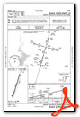
Instrument Approach Procedure (IAP) Charts

Nearby Airports with Instrument Procedures
| ID | Name | Heading / Distance | ||
|---|---|---|---|---|
 |
KRYW | Lago Vista Tx/Rusty Allen Airport | 135° | 20.0 |
|
KAQO | Llano Municipal Airport | 277° | 21.9 |
|
KLZZ | Lampasas Airport | 005° | 22.1 |
|
3R9 | Lakeway Airpark Airport | 150° | 26.1 |
|
KGRK | Robert Gray AAF Airport | 046° | 28.9 |
|
KGTU | Georgetown Exec Airport | 096° | 29.1 |
|
KILE | Skylark Field Airport | 053° | 35.3 |
|
81R | San Saba County Municipal Airport | 320° | 38.7 |
|
KEDC | Austin Exec Airport | 120° | 40.4 |
|
T74 | Taylor Municipal Airport | 103° | 42.4 |
|
KAUS | Austin-Bergstrom International Airport | 137° | 44.0 |
|
T82 | Gillespie County Airport | 229° | 45.7 |
Airport Images
Do you have a recent image of this airport? Upload it here!


