Login
Register


T74
Taylor Municipal Airport
Official FAA Data Effective 2026-01-22 0901Z
Chart Supplement

VFR Chart of T74
Sectional Charts at SkyVector.com
IFR Chart of T74
Enroute Charts at SkyVector.com
Location Information for T74
Coordinates: N30°34.36' / W97°26.59'Located 02 miles W of Taylor, Texas on 106 acres of land. View all Airports in Texas.
Surveyed Elevation is 600 feet MSL.
Operations Data
|
|
Airport Communications
| AWOS-3PT: | 119.75 Tel. 512-352-4995 |
|---|---|
| AUSTIN APPROACH: | 127.225 317.65 |
| AUSTIN DEPARTURE: | 127.225 317.65 |
| UNICOM: | 122.800 |
| CTAF: | 122.800 |
| SZAGI STAR: | 118.15 ;SFC-7000 FT 119.0 ;8,000-12,000 FT 350.25 ;SFC-7000 FT 370.85 ;8,000-12,000 FT |
| ILEXY DP: | 127.225 317.65 |
| SAYBR DP: | 127.225 317.65 |
| MUCKY DP: | 127.225 317.65 |
| ELOEL DP: | 127.225 317.65 |
| AEROZ DP: | 127.225 317.65 |
| BNDIA DP: | 127.225 317.65 |
| GABOO STAR: | 127.225 317.65 |
| POTRR STAR: | 127.225 317.65 |
| AWOS-3 at EDC (12.4 SW): | 118.825 512-616-2967 |
| AWOS-3PT at GTU (13.7 NW): | 512-869-3430 |
| ATIS at GTU (13.8 NW): | 118.6 |
Nearby Navigation Aids
|
| ||||||||||||||||||||||||||||||||||||||||||||||||||||||||||||


Runway 17/35
| Dimensions: | 4000 x 75 feet / 1219 x 23 meters | |
|---|---|---|
| Surface: | Asphalt in Fair Condition | |
| Weight Limits: | S-12 | |
| Edge Lighting: | Medium Intensity | |
| Runway 17 | Runway 35 | |
| Coordinates: | N30°34.69' / W97°26.60' | N30°34.03' / W97°26.58' |
| Elevation: | 600.0 | 547.9 |
| Traffic Pattern: | Right | Left |
| Runway Heading: | 179° True | 359° True |
| Displaced Threshold: | 249 Feet | |
| Markings: | Non-Precision Instrument in fair condition. | Non-Precision Instrument in fair condition. |
| Glide Slope Indicator | P2L (3.00° Glide Path Angle) | P2L (3.00° Glide Path Angle) |
| Obstacles: | 30 ft Trees 1030 ft from runway, 160 ft left of center | 55 ft Trees 835 ft from runway, 215 ft right of center APCH RATIO 25:1 TO DSPLCD THR OVR 80 FT TREES 2000 FT DSTC. |
Services Available
| Fuel: | 100LL (blue), Jet A+ |
|---|---|
| Transient Storage: | Tiedowns |
| Airframe Repair: | MAJOR HELI SVCS ALSO AVBL. |
| Engine Repair: | MAJOR |
| Bottled Oxygen: | NONE |
| Bulk Oxygen: | NONE |
| Other Services: | AIR AMBULANCE SERVICES,PILOT INSTRUCTION |
Ownership Information
| Ownership: | Publicly owned | |
|---|---|---|
| Owner: | CITY OF TAYLOR | |
| 400 PORTER STREET | ||
| TAYLOR, TX 76574 | ||
| 512-352-3675 | ||
| Manager: | STACEY BATCH | |
| 303 AIRPORT RD., #101 | ||
| TAYLOR, TX 76574 | ||
| 512-352-5747 | ||
Other Remarks
- THIS AIRPORT HAS BEEN SURVEYED BY THE NATIONAL GEODETIC SURVEY.
- FOR CD CTC AUSTIN APCH AT 512-369-7865.
- 200 FT. AGL TWR, 1000 FT EAST OF RWY CENTERLINE, APX MID POINT OF RWY.
- INTSV HEL ACTVTY ON AND INVOF ARPT.
- 100 LL & JET A SELF SERVE ONLY.
- MIRLS RWY 17/35 PRESET LOW SS-SR. TO ACTVT & INCR INTST - CTAF.
Weather Minimums

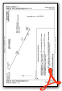
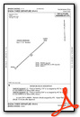
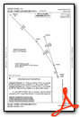
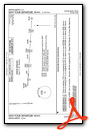
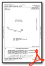
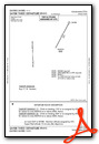
Standard Terminal Arrival (STAR) Charts
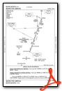
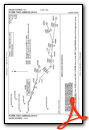

Instrument Approach Procedure (IAP) Charts
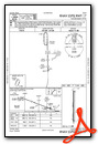
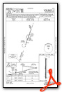
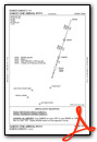
Departure Procedure (DP) Charts
Nearby Airports with Instrument Procedures
| ID | Name | Heading / Distance | ||
|---|---|---|---|---|
 |
KEDC | Austin Exec Airport | 211° | 12.3 |
|
KGTU | Georgetown Exec Airport | 297° | 13.8 |
|
KAUS | Austin-Bergstrom International Airport | 207° | 25.5 |
|
KRYW | Lago Vista Tx/Rusty Allen Airport | 260° | 27.6 |
|
3R9 | Lakeway Airpark Airport | 245° | 31.4 |
|
KILE | Skylark Field Airport | 337° | 33.2 |
|
KGYB | Giddings-Lee County Airport | 135° | 34.1 |
|
KTPL | Draughon-Miller Central Texas Regional Airport | 003° | 34.7 |
|
84R | Smithville Crawford Municipal Airport | 156° | 35.6 |
|
KGRK | Robert Gray AAF Airport | 326° | 35.7 |
|
KRWV | Caldwell Municipal Airport | 094° | 38.4 |
|
KBMQ | Burnet Municipal/Kate Craddock Field Airport | 283° | 42.4 |
Airport Images
Do you have a recent image of this airport? Upload it here!


