Login
Register


O32
Reedley Municipal Airport
Official FAA Data Effective 2026-02-19 0901Z
Chart Supplement

VFR Chart of O32
Sectional Charts at SkyVector.com
IFR Chart of O32
Enroute Charts at SkyVector.com
Location Information for O32
Coordinates: N36°40.26' / W119°27.06'Located 04 miles N of Reedley, California on 138 acres of land. View all Airports in California.
Surveyed Elevation is 386 feet MSL.
Operations Data
|
|
Airport Communications
| AWOS-3PT: | 120.175 Tel. 559-637-9453 |
|---|---|
| FRESNO APPROACH: | 132.35 323.25 |
| FRESNO DEPARTURE: | 132.35 323.25 |
| UNICOM: | 122.700 |
| CTAF: | 122.700 |
| ATIS at FAT (14.4 NW): | 121.35 |
| ASOS at FAT (14.5 NW): | 559-203-3918 |
| AWOS-3 at FCH (18.2 W): | 135.225 559-488-1040 |
Nearby Navigation Aids
|
| ||||||||||||||||||||||||||||||||||||||||||||||||


Runway 16/34
| Dimensions: | 3300 x 60 feet / 1006 x 18 meters | |
|---|---|---|
| Surface: | Asphalt in Excellent Condition | |
| Weight Limits: | S-12 | |
| Edge Lighting: | Medium Intensity | |
| Runway 16 | Runway 34 | |
| Coordinates: | N36°40.53' / W119°27.13' | N36°39.99' / W119°26.99' |
| Elevation: | 386.0 | 384.1 |
| Traffic Pattern: | Left | Right |
| Runway Heading: | 168° True | 348° True |
| Markings: | Non-Precision Instrument in good condition. | Non-Precision Instrument in good condition. |
| Glide Slope Indicator | P2L (3.00° Glide Path Angle) | P2L (4.00° Glide Path Angle) |
| Obstacles: | 75 ft Tree 1800 ft from runway, 50 ft right of center | |
Services Available
| Fuel: | 100LL (blue), Jet-A |
|---|---|
| Transient Storage: | Tiedowns |
| Airframe Repair: | MAJOR |
| Engine Repair: | MAJOR |
| Bottled Oxygen: | NONE |
| Bulk Oxygen: | NONE |
Ownership Information
| Ownership: | Publicly owned | |
|---|---|---|
| Owner: | CITY OF REEDLEY | |
| 100 N. EAST AVE | ||
| REEDLEY, CA 93654 | ||
| 559-637-4203 | ||
| Manager: | SARAH REID | |
| 100 N. EAST AVE | ||
| REEDLEY, CA 93654-3103 | ||
| 559-637-4203 | AIRPORT MANAGER (559) 637-4203 | |
Other Remarks
- FOR CD CTC FRESNO APCH AT 559-454-9805.
- 0LL FUEL AVBL 24 HRS COMPUTERIZED CREDIT CARD.
- ACTVT PAPI RWYS 16 & 34; MIRL RWY 16/34; TWY LGTS - CTAF.
Weather Minimums
Instrument Approach Procedure (IAP) Charts
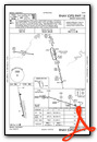
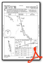
Nearby Airports with Instrument Procedures
| ID | Name | Heading / Distance | ||
|---|---|---|---|---|
 |
KFAT | Fresno Yosemite International Airport | 296° | 14.4 |
|
KFCH | Fresno Chandler Exec Airport | 281° | 18.2 |
|
KVIS | Visalia Municipal Airport | 172° | 21.3 |
|
KHJO | Hanford Municipal Airport | 201° | 22.9 |
|
KTLR | Mefford Field Airport | 168° | 31.4 |
|
KMAE | Madera Municipal Airport | 301° | 37.1 |
|
KPTV | Porterville Municipal Airport | 153° | 42.8 |
|
F34 | Firebaugh Airport | 283° | 50.2 |
|
C80 | New Coalinga Municipal Airport | 233° | 51.0 |
|
KDLO | Delano Municipal Airport | 169° | 56.4 |
|
KMPI | Mariposa-Yosemite Airport | 330° | 57.7 |
|
KMCE | Merced Yosemite Regional Airport | 306° | 63.0 |
Airport Images

By: LawAviator

By: coreytrillo


