Login
Register


CEM
Central Airport
Official FAA Data Effective 2025-12-25 0901Z
Chart Supplement

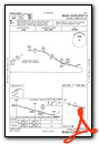
VFR Chart of PACE
Sectional Charts at SkyVector.com
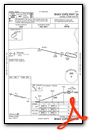
IFR Chart of PACE
Enroute Charts at SkyVector.com
Location Information for PACE
Coordinates: N65°34.44' / W144°46.85'Located 00 miles NNE of Central, Alaska on 97 acres of land. View all Airports in Alaska.
Surveyed Elevation is 936 feet MSL.
Operations Data
|
|
Airport Communications
| CTAF: | 122.900 |
|---|---|
| AWOS-3P at FYU (61.0 N): | 125.8 907-662-2337 |
- APCH/DEP SVC PRVDD BY ANCHORAGE ARTCC (ZAN) ON FREQS 135.0/284.7 (FORT YUKON RCAG).
Nearby Navigation Aids
|
| ||||||||||||
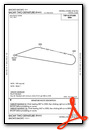
Runway 08/26
| Dimensions: | 2782 x 60 feet / 848 x 18 meters | |
|---|---|---|
| Surface: | Gravel-Dirt in Poor Condition GRASS ON RWY SFC UP TO 12 IN TALL. | |
| Edge Lighting: | Medium Intensity | |
| Runway 08 | Runway 26 | |
| Coordinates: | N65°34.49' / W144°47.39' | N65°34.38' / W144°46.32' |
| Elevation: | 936.8 | 916.2 |
| Traffic Pattern: | Left | Left |
| Runway Heading: | 103° True | 283° True |
| Displaced Threshold: | 121 Feet RY 08 DSPLD THLD MKD WITH BLUE LGTS & REFLECTORS. |
|
| Markings: | Non-Standard in good condition. | Non-Standard in good condition. |
| Obstacles: | 5 ft Brush 0 ft from runway, 80 ft left of center | 2 ft Brush 0 ft from runway, 100 ft right of center |
Services Available
| Fuel: | NONE |
|---|---|
| Transient Storage: | Tiedowns |
| Airframe Repair: | NOT AVAILABLE |
| Engine Repair: | NOT AVAILABLE |
| Bottled Oxygen: | NOT AVAILABLE |
| Bulk Oxygen: | NOT AVAILABLE |
Ownership Information
| Ownership: | Publicly owned | |
|---|---|---|
| Owner: | ALASKA DOT&PF NORTHERN REGION | |
| 2301 PEGER RD | ||
| FAIRBANKS, AK 99709 | ||
| 907-451-2200 | ||
| Manager: | JASON LUDINGTON | |
| 2301 PEGER ROAD | ||
| FAIRBANKS, AK 99709 | ||
| 907-451-5280 | ||
Other Remarks
- THIS AIRPORT HAS BEEN SURVEYED BY THE NATIONAL GEODETIC SURVEY.
- RY COND NOT MONITORED; RECOMMEND VISUAL INSPECTION PRIOR TO LANDING.
- SNOW REMOVAL OPS DURING WINTER MONTIOR - CTAF.
- SUAIS - 125.3/126.3(1-800-758-8723).
- WX CAMERA AVBL ON INTERNET AT HTTPS://WEATHERCAMS.FAA.GOV
- ACTVT MIRL RY 08/26 - CTAF.
Weather Minimums

Instrument Approach Procedure (IAP) Charts
Departure Procedure (DP) Charts
Nearby Airports with Instrument Procedures
| ID | Name | Heading / Distance | ||
|---|---|---|---|---|
 |
PFYU | Fort Yukon Airport | 349° | 61.2 |
|
PACI | Chalkyitsik Airport | 021° | 69.3 |
|
PAWB | Beaver Airport | 307° | 80.0 |
|
PAEI | Eielson AFB Airport | 228° | 80.3 |
|
PAVE | Venetie Airport | 336° | 94.5 |
|
PABI | Allen AAF Airport | 194° | 98.1 |
Airport Images
Do you have a recent image of this airport? Upload it here!


