Login
Register
CLL
Easterwood Field Airport
Official FAA Data Effective 2026-01-22 0901Z
From the Flight Deck
VFR Chart of KCLL
Sectional Charts at SkyVector.com
IFR Chart of KCLL
Enroute Charts at SkyVector.com
Location Information for KCLL
Coordinates: N30°35.28' / W96°21.75'Located 03 miles SW of College Station, Texas on 700 acres of land. View all Airports in Texas.
Surveyed Elevation is 320 feet MSL.
Operations Data
|
|
Airport Communications
| ATIS: | 126.85 |
|---|---|
| ASOS: | Tel. 979-846-1708 |
| EASTERWOOD TOWER: | 118.5 284.7 |
| EASTERWOOD GROUND: | 128.7 284.7 |
| HOUSTON APPROACH: | 134.3 360.85 |
| HOUSTON DEPARTURE: | 134.3 360.85 |
| CLEARANCE DELIVERY: | 128.7 120.4 ;WHEN TWR CLSD |
| EMERG: | 121.5 243.0 |
| CTAF: | 118.500 |
| UNICOM: | 122.950 |
| AWOS-3PT at CFD (7.9 N): | 125.975 979-778-2544 |
| AWOS-3PT at RWV (18.2 W): | 118.35 979-567-6784 |
| AWOS-3PT at 60R (18.4 SE): | 120.925 936-825-0798 |
Nearby Navigation Aids
|
| ||||||||||||||||||||||||||||||||||||||||||||||||||||||||||||
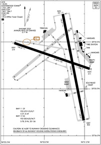
Runway 17/35
| Dimensions: | 7000 x 146 feet / 2134 x 45 meters | |
|---|---|---|
| Surface: | Asphalt-Concrete / Grooved in Excellent Condition FIRST 1850 FT RWY 35 CONC. | |
| Weight Limits: | S-78, D-94, ST-156
PCR VALUE: 300/R/D/W/T
| |
| Edge Lighting: | High Intensity | |
| Runway 17 | Runway 35 | |
| Coordinates: | N30°35.80' / W96°21.77' | N30°34.67' / W96°21.51' |
| Elevation: | 320.6 | 304.3 |
| Traffic Pattern: | Left | Left |
| Runway Heading: | 169° True | 349° True |
| Declared Distances: | TORA:7000 TODA:7000 ASDA:7000 LDA:7000 | TORA:7000 TODA:7000 ASDA:6932 LDA:6932 |
| Markings: | Precision Instrument in good condition. | Precision Instrument in good condition. |
| Glide Slope Indicator | V4R (3.00° Glide Path Angle) | |
| Approach Lights: | MALSR 1,400 Foot Medium-intensity Approach Lighting System with runway alignment indicator lights. | |
| Obstacles: | 42 ft Tree 500 ft from runway, 480 ft right of center | |
Runway 11/29
| Dimensions: | 5158 x 150 feet / 1572 x 46 meters | |
|---|---|---|
| Surface: | Asphalt / Grooved in Excellent Condition | |
| Weight Limits: | S-37, D-49
PCR VALUE: 570/F/D/X/T
| |
| Edge Lighting: | Medium Intensity | |
| Runway 11 | Runway 29 | |
| Coordinates: | N30°35.49' / W96°22.37' | N30°35.21' / W96°21.44' |
| Elevation: | 319.4 | 311.4 |
| Traffic Pattern: | Left | Left |
| Runway Heading: | 109° True | 289° True |
| Declared Distances: | TORA:5158 TODA:5158 ASDA:5158 LDA:5158 | TORA:5158 TODA:5158 ASDA:5158 LDA:5158 |
| Markings: | Non-Precision Instrument in good condition. | Non-Precision Instrument in good condition. |
| Glide Slope Indicator | V4L (3.00° Glide Path Angle) | V4L (3.00° Glide Path Angle) |
| REIL: | Yes | |
| Obstacles: | 40 ft Tree 1180 ft from runway, 400 ft right of center | 18 ft Tree 500 ft from runway, 230 ft left of center |
Services Available
| Fuel: | 100LL (blue), Jet-A, Jet A+ |
|---|---|
| Transient Storage: | Hangars,Tiedowns |
| Airframe Repair: | MAJOR |
| Engine Repair: | MAJOR |
| Bottled Oxygen: | NOT AVAILABLE |
| Bulk Oxygen: | NOT AVAILABLE |
| Other Services: | AVIONICS,CHARTER SERVICE,PILOT INSTRUCTION |
Ownership Information
| Ownership: | Publicly owned | |
|---|---|---|
| Owner: | TEXAS A&M UNIVERSITY | |
| 301 TARROW STREET | ||
| COLLEGE STATION, TX 77840 | ||
| (979) 775-9900 | ||
| Manager: | KEVIN DAVIS | |
| 1 MCKENZIE TERMINAL BLVD, SUITE 112 | ||
| COLLEGE STATION, TX 77845 | ||
| 979-775-9901 | ||
Other Remarks
- ALL RAPID RFL MIL HEL ADZ ATC FOR RAPID RFL OPS & PROCD TO SOUTH RAMP. CTC ASTIN AVN UNICOM 122.95 FOR SVC PRIOR TO LNDG. RAPID RFL IS AVBL 0600-2200 DLY. SPL RQS CSDRD ON CASE BY CASE BASIS.
- FOR CD IF UNA TO CTC ON FSS FREQ, CTC HOUSTON ARTCC AT 281-230-5622.
- ALL ACFT PRKG ON SE RAMP MUST CTC ASTIN AVN FOR SVC OR TRNSP, UNICOM 122.95 OR 979-775-5255.
- (CONTACT PHONE NR) CABBOTT@EASTERWOODAIRPORT.COM
- TURN FEE SKEDD FAR 135 AND ALL FAR 121 OPNS.
- PAEW ADJ ALL RWYS AND TWYS 0600-1600.
- SFC COND NOT RPRTD FM 1700-0500 LCA MON-FRI AND SAT-SUN.
- 0LL FUEL SVC 0600-2200. FOR FUEL AFT HRS PPR CALL 979-775-5255. LATE NIGHT FEE.
- WHEN ATCT CLSD ACTVT MALSR RWY 35; MIRL RWY 11/29; HIRL RWY 17/35 - CTAF. REIL RWY 29 PRESET LOW INTST ONLY.
Weather Minimums
Instrument Approach Procedure (IAP) Charts
Nearby Airports with Instrument Procedures
| ID | Name | Heading / Distance | ||
|---|---|---|---|---|
 |
KCFD | Coulter Field Airport | 011° | 7.8 |
 |
KRWV | Caldwell Municipal Airport | 256° | 18.2 |
 |
60R | Navasota Municipal Airport | 135° | 18.5 |
 |
KLHB | Hearne Municipal Airport | 321° | 21.7 |
 |
11R | Brenham Municipal Airport | 181° | 22.1 |
 |
51R | Madisonville Municipal Airport | 047° | 28.8 |
 |
KGYB | Giddings-Lee County Airport | 232° | 40.7 |
 |
KUTS | Huntsville Municipal Airport | 076° | 41.2 |
 |
3T5 | Fayette Regional Air Center Airport | 217° | 50.9 |
 |
KCXO | Conroe/North Houston Regional Airport | 105° | 51.1 |
 |
T15 | Marlin Airport | 330° | 51.6 |
 |
KDWH | David Wayne Hooks Memorial Airport | 126° | 52.5 |


