Login
Register
3T5
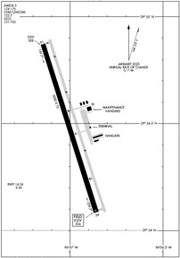
Fayette Regional Air Center Airport
Official FAA Data Effective 2025-12-25 0901Z
VFR Chart of 3T5
Sectional Charts at SkyVector.com
IFR Chart of 3T5
Enroute Charts at SkyVector.com
Location Information for 3T5
Coordinates: N29°54.48' / W96°57.00'Located 02 miles W of La Grange, Texas on 195 acres of land. View all Airports in Texas.
Surveyed Elevation is 324 feet MSL.
Operations Data
|
|
Airport Communications
| AWOS-3: | 124.175 Tel. 979-242-5777 |
|---|---|
| AUSTIN APPROACH: | 120.875 270.25 |
| AUSTIN DEPARTURE: | 120.875 270.25 |
| CTAF: | 122.700 |
| UNICOM: | 122.700 |
| AWOS-3 at GYB (15.9 N): | 119.225 979-542-0382 |
| AWOS-3 at 66R (27.9 SE): | 123.875 979-732-2514 |
| AWOS-3 at T20 (35.2 SW): | 125.875 830-519-4254 |
Nearby Navigation Aids
|
| ||||||||||||||||||||||||||||||||||||||||||||||||||||||||||||
Runway 16/34
| Dimensions: | 5000 x 75 feet / 1524 x 23 meters | |
|---|---|---|
| Surface: | Asphalt in Good Condition | |
| Weight Limits: | S-30 | |
| Edge Lighting: | Medium Intensity | |
| Runway 16 | Runway 34 | |
| Coordinates: | N29°54.87' / W96°57.14' | N29°54.09' / W96°56.86' |
| Elevation: | 307.7 | 324.0 |
| Runway Heading: | 162° True | 342° True |
| Markings: | Non-Precision Instrument in good condition. | Non-Precision Instrument in good condition. |
| Glide Slope Indicator | P2L (3.00° Glide Path Angle) | P2L (3.00° Glide Path Angle) |
| REIL: | Yes | Yes |
| Obstacles: | 65 ft Tree 2525 ft from runway | 60 ft Tree 1460 ft from runway, 140 ft right of center |
Services Available
| Fuel: | 100LL (blue), Jet-A |
|---|---|
| Transient Storage: | Tiedowns |
| Airframe Repair: | NONE |
| Engine Repair: | NONE |
| Bottled Oxygen: | NOT AVAILABLE |
| Bulk Oxygen: | NOT AVAILABLE |
Ownership Information
| Ownership: | Publicly owned | |
|---|---|---|
| Owner: | FAYETTE COUNTY | |
| COUNTY COURTHOUSE | ||
| LA GRANGE, TX 78945 | ||
| 979-968-6469 | ||
| Manager: | DEBRA MADDOX | |
| 850 AIRPORT ROAD | ||
| LA GRANGE, TX 78945 | ||
| 979-242-4056 | ||
Other Remarks
- GCO AVBL ON FREQ 121.725 THRU AUSTIN APCH CTL & FLT SVCS.
- FOR CD CTC AUSTIN APCH AT 512-369-7865.
- 0LL FUEL 24 HRS SELF SERVE. AFTR HRS ATNDT, CALL 979-242-3316 DURING ATND HRS.
- DUSK-DAWN. MIRL RWY 16/34 PRESET LOW INTST; TO INCR INTST ACTVT CTAF.
Weather Minimums
Instrument Approach Procedure (IAP) Charts
Nearby Airports with Instrument Procedures
| ID | Name | Heading / Distance | ||
|---|---|---|---|---|
 |
84R | Smithville Crawford Municipal Airport | 302° | 13.4 |
 |
KGYB | Giddings-Lee County Airport | 354° | 15.7 |
 |
11R | Brenham Municipal Airport | 057° | 35.3 |
 |
T85 | Yoakum Municipal Airport | 195° | 36.9 |
 |
KELA | Eagle Lake Airport | 119° | 37.6 |
 |
50R | Lockhart Municipal Airport | 264° | 37.8 |
 |
KRWV | Caldwell Municipal Airport | 019° | 38.5 |
 |
KAUS | Austin-Bergstrom International Airport | 294° | 41.2 |
 |
KEDC | Austin Exec Airport | 312° | 43.4 |
 |
T74 | Taylor Municipal Airport | 327° | 47.3 |
 |
KHYI | San Marcos Regional Airport | 269° | 47.6 |
 |
KCLL | Easterwood Field Airport | 036° | 50.9 |


