Login
Register


CSM5
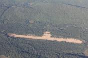
St-Michel-des-Saints Airport
VFR Chart of CSM5
Sectional Charts at SkyVector.com
IFR Chart of CSM5
Enroute Charts at SkyVector.com
Location Information for CSM5
Coordinates: N46°40.85' / W73°59.62'View all Airports in Québec, Canada.
Elevation is 1372 feet MSL.
Magnetic Variation from 2014 is 15° West
Time Zone is UTC-5(4).
Operations Data
|
|
Airport Communications
All Services Bilingual| Aerodrome Traffic Frequency (ATF) | traffic 123.2 5NM 4400 ASL |
|---|
Nearby Navigation Aids
|
| ||||||||||||||||||||||||||||||||||||||||||||||||||||||||||||


Runway 16/34
| Dimensions: | 3000 x 75 feet. | |
|---|---|---|
| Surface: | GRVL | |
| Runway 16 | Runway 34 | |
| Runway Heading: | ||
Runway Conditions Reporting Source
Operator No win maint
Flight Planning
| Instructions | (bil) |
|---|---|
| Flight Information Centre (FIC) | Québec 866-GOMÉTÉO or 866-WXBRIEF (Toll free within Canada) or 866-541-4105 (Toll free within Canada & USA) |
Aerodrome Operator
Municipalité de St-Michel-des-Saints
450-886-4502 Ext 7600 Reg
Nearby Airports with Instrument Procedures
| ID | Name | Heading / Distance | ||
|---|---|---|---|---|
 |
CYFJ | La Macaza/Mont-Tremblant Airport | 258° | 36.4 |
|
CYRQ | Trois-Rivières Airport | 124° | 57.9 |
|
CYMX | Montréal (Mirabel) Airport | 196° | 60.1 |
|
CYUL | Montréal/Pierre Elliott Trudeau International Airport | 186° | 73.4 |
|
CYHU | Montréal/Met (Aéroport Métropolitain Airport | 175° | 73.8 |
|
CSC3 | Drummondville Airport | 141° | 83.3 |
|
CYJN | St-Jean Airport | 175° | 88.4 |
|
CSR3 | Victoriaville (André Fortin) Airport | 126° | 92.2 |
|
CMB7 | Maxville (Bourdon Farm) Airport | 216° | 92.2 |
|
CYND | Ottawa/Gatineau Airport | 238° | 95.6 |
|
CZBM | Bromont (Roland Désourdy) Airport | 162° | 98.5 |
|
CYQB | Québec/Jean Lesage International Airport | 100° | 107.5 |
Airport Images

By: le commandant
By: Cascadeur


