Login
Register
CYRQ
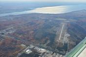
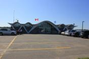
Trois-Rivières Airport
VFR Chart of CYRQ
Sectional Charts at SkyVector.com
IFR Chart of CYRQ
Enroute Charts at SkyVector.com
Location Information for CYRQ
Coordinates: N46°21.10' / W72°40.83'View all Airports in Québec, Canada.
Elevation is 199 feet MSL.
Magnetic Variation from 2013 is 16° West
Time Zone is UTC-5(4).
Operations Data
|
|
Customs Information
AOE/15 888-226-7277 1330-2130Z Mon-Fri exc hols
Airport Communications
All Services Bilingual| Mandatory Frequency (MF) | UNICOM 12-01Z other times traffic 122.35 5NM 3200 ASL (CAR 602.98) |
|---|---|
| Arrival (ARR) | (Bilingual) Montréal Center 128.225 |
| Departure (DEP) | (Bilingual) Montréal Center 128.225 |
| Peripheral Station (PAL) | (Bilingual) Montréal Center 128.225 |
| Automated Weather Observation System (AWOS) | 120.275 (English) 124.825 (French) |
Nearby Navigation Aids
|
| ||||||||||||||||||||||||||||||||||||||||||||||||||||||||||||
Runway 05/23
| Dimensions: | 9006 x 150 feet. | |
|---|---|---|
| Surface: | ||
| Remarks | ASPH | |
| Runway 05 | Runway 23 | |
| Runway Heading: | 047° | 227° |
| Approach Lights | SSALR: High Intensity Approach Lighting System with Runway Alignment Indicator Lights | Omni-Directional Approach Lighting System |
| Glide Slope Indicator | PAPI for aircraft with eye-to-wheel height up to 45 feet. | PAPI for aircraft with eye-to-wheel height up to 45 feet. |
Runway Conditions Reporting Source
Operator 1 hr PN 12-01Z, O/T 2 hr PN, call out chg. CRFI. Win maint 3 hr PN 12-23Z,
O/T 4 hr PN, call out chg. PCN
Services Available
| Fuel Available | 100LL, JA-1 (FSII avbl), SP, HPR ltd hrs (see OPR) O/T 1 hr PN 819-244-0699 call out chg |
|---|---|
| Oil Available | W100, W15W50 |
| Servicing Available | Storage, Minor Repairs, Major Repairs, Extended Parking, Tie Downs, Plug-in |
| Supporting Fluids, Systems, and Oxygen | D & A-ice |
| Jet Aircraft Starting Units (JASU) | Electric start 10/15 |
| Private Advisory | Cjet Aviation 819-330-2538 |
Public Facilities
| Location | Facilities | Remarks |
|---|---|---|
| In Terminal Building | Telephone, Food | 7,8 |
| Within 5 NM | Taxi, Medical Aid, Accomodations, Car Rental |
Flight Planning
| Instructions | (bil) |
|---|---|
| Flight Information Centre (FIC) | Québec 866-GOMÉTÉO or 866-WXBRIEF (Toll free within Canada) or 866-541-4105 (Toll free within Canada & USA) |
| Area Control Centre (ACC) | Montréal 800-633-1353 |
| Weather (WX) | METAR AUTO H24 (see COMM) TAF H24, issue times: 02, 08, 14, 20Z. WxCam |
Aerodrome Operator
Airport 819-377-4382 www.idetr.com/cyrq
12-01Z Mon-Fri, 13-24Z Sat-Sun Mar 16 - May 15;
12-02Z Mon-Fri, 13-01Z Sat-Sun May 16 - Aug 15;
12-01Z Mon-Fri, 13-24Z Sat-Sun Aug 16 - Nov 15;
12-24Z Mon-Fri, 13-23Z Sat-Sun Nov 16 - Mar 15;
O/T 819-244-0699; hols ltd hrs (check NOTAM) Cert
Ldg fees
Nearby Airports with Instrument Procedures
| ID | Name | Heading / Distance | ||
|---|---|---|---|---|
 |
CSC3 | Drummondville Airport | 174° | 32.7 |
 |
CSR3 | Victoriaville (André Fortin) Airport | 130° | 34.4 |
 |
CYHU | Montréal/Met (Aéroport Métropolitain Airport | 227° | 58.8 |
 |
CYQB | Québec/Jean Lesage International Airport | 079° | 59.5 |
 |
CSM3 | Thetford Mines Airport | 122° | 62.0 |
 |
CZBM | Bromont (Roland Désourdy) Airport | 198° | 63.7 |
 |
CYJN | St-Jean Airport | 217° | 68.3 |
 |
CYSC | Sherbrooke Airport | 158° | 68.7 |
 |
CYUL | Montréal/Pierre Elliott Trudeau International Airport | 236° | 69.1 |
 |
CPT9 | Pintendre Airport | 084° | 69.5 |
 |
CYMX | Montréal (Mirabel) Airport | 251° | 69.6 |
 |
CSZ4 | St-Frédéric Airport | 106° | 71.5 |


