Login
Register


CWI
Clinton Municipal Airport
Official FAA Data Effective 2025-12-25 0901Z
Chart Supplement

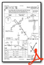
KCWI Airport Diagram
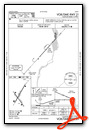
VFR Chart of KCWI
Sectional Charts at SkyVector.com
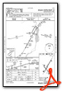
IFR Chart of KCWI
Enroute Charts at SkyVector.com
Location Information for KCWI
Coordinates: N41°49.85' / W90°19.74'Located 06 miles SW of Clinton, Iowa on 556 acres of land. View all Airports in Iowa.
Surveyed Elevation is 707 feet MSL.
Operations Data
|
|
Airport Communications
| AWOS-3PT: | 125.525 Tel. 563-243-8934 |
|---|---|
| QUAD CITY APPROACH: | 125.95 257.8 |
| QUAD CITY DEPARTURE: | 125.95 257.8 |
| CLEARANCE DELIVERY: | 118.5 |
| UNICOM: | 123.075 |
| CTAF: | 123.075 |
| AWOS-3PT at SFY (16.3 NE): | 118.650 815-273-4429 |
| ASOS at DVN (17.6 SW): | 120.175 563-388-2154 |
| ASOS at MLI (24.3 S): | 121.2 309-233-0742 |
- APCH/DEP SVC PRVDD BY CHICAGO ARTCC ON FREQS 118.75/377.05 (MOLINE RCAG) WHEN QUAD CITY APCH CLSD.
Nearby Navigation Aids
|
| ||||||||||||||||||||||||||||||||||||


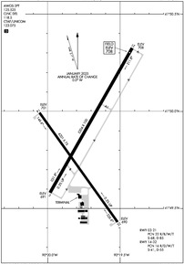
Runway 03/21
RWY 03 CALM WIND RWY. | ||
| Dimensions: | 5204 x 100 feet / 1586 x 30 meters | |
|---|---|---|
| Surface: | Concrete in Good Condition | |
| Weight Limits: | 22 /R/B/W/T, S-68, D-85 | |
| Edge Lighting: | High Intensity | |
| Runway 03 | Runway 21 | |
| Coordinates: | N41°49.58' / W90°19.98' | N41°50.32' / W90°19.41' |
| Elevation: | 690.9 | 707.5 |
| Traffic Pattern: | Left | Left |
| Runway Heading: | 30° True | 210° True |
| Declared Distances: | TORA:5204 TODA:5204 ASDA:5204 LDA:5204 | TORA:5204 TODA:5204 ASDA:5204 LDA:5204 |
| Markings: | Precision Instrument in good condition. | Precision Instrument in good condition. |
| Glide Slope Indicator | V4L (3.00° Glide Path Angle) | |
| Approach Lights: | MALSR 1,400 Foot Medium-intensity Approach Lighting System with runway alignment indicator lights. | |
| REIL: | Yes | |
Runway 14/32
| Dimensions: | 4201 x 75 feet / 1280 x 23 meters | |
|---|---|---|
| Surface: | Concrete in Good Condition | |
| Weight Limits: | 16 /R/D/W/T, S-41, D-55 | |
| Edge Lighting: | Medium Intensity | |
| Runway 14 | Runway 32 | |
| Coordinates: | N41°49.99' / W90°20.05' | N41°49.43' / W90°19.52' |
| Elevation: | 701.4 | 689.9 |
| Traffic Pattern: | Left | Left |
| Runway Heading: | 144° True | 325° True |
| Declared Distances: | TORA:4200 TODA:4200 ASDA:4200 LDA:4200 | TORA:4200 TODA:4200 ASDA:4200 LDA:4200 |
| Markings: | Non-Precision Instrument in good condition. | Non-Precision Instrument in good condition. |
| Glide Slope Indicator | P4L (3.00° Glide Path Angle) | P4L (3.00° Glide Path Angle) |
| REIL: | Yes | |
Services Available
| Fuel: | 100LL (blue), Jet-A |
|---|---|
| Transient Storage: | Hangars,Tiedowns |
| Airframe Repair: | NOT AVAILABLE |
| Engine Repair: | NOT AVAILABLE |
| Bottled Oxygen: | LOW |
| Bulk Oxygen: | NOT AVAILABLE |
| Other Services: | CHARTER SERVICE,PILOT INSTRUCTION,AIRCRAFT RENTAL |
Ownership Information
| Ownership: | Publicly owned | |
|---|---|---|
| Owner: | CITY OF CLINTON | |
| CITY HALL | ||
| CLINTON, IA 52732 | ||
| 563-242-2144 | ||
| Manager: | MARLANA NASS | |
| 2000 S 60TH ST. | ||
| CLINTON, IA 52732 | ||
| 563-242-3292 | ||
Other Remarks
- FOR CD CTC CHICAGO ARTCC AT 630-906-8921.
- ACTVT MALSR RWY 03; REIL RWY 14 & 21; VASI RWY 21; PAPI RWY 14 & 32; HIRL RWY 03/21; MIRL RWY 14/32 - CTAF.
Weather Minimums
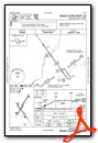
Instrument Approach Procedure (IAP) Charts
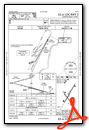

Nearby Airports with Instrument Procedures
| ID | Name | Heading / Distance | ||
|---|---|---|---|---|
 |
KSFY | Tri-Township Airport | 037° | 16.3 |
|
KDVN | Davenport Municipal Airport | 221° | 17.6 |
|
KOQW | Maquoketa Municipal Airport | 305° | 22.6 |
|
KMLI | Quad Cities International Airport | 199° | 24.3 |
|
KSQI | Whiteside County/Jos H Bittorf Field Airport | 099° | 29.8 |
|
8C4 | Mathews Memorial Airport | 264° | 37.2 |
|
KDBQ | Dubuque Regional Airport | 333° | 38.2 |
|
C73 | Dixon Municipal-Charles R Walgreen Field Airport | 089° | 39.6 |
|
KEZI | Kewanee Municipal Airport | 156° | 41.0 |
|
KFEP | Albertus Airport | 053° | 41.7 |
|
KMXO | Monticello Regional Airport | 302° | 44.0 |
|
KMUT | Muscatine Municipal Airport | 233° | 46.2 |


Comments
Cessna 150152 Club Fly In Fun
The support from the City and the local leadership is what makes this a great airport and FBO year after year.
KCWI hosts the best Fly In where you actually get to fly every July. The Cessna 150152 Club.
Pages