Login
Register


DVN
Davenport Municipal Airport
Official FAA Data Effective 2026-02-19 0901Z
Chart Supplement

KDVN Airport Diagram

VFR Chart of KDVN
Sectional Charts at SkyVector.com
IFR Chart of KDVN
Enroute Charts at SkyVector.com
Location Information for KDVN
Coordinates: N41°36.62' / W90°35.30'Located 05 miles N of Davenport, Iowa on 764 acres of land. View all Airports in Iowa.
Surveyed Elevation is 750 feet MSL.
Operations Data
|
|
Airport Communications
| ASOS: | 120.175 Tel. 563-388-2154 |
|---|---|
| QUAD CITY APPROACH: | 125.95 257.8 |
| QUAD CITY DEPARTURE: | 125.95 257.8 |
| CLEARANCE DELIVERY: | 118.35 |
| CTAF: | 123.000 |
| UNICOM: | 123.000 |
| ASOS at MLI (10.4 S): | 121.2 309-233-0742 |
| ATIS at MLI (10.4 S): | 121.2 |
| AWOS-3PT at CWI (17.6 NE): | 125.525 563-243-8934 |
- APCH/DEP SVC PRVDD BY CHICAGO ARTCC ON FREQS 118.75/377.05 (MOLINE RCAG) WHEN QUAD CITY APCH CLSD.
Nearby Navigation Aids
|
| ||||||||||||||||||||||||||||||||||||||||||


Runway 15/33
| Dimensions: | 5511 x 100 feet / 1680 x 30 meters | |
|---|---|---|
| Surface: | Concrete / Grooved in Excellent Condition | |
| Weight Limits: | 29 /R/B/W/U, S-68, D-93, ST-122 | |
| Edge Lighting: | High Intensity | |
| Runway 15 | Runway 33 | |
| Coordinates: | N41°36.92' / W90°35.61' | N41°36.14' / W90°34.99' |
| Elevation: | 750.5 | 743.1 |
| Traffic Pattern: | Left | Left |
| Runway Heading: | 150° True | 330° True |
| Markings: | Precision Instrument in good condition. | Non-Precision Instrument in good condition. |
| Glide Slope Indicator | V4L (3.00° Glide Path Angle) | V4L (3.00° Glide Path Angle) |
| Approach Lights: | MALSR 1,400 Foot Medium-intensity Approach Lighting System with runway alignment indicator lights. | |
| REIL: | Yes | |
| Obstacles: | 19 ft Road 1180 ft from runway | |
Runway 03/21
| Dimensions: | 4001 x 100 feet / 1220 x 30 meters | |
|---|---|---|
| Surface: | Concrete / Grooved in Excellent Condition | |
| Weight Limits: | 29 /R/B/W/U, S-68, D-93, ST-122 | |
| Edge Lighting: | Medium Intensity | |
| Runway 03 | Runway 21 | |
| Coordinates: | N41°36.45' / W90°35.52' | N41°37.02' / W90°35.09' |
| Elevation: | 746.7 | 749.0 |
| Traffic Pattern: | Left | Left |
| Runway Heading: | 30° True | 210° True |
| Markings: | Non-Precision Instrument in good condition. | Non-Precision Instrument in good condition. |
| Glide Slope Indicator | V4L (3.00° Glide Path Angle) | V4L (3.00° Glide Path Angle) |
| REIL: | Yes | Yes |
| Obstacles: | 14 ft Road 375 ft from runway, 250 ft right of center | |
Services Available
| Fuel: | 100LL (blue), Jet-A |
|---|---|
| Transient Storage: | Hangars,Tiedowns |
| Airframe Repair: | MAJOR |
| Engine Repair: | MAJOR |
| Bottled Oxygen: | NONE |
| Bulk Oxygen: | NONE |
| Other Services: | CHARTER SERVICE,PILOT INSTRUCTION,AIRCRAFT RENTAL,AIRCRAFT SALES |
Ownership Information
| Ownership: | Publicly owned | |
|---|---|---|
| Owner: | CITY OF DAVENPORT | |
| 9230 HARRISON STREET | ||
| DAVENPORT, IA 52806 | ||
| 563-391-5650 | ||
| Manager: | THOMAS VESALGA | JACOB SACHLEBEN , OPERATIONS MANAGER 563-391-5650 |
| PUBLIC WORKS 1200 EAST 46TH STREET | ||
| DAVENPORT, IA 52807 | ||
| 563-326-7783 | ||
Other Remarks
- HELICOPTER OPERATIONS ON CTAF OPERG PARALLEL TO RYS FM GRASS AREAS.
- JET A AND 100LL FULL SVC AVBL ON MAIN RAMP IN FRONT OF TRML BUILDING.
- 100LL SELF SVC FUEL AVBL ON E END OF TWY C.
- FOR CD CTC CHICAGO ARTCC AT 630-906-8921.
- CAUTION WILDLIFE INVOF
- RWY 15 DESIGNATED CALM WIND RY.
- TWO WAY RADIO COMMUNICATIONS REQUIRED FOR ALL ACFT CONDUCTING MULTIPLE OPNS.
- EXTSV HVY MIL HEL (CHINOOK) TRNG ON & INVOF OF ARPT; PSBL EXTREME TRUB FM ROTORS.
- ARNG: DSN 431-5510.
- PAEW ANG RAMP LIMITED PARKING 48 HR PPR.
- DUSK-DAWN. ACTVT MIRL RY 03/21 AND HIRL RY 15/33; VASI RYS 03/21 AND 15/33; MALSR RY 15 & REIL RWYS 3/21 AND 33 - CTAF.
Weather Minimums


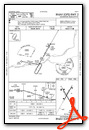
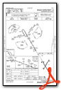
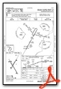
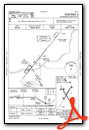
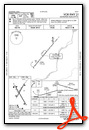
Instrument Approach Procedure (IAP) Charts


Nearby Airports with Instrument Procedures
| ID | Name | Heading / Distance | ||
|---|---|---|---|---|
 |
KMLI | Quad Cities International Airport | 159° | 10.4 |
|
KCWI | Clinton Municipal Airport | 041° | 17.6 |
|
8C4 | Mathews Memorial Airport | 290° | 27.0 |
|
KOQW | Maquoketa Municipal Airport | 345° | 27.2 |
|
KMUT | Muscatine Municipal Airport | 240° | 29.1 |
|
KSFY | Tri-Township Airport | 039° | 33.9 |
|
KEZI | Kewanee Municipal Airport | 130° | 37.2 |
|
C66 | Monmouth Municipal Airport | 182° | 40.9 |
|
KGBG | Harrel W Timmons Galesburg Regional Airport | 169° | 40.9 |
|
KSQI | Whiteside County/Jos H Bittorf Field Airport | 078° | 41.8 |
|
KIOW | Iowa City Municipal Airport | 272° | 43.2 |
|
KMXO | Monticello Regional Airport | 325° | 44.7 |
Airport Images
Do you have a recent image of this airport? Upload it here!


