Login
Register


CYYZ
Toronto/Lester B. Pearson International Airport
VFR Chart of CYYZ
Sectional Charts at SkyVector.com
IFR Chart of CYYZ
Enroute Charts at SkyVector.com
Location Information for CYYZ
Coordinates: N43°40.57' / W79°37.83'View all Airports in Ontario, Canada.
Elevation is 569 feet MSL.
Magnetic Variation is 10° West
Time Zone is UTC-5(4).
Operations Data
|
|
Customs Information
AOE 888-226-7277 General aviation aircraft must clear customs at the fixed base
opr of their choice. Ramp charges may apply.
Airport Communications
| Remote Communications Outlet (RCO) | London Radio 123.275 (FISE) |
|---|---|
| Automated Terminal Information Service (ATIS) | 120.825 |
| Clearance Delivery (CLNC DEL) | 121.3 all dep acft ctc clnc del dur 12-04Z |
| Ground Control (GND) | 119.1 121.65 121.9 |
| Control Tower (TWR) | Toronto 118.35 118.7 (E) (Emergency only 905-676-3588) |
| Arrival (ARR) | 124.475 125.4 132.8 134.175 |
| Departure (DEP) | 127.575 128.8 |
| VFR Advisory (VFR ADV) | 119.3 133.4 |
Nearby Navigation Aids
|
| ||||||||||||||||||||||||||||||||||||||||||||||||||||||||||||


Runway 15L/33R
| Dimensions: | 11050 x 200 feet. | |
|---|---|---|
| Surface: | ||
| Remarks | ASPH | |
| Runway 15L | Runway 33R | |
| Runway Heading: | 147° | 327° |
| Approach Lights | SSALR: High Intensity Approach Lighting System with Runway Alignment Indicator Lights | |
| Glide Slope Indicator | PAPI for aircraft with eye-to-wheel height up to 45 feet. | |
Runway 15R/33L
| Dimensions: | 9088 x 197 feet. | |
|---|---|---|
| Surface: | ||
| Remarks | ASPH | |
| Runway 15R | Runway 33L | |
| Runway Heading: | 147° | 327° |
| Approach Lights | SSALR: High Intensity Approach Lighting System with Runway Alignment Indicator Lights | |
| Glide Slope Indicator | PAPI for aircraft with eye-to-wheel height up to 45 feet. | |
Runway 05/23
| Dimensions: | 11120 x 200 feet. | |
|---|---|---|
| Surface: | ||
| Remarks | ASPH | |
| Runway 05 | Runway 23 | |
| Runway Heading: | 057° | 237° |
| Displaced Threshold: | 135 feet | 686 feet |
| Approach Lights | ALSF-2: Category II/III High Intensity Approach Lighting System. | SSALR: High Intensity Approach Lighting System with Runway Alignment Indicator Lights, ALSF-2: Category II/III High Intensity Approach Lighting System. |
| Glide Slope Indicator | PAPI for aircraft with eye-to-wheel height up to 45 feet. | PAPI for aircraft with eye-to-wheel height up to 45 feet. |
Runway 06L/24R
| Dimensions: | 9697 x 197 feet. | |
|---|---|---|
| Surface: | ||
| Remarks | ASPH | |
| Runway 06L | Runway 24R | |
| Runway Heading: | 057° | 237° |
| Displaced Threshold: | 197 feet | |
| Approach Lights | Runway ID Lights (Strobes), SSALR: High Intensity Approach Lighting System with Runway Alignment Indicator Lights | |
| Glide Slope Indicator | PAPI for aircraft with eye-to-wheel height up to 45 feet. | |
Runway 06R/24L
| Dimensions: | 9000 x 197 feet. | |
|---|---|---|
| Surface: | ||
| Remarks | ASPH RESA: All Rwys 492' Departures from holding bay inner centerlines Rwy 06L/D6, 24R/C5 and 05/H6 subtract 263´ from declared distances. | |
| Runway 06R | Runway 24L | |
| Runway Heading: | 057° | 237° |
| Approach Lights | SSALR: High Intensity Approach Lighting System with Runway Alignment Indicator Lights | |
| Glide Slope Indicator | PAPI for aircraft with eye-to-wheel height up to 45 feet. | |
Runway Conditions Reporting Source
Operator CRFI, PCN
Taxiway Information
Twy D4, D5 south of rwy 06L/24R: Angled rwy hold positions in effect.
Twy K is uncontrolled & is restricted to acft with wingspans 41.15m/135´(B757W) or less &
an Aircraft Load Rating of 9.0 or less. Other acft may be auth with prior appr from opr.
Design spd for C2, B2, H3, D1, D2, D3, D4, D5, D7 & D8 is 50 kt (93 kph). Design spd
for J2, F1, F2, F3 & F4 is 45 kt (85 kph). All other rapid exits designed for an exit
speed of 35 kt (65kph).
Normal Rwy 23 deps are from Twy "H". Rwy 23 deps do not enter Twy "Q" without
specific clearance from ATC. Acft requiring full length must notify gnd ctl on initial
contact.
During CAT II/III arrivals 05 departures shall be from H6
Twys W & Y restricted to acft with wingspans less than 36m.
Apron Information
At all T1, T1 East Hold, T3, Infield & FedEx Apron/Parking areas, all acft must contact
the applicable Apron Advisory prior to engine start at gate, pushback or taxi. Fedex
Apron restricted to acft with wingspans 51.9m/170' or less. Taxilane btwn 3C and 4C restricted to
acft with wingspans less than 36m. Wingspans of 64.9m/213' permitted to Gate C27
Code E. Asphalt apron sfc E of positions 5G and 6F to 101A restricted to acft with
wingspans 28.4m/93´ (DH8-400) or less & an acft load rating of 9.0 or less.
Outer/East loop btwn 7E-8E restricted to acft with wingspans less than 36m and Inner/East
loop btwn 7D-8D restricted to acft with wingspans 79.9m/262' or less. Simultaneous use of
lane 7 & 8 max wingspan 64.9m/213' Code E. Outer/North loop btwn 9C-9D-10D-10C
restricted to acft with wingspans less than 36m. Strict adherence to Taxilane centreline
required btwn DR and DV and on Taxilanes 10 through 12. Taxilane 10 restricted to acft
with wingspans 36m/118' or less. Refer to CAP parking areas (Terminal 1 and
Terminal 1 East Hold) for details. Proceed only to gates assigned by Apron Advisory.
Bombardier Apron: Pvt
SkyService South Apron: Heli ops not auth. Pvt.
Services Available
| Fuel Available | JA, JA-1 (FSII avbl), JB, HPR |
|---|---|
| Oil Available | All |
| Servicing Available | Storage, Minor Repairs, Major Repairs |
| Aircraft Rescue and Fire-fighting | DESIGNATED CAT 9 |
| Supporting Fluids, Systems, and Oxygen | D & A-ice, LHOX |
| Jet Aircraft Starting Units (JASU) | CE16 |
| Private Advisory | Landmark Aviation 122.95 H24; Skycharter Ltd 129.75 1130-08Z Skyservice/Esso Avitat 128.95 H24 |
| Military Contract Fuel | Signature Flight Support (Shell) 905-677-5777 |
Public Facilities
| Location | Facilities | Remarks |
|---|---|---|
| In Terminal Building | Telephone, Food, Taxi, Accomodations, Car Rental | 7 |
| Within 5 NM | Medical Aid |
Flight Planning
| Instructions | Pilots to open/close VFR Flt Pln with London FIC via phone or London rdo 123.275 when practicable. |
|---|---|
| Flight Information Centre (FIC) | London 866-WXBRIEF (Toll free within Canada) or 866-541-4104 (Toll free within Canada & USA) |
| Area Control Centre (ACC) | Toronto 905-676-4590/4591/4592 or 888-217-1241. Flt pln by Fax at 905-676-5044 & include phone numbers where pilot can be reached prior to dep. |
| Weather (WX) | METAR H24. TAF H24, issue times: 00, 03, 06, 09, 12, 15, 18 & 21Z. |
| Direct User Access Terminal (DUAT) | Esso Avitat; Landmark Aviation; Skycharter |
Aerodrome Operator
Greater Toronto Airports Authority 416-776-3056 www.torontopearson.com/en
H24 Cert Ldg fees
Nearby Airports with Instrument Procedures
| ID | Name | Heading / Distance | ||
|---|---|---|---|---|
 |
CYTZ | Toronto/Billy Bishop Toronto City Airport | 115° | 10.6 |
|
CYHM | Hamilton Airport | 213° | 33.0 |
|
CYKF | Kitchener/Waterloo Airport | 258° | 35.1 |
|
CYOO | Toronto/Oshawa Executive Airport Airport | 074° | 35.2 |
|
CYSN | St Catharines/Niagara District Airport | 155° | 35.3 |
|
CYFD | Brantford Airport | 233° | 45.1 |
|
CNV8 | Edenvale Airport | 352° | 48.0 |
|
CYLS | Barrie-Orillia/Lake Simcoe Airport | 013° | 48.7 |
|
CNY3 | Collingwood Airport | 343° | 51.7 |
|
CYSA | Stratford Municipal Airport | 265° | 59.0 |
|
CYPQ | Peterborough Airport | 068° | 64.2 |
|
CYTB | Tillsonburg Airport | 237° | 66.4 |

Airport Images
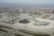
By: jumpstartation


Comments
Control Tower?