Login
Register
E63
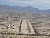
Gila Bend Municipal Airport
Official FAA Data Effective 2025-12-25 0901Z
VFR Chart of E63
Sectional Charts at SkyVector.com
IFR Chart of E63
Enroute Charts at SkyVector.com
Location Information for E63
Coordinates: N32°57.61' / W112°40.42'Located 02 miles E of Gila Bend, Arizona on 232 acres of land. View all Airports in Arizona.
Estimated Elevation is 788 feet MSL.
Operations Data
|
|
Airport Communications
| CTAF: | 122.800 |
|---|---|
| UNICOM: | 122.800 |
| AWOS-3 at BXK (27.5 N): | 119.625 623-386-7627 |
| ATIS at GYR (31.6 NE): | 118.35 |
| ATIS at LUF (37.5 NE): | 134.925 |
- COMMUNICATIONS PRVDD BY PRESCOTT RADIO ON FREQ 122.1R/116.6T (GILA BEND RCO).
Nearby Navigation Aids
|
| ||||||||||||||||||||||||||||||||||||||||||||||||
Runway 04/22
PRIMARY SFC +5-20 FT BRUSH & TREES 100-125 FT S OF CNTRLN. AREA PARL RWY NARROWS TO 30 FT AT CULVERT. | ||
| Dimensions: | 5200 x 75 feet / 1585 x 23 meters | |
|---|---|---|
| Surface: | Asphalt in Good Condition | |
| Weight Limits: | S-12 | |
| Edge Lighting: | Medium Intensity RWY 04/22 AND TWY LIGHTING SYSTEM OUT OF SERVCE INDEF. | |
| Runway 04 | Runway 22 | |
| Coordinates: | N32°57.38' / W112°40.85' | N32°57.84' / W112°39.99' |
| Elevation: | 774.2 | 788.7 |
| Traffic Pattern: | Left | Left |
| Markings: | Non-Precision Instrument in good condition. | Non-Precision Instrument in good condition. |
| Glide Slope Indicator | P2L (3.00° Glide Path Angle) | P2L (3.00° Glide Path Angle) |
| Obstacles: | 17 ft Tree 266 ft from runway, 30 ft right of center CONTROLLING OBSTRUCTION EXCEEDS A 45 DEGREE SLOPE RWY 04, 3-20 FT BRUSH AND TREES 0-200 FT FM THR, 105-125 FT RIGHT OF CNTRLN. 2-4 FT BERM 115 FT RIGHT OF CNTRLN, ENTIRE LENGHT OF RWY. |
16 ft Tree 202 ft from runway, 50 ft left of center RWY 22, 3-15 FT BRUSH, 0- 200 FT FM THR, 60-125 FT LEFT OF CNTRLN. 2-4 FT BRUSH, 0-200 FT FM THR, 20-125 FT RIGHT OF CNTRLN. 4 FT DITCH, 0-200 FT FM THR, 80 FT BOTH SIDES OF CNTRLN. |
Services Available
| Fuel: | 100LL (blue) |
|---|---|
| Transient Storage: | Tiedowns |
| Airframe Repair: | NOT AVAILABLE |
| Engine Repair: | NOT AVAILABLE |
| Bottled Oxygen: | NOT AVAILABLE |
| Bulk Oxygen: | NOT AVAILABLE |
Ownership Information
| Ownership: | Publicly owned | |
|---|---|---|
| Owner: | TOWN OF GILA BEND | |
| PO BOX A | ||
| GILA BEND, AZ 85337 | ||
| 623-810-4662 | ||
| Manager: | COREY DRURY | |
| TOWN OF GILA BEND, DEPT. OF PUB WKS P.O. BOX A | ||
| GILA BEND, AZ 85337 | ||
| 623-810-4662 | ||
Other Remarks
- FOR CD CTC LUKE APCH AT 623-856-7361. IF UNA CTC ALBUQUERQUE ARTCC AT 505-856-4861.
- AREA ALONGSIDE RWY NARROWS TO 30 FT AT CULVERT.
- 0LL SELF SVC H24 WITH CREDIT CARD.
- ACTVT MIRL RWY 04/22. CTAF LIGHTING OTS INDEF.
Nearby Airports with Instrument Procedures
| ID | Name | Heading / Distance | ||
|---|---|---|---|---|
 |
KGYR | Phoenix Goodyear Airport | 028° | 31.5 |
 |
KLUF | Luke AFB Airport | 022° | 37.4 |
 |
KGEU | Glendale Regional Airport | 029° | 38.9 |
 |
P19 | Stellar Airpark Airport | 061° | 43.2 |
 |
KPHX | Phoenix Sky Harbor International Airport | 049° | 43.8 |
 |
KCGZ | Casa Grande Municipal Airport | 090° | 45.8 |
 |
KCHD | Chandler Municipal Airport | 066° | 47.2 |
 |
KDVT | Phoenix Deer Valley Airport | 034° | 52.8 |
 |
KSDL | Scottsdale Airport | 043° | 55.2 |
 |
KIWA | Mesa Gateway Airport | 067° | 55.4 |
 |
KFFZ | Falcon Field Airport | 057° | 56.2 |
 |
P08 | Coolidge Municipal Airport | 090° | 63.0 |


Comments
Gila Bend Fuel
Gila Bend has a self-serve 100LL pump, 2/7/2016 price was $4.95/gal