Login
Register


ELA
Eagle Lake Airport
Official FAA Data Effective 2026-01-22 0901Z
Chart Supplement

VFR Chart of KELA
Sectional Charts at SkyVector.com
IFR Chart of KELA
Enroute Charts at SkyVector.com
Location Information for KELA
Coordinates: N29°36.00' / W96°19.32'Located 01 miles NE of Eagle Lake, Texas on 215 acres of land. View all Airports in Texas.
Surveyed Elevation is 184 feet MSL.
Operations Data
|
|
Airport Communications
| AWOS-3PT: | 128.475 Tel. 979-234-2665 |
|---|---|
| HOUSTON APPROACH: | 124.225 306.975 |
| HOUSTON DEPARTURE: | 124.225 306.975 |
| CTAF: | 122.900 |
| AWOS-3 at 66R (10.3 W): | 123.875 979-732-2514 |
| AWOS-3 at ARM (22.8 SE): | 118.475 979-532-2791 |
| AWOS-3 at TME (25.2 NE): | 119.525 281-574-7296 |
Nearby Navigation Aids
|
| ||||||||||||||||||||||||||||||||||||||||||||||||||||||


Runway 17/35
| Dimensions: | 4280 x 60 feet / 1305 x 18 meters | |
|---|---|---|
| Surface: | Asphalt in Good Condition | |
| Weight Limits: | S-12 | |
| Edge Lighting: | Medium Intensity | |
| Runway 17 | Runway 35 | |
| Coordinates: | N29°36.35' / W96°19.38' | N29°35.65' / W96°19.26' |
| Elevation: | 183.9 | 181.9 |
| Traffic Pattern: | Left | Right |
| Runway Heading: | 171° True | 351° True |
| Markings: | Non-Precision Instrument in good condition. | Non-Precision Instrument in good condition. |
| Glide Slope Indicator | P2L (3.00° Glide Path Angle) | P2L (3.00° Glide Path Angle) |
| Obstacles: | 15 ft Road 201 ft from runway, 69 ft left of center 15 FT RD, 68 FT DSTC, 220 FT R; 15 FT RD, 27 FT DSTC, 250 R. |
|
Services Available
| Fuel: | 100LL (blue), Jet-A |
|---|---|
| Transient Storage: | Tiedowns |
| Airframe Repair: | NOT AVAILABLE |
| Engine Repair: | NOT AVAILABLE |
| Bottled Oxygen: | NONE |
| Bulk Oxygen: | NONE |
| Other Services: | CROP DUSTING SERVICES,PILOT INSTRUCTION |
Ownership Information
| Ownership: | Publicly owned | |
|---|---|---|
| Owner: | CITY OF EAGLE LAKE | |
| PO BOX 38 | ||
| EAGLE LAKE, TX 77434 | ||
| 979-234-2640 | ||
| Manager: | VICTOR SHIMEK | CITY INSPECTOR/ARPT MGR. |
| PO BOX 38 | ||
| EAGLE LAKE, TX 77434 | ||
| 979-234-2640 | ||
Other Remarks
- FOR CD CTC HOUSTON APCH AT 281-443-5844 TO CNL IFR CALL 281-443-5888.
- MIRL RWY 17/35 PRESET LOW; TO INCR INTST ACTVT - CTAF.
Weather Minimums


Instrument Approach Procedure (IAP) Charts
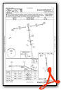
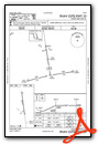
Nearby Airports with Instrument Procedures
| ID | Name | Heading / Distance | ||
|---|---|---|---|---|
 |
KARM | Wharton Regional Airport | 156° | 22.5 |
|
KTME | Houston Exec Airport | 060° | 25.3 |
|
KSGR | Sugar Land Regional Airport | 087° | 34.8 |
|
KIWS | West Houston Airport | 068° | 36.4 |
|
11R | Brenham Municipal Airport | 355° | 37.2 |
|
3T5 | Fayette Regional Air Center Airport | 299° | 37.6 |
|
26R | Jackson County Airport | 200° | 38.4 |
|
KAXH | Houston/Southwest Airport | 097° | 44.6 |
|
KBYY | Bay City Regional Airport | 147° | 44.6 |
|
T85 | Yoakum Municipal Airport | 248° | 46.1 |
|
60R | Navasota Municipal Airport | 013° | 47.2 |
|
KGYB | Giddings-Lee County Airport | 314° | 48.4 |
Airport Images

By: jtrolinger

By: jtrolinger


