Login
Register


BYY
Bay City Regional Airport
Official FAA Data Effective 2026-01-22 0901Z
Chart Supplement

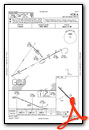
VFR Chart of KBYY
Sectional Charts at SkyVector.com
IFR Chart of KBYY
Enroute Charts at SkyVector.com
Location Information for KBYY
Coordinates: N28°58.39' / W95°51.81'Located 05 miles E of Bay City, Texas on 141 acres of land. View all Airports in Texas.
Surveyed Elevation is 44 feet MSL.
Operations Data
|
|
Airport Communications
| AWOS-3PT: | 118.075 Tel. 979-323-1801 |
|---|---|
| STRYA RNAV DP: | 128.6 360.85 |
| MMALT RNAV DP: | 128.6 360.85 |
| LURIC RNAV DP: | 128.6 360.85 |
| CTAF: | 122.800 |
| UNICOM: | 122.800 |
| STYCK RNAV DP: | 128.6 360.85 |
| WYLSN RNAV DP: | 128.6 360.85 |
| BLTWY RNAV DP: | 128.6 360.85 |
| CESAN STAR: | 121.3 377.1 |
| WAPPL STAR: | 120.05 379.1 |
| AWOS-3 at ARM (22.5 NW): | 118.475 979-532-2791 |
| ASOS at LBX (22.7 E): | 119.925 979-849-3319 |
| ASOS at PSX (25.2 SW): | 118.025 361-972-0101 |
- APCH/DEP CTL SVC PRVDD BY HOUSTON ARTCC (ZHU) ON FREQS 128.6/360.8 (PALACIOS RCAG).
Nearby Navigation Aids
|
| ||||||||||||||||||||||||||||||||||||


Runway 13/31
| Dimensions: | 5107 x 75 feet / 1557 x 23 meters | |
|---|---|---|
| Surface: | Asphalt in Good Condition | |
| Weight Limits: | S-30, D-51, ST-82 | |
| Edge Lighting: | Medium Intensity | |
| Runway 13 | Runway 31 | |
| Coordinates: | N28°58.69' / W95°52.15' | N28°58.10' / W95°51.46' |
| Elevation: | 44.4 | 39.9 |
| Traffic Pattern: | Left | Left |
| Runway Heading: | 134° True | 314° True |
| Markings: | Non-Precision Instrument in good condition. | Non-Precision Instrument in good condition. |
| Glide Slope Indicator | P2L (3.00° Glide Path Angle) | |
| REIL: | Yes | Yes |
| Obstacles: | 25 ft Pole 1170 ft from runway, 300 ft right of center | |
Services Available
| Fuel: | 100LL (blue), Jet-A |
|---|---|
| Transient Storage: | Hangars,Tiedowns |
| Airframe Repair: | NOT AVAILABLE |
| Engine Repair: | NOT AVAILABLE |
| Bottled Oxygen: | NOT AVAILABLE |
| Bulk Oxygen: | NOT AVAILABLE |
| Other Services: | AIR AMBULANCE SERVICES,CHARTER SERVICE,PILOT INSTRUCTION |
Ownership Information
| Ownership: | Publicly owned | |
|---|---|---|
| Owner: | CITY OF BAY CITY | |
| CITY HALL 1901 5TH ST | ||
| BAY CITY, TX 77414 | ||
| 979-245-5311 | ||
| Manager: | JAMES MASON | |
| 3598 NORTH FM 2540 | ||
| BAY CITY, TX 77414 | ||
| 979-244-5037 | ||
Other Remarks
- THIS AIRPORT HAS BEEN SURVEYED BY THE NATIONAL GEODETIC SURVEY.
- TWY REFLECTORS ON ALL TWYS.
- FOR AFT HRS ATTENDANT CALL ARPT NMBR - CALL OUT FEE, TWO HR MIN.
- FOR CD CTC HOUSTON ARTCC AT 281-230-5622.
- ARPT UNATNDD HOLS.
- 0LL 100LL & JET A., 24 HR SELF-SERVICE FUEL. FULL SERV AVAILABLE.
- MIRL RWY 13/31 PRESET LOW INTST SS-SR; TO INCR INTST AND ACTVT REIL RWY 13 & 31 - CTAF.
Weather Minimums


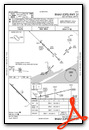
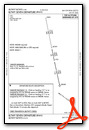
Standard Terminal Arrival (STAR) Charts


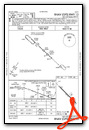
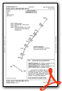
Instrument Approach Procedure (IAP) Charts
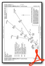
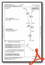
Departure Procedure (DP) Charts


Nearby Airports with Instrument Procedures
| ID | Name | Heading / Distance | ||
|---|---|---|---|---|
 |
KLBX | Texas Gulf Coast Regional Airport | 068° | 22.6 |
|
KARM | Wharton Regional Airport | 317° | 22.7 |
|
KPSX | Palacios Municipal Airport | 234° | 25.2 |
|
26R | Jackson County Airport | 272° | 37.8 |
|
KAXH | Houston/Southwest Airport | 032° | 37.8 |
|
KSGR | Sugar Land Regional Airport | 015° | 40.3 |
|
KELA | Eagle Lake Airport | 327° | 44.6 |
|
KLVJ | Pearland Regional Airport | 044° | 46.3 |
|
KPKV | Calhoun County Airport | 246° | 47.2 |
|
KTME | Houston Exec Airport | 357° | 49.8 |
|
KHOU | William P Hobby Airport | 037° | 50.7 |
|
KIWS | West Houston Airport | 011° | 51.5 |
Airport Images
Do you have a recent image of this airport? Upload it here!


