Login
Register


EZM
Heart of Georgia Regional Airport
Official FAA Data Effective 2025-12-25 0901Z
Chart Supplement

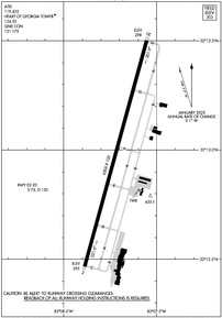
KEZM Airport Diagram
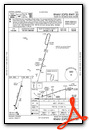
VFR Chart of KEZM
Sectional Charts at SkyVector.com
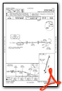
IFR Chart of KEZM
Enroute Charts at SkyVector.com
Location Information for KEZM
Coordinates: N32°12.98' / W83°7.72'Located 03 miles E of Eastman, Georgia on 451 acres of land. View all Airports in Georgia.
Surveyed Elevation is 303 feet MSL.
Operations Data
|
|
Airport Communications
| ATIS: | 119.425 |
|---|---|
| AWOS-3: | 119.425 Tel. 478-374-9979 |
| HEART OF GEORGIA TOWER: | 124.55 |
| HEART OF GEORGIA GROUND: | 121.175 |
| JACKSONVILLE ARTCC APPROACH: | 388.2 ;7000 FT & ABV |
| JACKSONVILLE ARTCC DEPARTURE: | 388.2 ;7000 FT & ABV |
| CTAF: | 124.550 |
| UNICOM: | 122.950 |
| AWOS-3PT at 48A (13.4 NW): | 120.975 478-271-5897 |
| AWOS-3PT at MQW (14.5 SE): | 120.000 229-868-7472 |
| AWOS-3 at DBN (22.1 N): | 118.425 478-277-9051 |
- APCH/DEP SVC PRVDD BY JACKSONVILLE ARTCC ON FREQS 127.575/269.025 (ALMA RCAG).
Nearby Navigation Aids
|
| ||||||||||||||||||||||||||||||||||||||||||||||||||||||||||||


Runway 02/20
| Dimensions: | 6506 x 100 feet / 1983 x 30 meters | |
|---|---|---|
| Surface: | Asphalt / Grooved in Excellent Condition | |
| Weight Limits: | S-75, D-120 | |
| Edge Lighting: | High Intensity | |
| Runway 02 | Runway 20 | |
| Coordinates: | N32°12.47' / W83°7.89' | N32°13.50' / W83°7.55' |
| Elevation: | 295.1 | 298.0 |
| Traffic Pattern: | Left | Left |
| Runway Heading: | 15° True | 195° True |
| Markings: | Precision Instrument in good condition. | Precision Instrument in good condition. |
| Glide Slope Indicator | P4L (3.00° Glide Path Angle) | P4L (3.00° Glide Path Angle) |
| Approach Lights: | MALSR 1,400 Foot Medium-intensity Approach Lighting System with runway alignment indicator lights. | |
| REIL: | Yes | |
| Obstacles: | 81 ft Trees 2277 ft from runway, 520 ft right of center 10 FT TREES, 363 FT RIGHT OF CNTRLN AT THLD. |
|
Services Available
| Fuel: | 100LL (blue), Jet A+ |
|---|---|
| Transient Storage: | Tiedowns |
| Airframe Repair: | MAJOR |
| Engine Repair: | MAJOR |
| Bottled Oxygen: | NONE |
| Bulk Oxygen: | NONE |
| Other Services: | PILOT INSTRUCTION,AIRCRAFT RENTAL,AIRCRAFT SALES |
Ownership Information
| Ownership: | Publicly owned | |
|---|---|---|
| Owner: | HEART OF GA REG APT AUTH | |
| 317 AIRPORT RD. | ||
| EASTMAN, GA 31023 | ||
| 478-220-5091 | TWR PHONE 478-448-4713. MGR CELL PHONE 478-231-8305. | |
| Manager: | JEFF FORDHAM | |
| 317 AIRPORT RD. | ||
| EASTMAN, GA 31023 | ||
| 478-220-5091 | TWR PHONE: 478-448-4713. MGR CELL PHONE 478-231-8305 | |
Other Remarks
- FLT TRNG IN AREA.
- DEER AND OTR WILDLIFE INVOF ARPT.
- CTAF & TWR FREQ - 124.55.
- FOR CD WHEN ATCT IS CLSD CTC JACKSONVILLE ARTCC AT 904-845-1592.
- 0LL 24 HR SELF-FUELING WITH CREDIT CARD.
- ACTVT MALSR RWY 02; REIL RWY 20; PAPI RWY 02 & 20; HIRL RWY 02/20 - CTAF.
- DUSK-2400.
Weather Minimums
Instrument Approach Procedure (IAP) Charts

Nearby Airports with Instrument Procedures
| ID | Name | Heading / Distance | ||
|---|---|---|---|---|
 |
48A | Cochran Airport | 325° | 13.4 |
|
KMQW | Telfair-Wheeler Airport | 119° | 14.6 |
|
KDBN | W H 'Bud' Barron Airport | 019° | 22.1 |
|
KAZE | Hazlehurst Airport | 128° | 31.5 |
|
KFZG | Fitzgerald Municipal Airport | 192° | 32.7 |
|
KWRB | Robins AFB Airport | 317° | 34.6 |
|
KCKF | Crisp County-Cordele Airport | 247° | 35.6 |
|
KPXE | Perry-Houston County Airport | 298° | 36.9 |
|
KVDI | Vidalia Regional Airport | 091° | 38.6 |
|
KMCN | Middle Georgia Regional Airport | 317° | 38.9 |
|
75J | Turner County Airport | 219° | 40.8 |
|
KMAC | Macon Downtown Airport | 328° | 42.4 |
Airport Images
Do you have a recent image of this airport? Upload it here!


