Login
Register


AZE
Hazlehurst Airport
Official FAA Data Effective 2026-01-22 0901Z
Chart Supplement

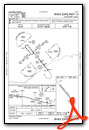
VFR Chart of KAZE
Sectional Charts at SkyVector.com
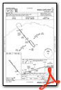
IFR Chart of KAZE
Enroute Charts at SkyVector.com
Location Information for KAZE
Coordinates: N31°53.11' / W82°38.87'Located 03 miles NW of Hazlehurst, Georgia on 190 acres of land. View all Airports in Georgia.
Surveyed Elevation is 255 feet MSL.
Operations Data
|
|
Airport Communications
| AWOS-3: | 119.125 Tel. (912) 375-0650 |
|---|---|
| CTAF: | 122.800 |
| UNICOM: | 122.800 |
| AWOS-3PT at BHC (16.8 SE): | 118.2 912-705-5865 |
| AWOS-3PT at MQW (17.4 NW): | 120.000 229-868-7472 |
| ASOS at AMG (22.2 S): | 118.325 912-632-8738 |
- APCH/DEP SVC PRVDD BY JACKSONVILLE ARTCC ON FREQS 127.575/269.025 (ALMA RCAG).
Nearby Navigation Aids
|
| ||||||||||||||||||||||||||||||||||||||||||||||||||||||||||||


Runway 15/33
| Dimensions: | 5012 x 75 feet / 1528 x 23 meters | |
|---|---|---|
| Surface: | Asphalt in Good Condition | |
| Weight Limits: | S-30 | |
| Edge Lighting: | Medium Intensity | |
| Runway 15 | Runway 33 | |
| Coordinates: | N31°53.43' / W82°39.18' | N31°52.79' / W82°38.57' |
| Elevation: | 221.0 | 250.2 |
| Traffic Pattern: | Left | Left |
| Runway Heading: | 141° True | 321° True |
| Markings: | Non-Precision Instrument in good condition. | Non-Precision Instrument in good condition. |
| Glide Slope Indicator | P2L (3.00° Glide Path Angle) | P2L (3.00° Glide Path Angle) |
| REIL: | Yes | Yes |
| Obstacles: | 45 ft Tree 861 ft from runway, 162 ft right of center | |
Services Available
| Fuel: | 100LL (blue), Jet A+ |
|---|---|
| Transient Storage: | Hangars,Tiedowns |
| Airframe Repair: | MINOR |
| Engine Repair: | MINOR |
| Bottled Oxygen: | NONE |
| Bulk Oxygen: | NONE |
Ownership Information
| Ownership: | Publicly owned | |
|---|---|---|
| Owner: | CITY OF HAZLEHURST | |
| 86 S CROMARTIE ST | ||
| HAZELHURST, GA 31539 | ||
| 912-347-8183 | ||
| Manager: | CODY WHITE | |
| 528 BURKETTS FERRY ROAD | ||
| HAZLEHURST, GA 31539 | ||
| 912-347-8183 | ||
Other Remarks
- DEER & WILDLIFE ON AND INVOF ARPT.
- FOR CD CTC JACKSONVILLE ARTCC AT 904-845-1592.
- 0LL FUEL 24 HR CREDIT CARD SVC AVBL.
- ACTVT REIL RWY 14 & 32; PAPI RWY 32; MIRL RWY 14/32- CTAF.
Weather Minimums

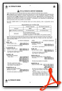
Instrument Approach Procedure (IAP) Charts
Nearby Airports with Instrument Procedures
| ID | Name | Heading / Distance | ||
|---|---|---|---|---|
 |
KBHC | Baxley Municipal Airport | 128° | 16.6 |
|
KMQW | Telfair-Wheeler Airport | 317° | 17.3 |
|
KAMG | Bacon County Airport | 160° | 22.1 |
|
KVDI | Vidalia Regional Airport | 037° | 23.2 |
|
KDQH | Douglas Municipal Airport | 204° | 26.8 |
|
KRVJ | Swinton Smith Field At Reidsville Municipal Airport | 067° | 27.3 |
|
KEZM | Heart of Georgia Regional Airport | 309° | 31.5 |
|
KFZG | Fitzgerald Municipal Airport | 249° | 34.1 |
|
KAYS | Waycross-Ware County Airport | 161° | 40.3 |
|
KMHP | John Edwin Jones Sr Field/Metter Municipal Airport | 044° | 41.1 |
|
KCWV | Claxton-Evans County Airport | 064° | 43.8 |
|
KJES | Jesup-Wayne County Airport | 116° | 43.9 |
Airport Images
Do you have a recent image of this airport? Upload it here!


