Login
Register


F41
Ennis Municipal Airport
Official FAA Data Effective 2026-02-19 0901Z
Chart Supplement

VFR Chart of F41
Sectional Charts at SkyVector.com
IFR Chart of F41
Enroute Charts at SkyVector.com
Location Information for F41
Coordinates: N32°19.78' / W96°39.83'Located 02 miles W of Ennis, Texas on 30 acres of land. View all Airports in Texas.
Surveyed Elevation is 500 feet MSL.
Operations Data
|
|
Airport Communications
| LONE STAR APPROACH: | 125.2 343.65 |
|---|---|
| LONE STAR DEPARTURE: | 125.2 343.65 |
| CTAF: | 122.900 |
| FINGR STAR: | 124.3 125.275 282.275 308.4 |
| BOTCH DP: | 125.2 343.65 |
| SLANT STAR: | 125.025 125.275 308.4 |
| JFRYE STAR: | 118.1 306.95 |
| EESAT STAR: | 125.025 125.275 308.4 |
| SWVAY STAR: | 135.975 379.9 |
| GARLAND DP: | 125.2 343.65 |
| NANDR RNAV DP: | 125.2 343.65 |
| GREGS STAR: | 118.1 306.95 |
| LOADS STAR: | 125.025 125.275 308.4 |
| HERBZ STAR: | 118.1 306.95 |
| AWOS-3P at JWY (14.8 NW): | 119.575 972-227-0471 |
| AWOS-3PT at LNC (15.1 N): | 118.975 972-227-0471 |
| ASOS at CRS (22.5 SE): | 120.675 903-872-9321 |
Nearby Navigation Aids
|
| ||||||||||||||||||||||||||||||||||||||||||||||||||||||||||||


Runway 16/34
| Dimensions: | 4012 x 50 feet / 1223 x 15 meters | |
|---|---|---|
| Surface: | Asphalt in Poor Condition SFC CRACKING, LOOSE STONES. | |
| Weight Limits: | S-18 | |
| Edge Lighting: | Medium Intensity | |
| Runway 16 | Runway 34 | |
| Coordinates: | N32°20.10' / W96°39.96' | N32°19.47' / W96°39.71' |
| Elevation: | 500.2 | 477.0 |
| Traffic Pattern: | Right | Left |
| Runway Heading: | 161° True | 341° True |
| Displaced Threshold: | 254 Feet | |
| Markings: | Basic in fair condition. | Basic in fair condition. |
| Glide Slope Indicator | P2L (3.00° Glide Path Angle) | P2L (3.00° Glide Path Angle) |
| REIL: | Yes | Yes |
| Obstacles: | 5 ft Ground 201 ft from runway, 86 ft left of center RISING GROUND 0 TO 5 FT FROM 0-199 FT DSTC, 88 FT L. |
27 ft Power Line 1125 ft from runway APCH SLOPE 25:1 TO DSPLCD THR OVR 15 FT BRUSH, 382 FT DSTC. 20 FT BRUSH, 0-130 FT DSTC, ACRS APCH. |
Services Available
| Fuel: | 100LL (blue), Jet-A |
|---|---|
| Transient Storage: | Tiedowns |
| Airframe Repair: | MAJOR |
| Engine Repair: | MAJOR |
| Bottled Oxygen: | NONE |
| Bulk Oxygen: | NONE |
| Other Services: | PARACHUTE JUMP ACTIVITY |
Ownership Information
| Ownership: | Publicly owned | |
|---|---|---|
| Owner: | CITY OF ENNIS | |
| 107 N SHERMAN ST, PO BOX 220 | ||
| ENNIS, TX 75119-0220 | ||
| 972-875-1234 | ||
| Manager: | ANDREA WECKMUELLER-BEHRINGER | CITY/ARPT MGR. |
| 107 N SHERMAN ST, P O BOX 220 | ||
| ENNIS, TX 75119-0220 | ||
| 972-875-4279 | ||
Other Remarks
- BIRDS ON AND INVOF ARPT.
- FOR CD CTC LONE STAR APCH AT 972-615-2799.
- 0LL FUEL SELF SERVE.
- ACTVT REIL RWY 16 & 34; PAPI RWY 16 & 34; MIRL RWY 16/34, PRESET LOW INTST - CTAF.
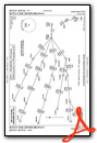
Weather Minimums

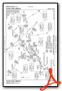
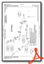
Standard Terminal Arrival (STAR) Charts


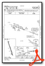
Instrument Approach Procedure (IAP) Charts
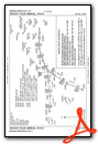
Departure Procedure (DP) Charts


Nearby Airports with Instrument Procedures
| ID | Name | Heading / Distance | ||
|---|---|---|---|---|
 |
KJWY | Mid-Way Regional Airport | 301° | 14.8 |
|
KLNC | Lancaster Regional Airport | 349° | 15.1 |
|
KCRS | C David Campbell Field-Corsicana Municipal Airport | 143° | 22.5 |
|
KRBD | Dallas Exec Airport | 333° | 23.5 |
|
KHQZ | Mesquite Metro Airport | 015° | 25.9 |
|
KINJ | Hillsboro Municipal Airport | 236° | 26.5 |
|
KGPM | Grand Prairie Municipal Airport | 318° | 29.4 |
|
KGKY | Arlington Municipal Airport | 312° | 29.6 |
|
KTRL | Terrell Municipal Airport | 041° | 30.3 |
|
KDAL | Dallas Love Field Airport | 343° | 32.3 |
|
KFWS | Fort Worth Spinks Airport | 293° | 35.6 |
|
F46 | Ralph M Hall/Rockwall Municipal Airport | 017° | 37.8 |
Airport Images
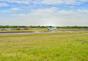
By: Gussan

By: jahangiriali


