Login
Register


HSP
Ingalls Field Airport
Official FAA Data Effective 2026-01-22 0901Z
Chart Supplement

VFR Chart of KHSP
Sectional Charts at SkyVector.com
IFR Chart of KHSP
Enroute Charts at SkyVector.com
Location Information for KHSP
Coordinates: N37°57.09' / W79°50.03'Located 03 miles S of Hot Springs, Virginia on 352 acres of land. View all Airports in Virginia.
Surveyed Elevation is 3792 feet MSL.
Operations Data
|
|
Airport Communications
| AWOS-3: | 118.8 Tel. 540-839-5974 |
|---|---|
| CTAF: | 123.000 |
| UNICOM: | 123.000 |
| AWOS-3PT at LWB (27.4 W): | 304-645-4533 |
| ATIS at LWB (27.4 W): | 121.4 |
| ATIS at ROA (38.2 S): | 132.375 |
- APCH/DEP SVC PRVDD BY WASHINGTON ARTCC ON FREQS 134.4/353.9 (BUENA VISTA RCAG).
Nearby Navigation Aids
|
| ||||||||||||||||||||||||||||||||||||||||||||||||||||||||||||


Runway 07/25
| Dimensions: | 5600 x 100 feet / 1707 x 30 meters | |
|---|---|---|
| Surface: | Asphalt / Grooved in Fair Condition | |
| Weight Limits: | S-65, D-160 | |
| Edge Lighting: | High Intensity | |
| Runway 07 | Runway 25 | |
| Coordinates: | N37°56.85' / W79°50.53' | N37°57.33' / W79°49.53' |
| Elevation: | 3790.2 | 3762.9 |
| Traffic Pattern: | Left | Left |
| Runway Heading: | 59° True | 239° True |
| Markings: | Precision Instrument in good condition. | Precision Instrument in good condition. |
| Glide Slope Indicator | P4R (3.00° Glide Path Angle) | P4L (3.00° Glide Path Angle) |
| REIL: | Yes | |
| Obstacles: | 27 ft Trees 345 ft from runway, 11 ft right of center | |
Services Available
| Fuel: | 100LL (blue), Jet A+ |
|---|---|
| Transient Storage: | Hangars,Tiedowns |
| Airframe Repair: | NONE |
| Engine Repair: | NONE |
| Bottled Oxygen: | NONE |
| Bulk Oxygen: | NONE |
Ownership Information
| Ownership: | Publicly owned | |
|---|---|---|
| Owner: | BATH COUNTY ARPT AUTH | |
| 6240 AIRPORT ROAD | ||
| HOT SPRINGS, VA 24445 | ||
| 540-839-5326 | ||
| Manager: | PARKE KERSHNER | |
| 6240 AIRPORT ROAD | ||
| HOT SPRINGS, VA 24445 | ||
| 540-839-5326 | ||
Other Remarks
- WILDLIFE, INCLUDING BEAR, ON & INVOF ARPT.
- BE ADVISED LOW PASS TO CHECK/CLEAR WILDLIFE WHEN ARPT UNATNDD.
- FOR CD CTC WASHINGTON ARTCC AT 703-771-3587.
- ACTVT REIL RWY 25, PAPI RWYS 07 & 25, HIRL RWY 07/25 & TWY LGTS - CTAF.
Weather Minimums

Instrument Approach Procedure (IAP) Charts


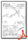
Nearby Airports with Instrument Procedures
| ID | Name | Heading / Distance | ||
|---|---|---|---|---|
 |
KLWB | Greenbrier Valley Airport | 258° | 27.4 |
|
KROA | Roanoke/Blacksburg Regional (Woodrum Field) Airport | 190° | 38.1 |
|
W13 | Eagle's Nest Airport | 079° | 42.8 |
|
W90 | New London Airport | 149° | 47.1 |
|
KSHD | Shenandoah Valley Regional Airport | 066° | 48.2 |
|
KLYH | Lynchburg Regional/Preston Glenn Field Airport | 141° | 48.1 |
|
KVBW | Bridgewater Air Park Airport | 058° | 48.3 |
|
W24 | Falwell Airport | 135° | 48.3 |
|
KSXL | Summersville Airport | 289° | 51.9 |
|
W91 | Smith Mountain Lake Airport | 167° | 51.9 |
|
KBCB | Virginia Tech/Montgomery Exec Airport | 211° | 52.3 |
|
KEKN | Elkins/Randolph County (Jennings Randolph Field) Airport | 358° | 56.2 |
Airport Images

By: Big Orange Bird

By: Big Orange Bird


