Login
Register


VBW
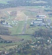
Bridgewater Air Park Airport
Official FAA Data Effective 2025-12-25 0901Z
Chart Supplement

VFR Chart of KVBW
Sectional Charts at SkyVector.com
IFR Chart of KVBW
Enroute Charts at SkyVector.com
Location Information for KVBW
Coordinates: N38°21.92' / W78°57.54'Located 01 miles SE of Bridgewater, Virginia on 90 acres of land. View all Airports in Virginia.
Estimated Elevation is 1165 feet MSL.
Operations Data
|
|
Airport Communications
| AWOS-3: | 119.55 Tel. 540-828-2076 |
|---|---|
| POTOMAC APPROACH: | 132.85 323.125 |
| POTOMAC DEPARTURE: | 132.85 323.125 |
| UNICOM: | 122.700 |
| CTAF: | 122.700 |
| AWOS-3 at SHD (6.9 SE): | 124.925 540-234-0110 |
| AWOS-3PT at W13 (17.2 S): | 118.625 540-941-7570 |
| AWOS-3 at 8W2 (21.0 NE): | 118.175 540-740-3801 |
Nearby Navigation Aids
|
| ||||||||||||||||||||||||||||||||||||||||||||||||||||||||||||


Runway 15/33
| Dimensions: | 4034 x 60 feet / 1230 x 18 meters | |
|---|---|---|
| Surface: | Asphalt in Good Condition | |
| Weight Limits: | S-22 | |
| Edge Lighting: | Medium Intensity | |
| Runway 15 | Runway 33 | |
| Coordinates: | N38°22.18' / W78°57.79' | N38°21.65' / W78°57.28' |
| Elevation: | 1156.8 | 1162.6 |
| Traffic Pattern: | Left | Left |
| Runway Heading: | 143° True | 323° True |
| Displaced Threshold: | 145 Feet | |
| Markings: | Non-Precision Instrument in fair condition. | Non-Precision Instrument in fair condition. |
| Obstacles: | 11 ft Tree 298 ft from runway, 207 ft right of center | 1 ft Fence 207 ft from runway, 50 ft right of center RWY 33 2 FT FENCE POST 70 FT FM THR, 27FT R OF CNTRLN. |
Services Available
| Fuel: | Jet A+ |
|---|---|
| Transient Storage: | Tiedowns |
| Airframe Repair: | NOT AVAILABLE |
| Engine Repair: | NOT AVAILABLE |
| Bottled Oxygen: | NOT AVAILABLE |
| Bulk Oxygen: | NOT AVAILABLE |
Ownership Information
| Ownership: | Privately Owned | |
|---|---|---|
| Owner: | ROCKINGHAM AVIATION CORP | |
| PO BOX 7 | ||
| BRIDGEWATER, VA 22812 | ||
| 540-828-3214 | ||
| Manager: | AARON LORSON | |
| PO BOX 7 | ||
| BRIDGEWATER, VA 22812 | ||
| 540-828-6070 | ||
Other Remarks
- FOR CD CTC POTOMAC APCH AT 866-640-4124.
- ACTVT MIRL RWY 15/33 - CTAF.
Weather Minimums

Instrument Approach Procedure (IAP) Charts

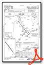
Nearby Airports with Instrument Procedures
| ID | Name | Heading / Distance | ||
|---|---|---|---|---|
 |
KSHD | Shenandoah Valley Regional Airport | 154° | 6.8 |
|
W13 | Eagle's Nest Airport | 177° | 17.3 |
|
8W2 | New Market Airport | 034° | 21.0 |
|
KCHO | Charlottesville-Albemarle Airport | 119° | 27.5 |
|
KLUA | Luray Caverns Airport | 049° | 28.1 |
|
W99 | Grant County Airport | 346° | 38.7 |
|
KGVE | Gordonsville Municipal Airport | 108° | 39.5 |
|
KOMH | Orange County Airport | 099° | 43.7 |
|
KFRR | Front Royal-Warren County Airport | 044° | 46.9 |
|
KHSP | Ingalls Field Airport | 239° | 48.3 |
|
KLKU | Louisa County/Freeman Field Airport | 114° | 51.4 |
|
KCJR | Culpeper Regional Airport | 079° | 52.7 |