Login
Register
LWB
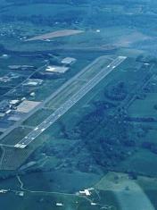
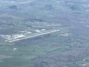
Greenbrier Valley Airport
Official FAA Data Effective 2026-01-22 0901Z
VFR Chart of KLWB
Sectional Charts at SkyVector.com
IFR Chart of KLWB
Enroute Charts at SkyVector.com
Location Information for KLWB
Coordinates: N37°51.50' / W80°23.97'Located 03 miles N of Lewisburg, West Virginia on 472 acres of land. View all Airports in West Virginia.
Surveyed Elevation is 2301 feet MSL.
Operations Data
|
|
Airport Communications
| ATIS: | 121.4 |
|---|---|
| AWOS-3PT: | Tel. 304-645-4533 |
| LEWISBURG TOWER: | 118.9 |
| LEWISBURG GROUND: | 121.9 |
| UNICOM: | 122.950 |
| CTAF: | 118.900 |
| AWOS-3 at HSP (27.6 E): | 118.8 540-839-5974 |
| ASOS at BKW (34.6 W): | 121.55 304-362-0292 |
| ATIS at ROA (37.8 SE): | 132.375 |
- APCH/DEP SVC PRVDD BY WASHINGTON ARTCC ON FREQS 134.4/353.9 (BUENA VISTA RCAG).
- WHEN ATCT CLSD CLEARANCE DELIVERY PRVDD BY WASHINGTON ARTCC ON FREQ 125.725 (LEWISBURG RCAG).
- IF UNABLE TO CONTACT WASHINGTON CENTER ON 134.4, CONTACT WASHINGTON CENTER ON 125.725.
Nearby Navigation Aids
|
| ||||||||||||||||||||||||||||||||||||||||||||||||||||||||||||
Runway 04/22
| Dimensions: | 7003 x 150 feet / 2135 x 46 meters | |
|---|---|---|
| Surface: | Asphalt / Grooved in Good Condition | |
| Weight Limits: | S-90, D-120, ST-160
PCR VALUE: 360/F/D/X/T
| |
| Edge Lighting: | High Intensity | |
| Runway 04 | Runway 22 | |
| Coordinates: | N37°51.03' / W80°24.39' | N37°51.97' / W80°23.55' |
| Elevation: | 2287.3 | 2292.5 |
| Traffic Pattern: | Left | Left |
| Runway Heading: | 35° True | 215° True |
| Declared Distances: | TORA:7003 TODA:7003 ASDA:7003 LDA:7003 | TORA:7003 TODA:7003 ASDA:7003 LDA:7003 |
| Markings: | Precision Instrument in good condition. | Non-Precision Instrument in good condition. |
| Glide Slope Indicator | P4L (3.00° Glide Path Angle) | |
| Approach Lights: | MALSR 1,400 Foot Medium-intensity Approach Lighting System with runway alignment indicator lights. | |
| REIL: | Yes | |
Services Available
| Fuel: | 100LL (blue), Jet-A |
|---|---|
| Transient Storage: | Hangars,Tiedowns |
| Airframe Repair: | MINOR |
| Engine Repair: | MINOR |
| Bottled Oxygen: | NONE |
| Bulk Oxygen: | NONE |
| Other Services: | CARGO HANDLING SERVICES,CHARTER SERVICE,PILOT INSTRUCTION,AIRCRAFT RENTAL,AIRCRAFT SALES |
Ownership Information
| Ownership: | Publicly owned | |
|---|---|---|
| Owner: | GREENBRIER CO ARPT AUTH | |
| 584 AIRPORT RD, SUITE 1 | ||
| LEWISBURG, WV 24901 | ||
| 304-645-3961 | ||
| Manager: | MARTHA LIVESAY | |
| 584 AIRPORT RD BOX 1 | ||
| LEWISBURG, WV 24901 | ||
| 304-646-7382 | MGR CELL: 304-646-7382 | |
Other Remarks
- BIRDS & DEER ON & INVOF ARPT.
- USE CTAF 118.9 WHEN TWR CLSD. FREQ 121.5 NOT AVBL AT TWR.
- ACTVT MALSR RWY 04; REIL RWY 22; PAPI RWY 22; HIRL RWY 04/22; TWY LGTS - CTAF.
Weather Minimums
Instrument Approach Procedure (IAP) Charts
Nearby Airports with Instrument Procedures
| ID | Name | Heading / Distance | ||
|---|---|---|---|---|
 |
KHSP | Ingalls Field Airport | 078° | 27.4 |
 |
KSXL | Summersville Airport | 315° | 31.6 |
 |
KBKW | Raleigh County Memorial Airport | 263° | 34.7 |
 |
KROA | Roanoke/Blacksburg Regional (Woodrum Field) Airport | 147° | 37.8 |
 |
KBCB | Virginia Tech/Montgomery Exec Airport | 180° | 38.9 |
 |
KPSK | New River Valley Airport | 197° | 45.2 |
 |
48I | Braxton County Airport | 346° | 51.1 |
 |
KBLF | Mercer County Airport | 229° | 51.2 |
 |
I16 | Kee Field Airport | 254° | 57.3 |
 |
W91 | Smith Mountain Lake Airport | 139° | 59.2 |
 |
W90 | New London Airport | 124° | 61.7 |
 |
KCRW | West Virginia International Yeager Airport | 299° | 64.5 |


