Login
Register


I08
Cabin Creek USFS Airport
Official FAA Data Effective 2026-01-22 0901Z
Chart Supplement

VFR Chart of I08
Sectional Charts at SkyVector.com
IFR Chart of I08
Enroute Charts at SkyVector.com
Location Information for I08
Coordinates: N45°8.61' / W114°55.74'Located 17 miles E of Big Creek Ranger Station, Idaho on 4 acres of land. View all Airports in Idaho.
Estimated Elevation is 4289 feet MSL.
Operations Data
|
|
Airport Communications
| CTAF: | 122.900 |
|---|---|
| AWOS-3PT at SMN (44.4 E): | 135.075 208-756-4381 |
| ASOS at LLJ (48.1 SE): | 119.275 208-844-2785 |
| ASOS at MYL (51.9 W): | 119.925 208-634-5947 |
Nearby Navigation Aids
|
| ||||||||||||||||||||||||||||||

Runway 02/20
| Dimensions: | 1750 x 40 feet / 533 x 12 meters ACTUAL USBL RWY DIMENSIONS ARE: 1600 FT L X 15 FT W; FIRST 250 FT OF RWY END 02 IS VERY ROUGH, OVERGROWN WITH WEEDS & UNUSBL; NOT A STRAIGHT RWY, SLGTY CURVES TO THE NE. 15 FT WIDE BARE DIRT STRIP DOWN CENTER OF RY. | |
|---|---|---|
| Surface: | Turf-Dirt in Fair Condition | |
| Runway 02 | Runway 20 | |
| Obstacles: | 55 ft Tree 260 ft from runway, 80 ft right of center | 300 ft Hill 400 ft from runway |
Services Available
| Fuel: | NONE |
|---|---|
| Transient Storage: | NONE TIE DOWN ANCHORS, NO CHAINS OR ROPES. |
| Airframe Repair: | NOT AVAILABLE |
| Engine Repair: | NOT AVAILABLE |
| Bottled Oxygen: | NOT AVAILABLE |
| Bulk Oxygen: | NOT AVAILABLE |
Ownership Information
| Ownership: | Publicly owned | |
|---|---|---|
| Owner: | U S FOREST SERVICE | |
| 324 25TH ST | ||
| OGDEN, UT 84401 | ||
| 801-625-5511 | ||
| Manager: | KRASSEL DISTRICT RANGER | |
| 500 NORTH MISSION STREET | ||
| MC CALL, ID 83638 | ||
| 208-634-0600 | ||
Other Remarks
- LND RY 02; TKOF RY 20; GO AROUND NOT PSBL DUE TO HIGH TRRN AT END OF RY 20.
- NO TELEPHONE AVBL AT ARPT.
- RUBBER WATER DEFLECTION STRIPS ON RWY.
- BIG GAME ANIMALS AND LIVESTOCK ON & INVOS RY.
- FOR CD CTC SALT LAKE ARTCC AT 801-320-2568.
Nearby Airports with Instrument Procedures
| ID | Name | Heading / Distance | ||
|---|---|---|---|---|
 |
KSMN | Lemhi County Airport | 091° | 44.5 |
|
KLLJ | Challis Airport | 140° | 48.0 |
|
KMYL | Mc Call Municipal Airport | 253° | 52.2 |
|
KGIC | Idaho County Airport | 314° | 69.5 |
|
KHRF | Ravalli County Airport | 026° | 74.9 |
|
32S | Stevensville Airport | 023° | 90.7 |
|
KJSY | Joseph State Airport | 278° | 99.4 |
|
KDLN | Dillon Airport | 085° | 101.0 |
|
KSUN | Friedman Memorial Airport | 164° | 102.1 |
|
S87 | Weiser Municipal Airport | 237° | 103.6 |
|
3U3 | Bowman Field Airport | 054° | 105.8 |
|
KBOI | Boise Air Trml/Gowen Field Airport | 210° | 109.9 |
Airport Images
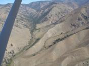
By: 61skyhawk


