Login
Register


MYL
Mc Call Municipal Airport
Official FAA Data Effective 2025-11-27 0901Z
Chart Supplement

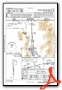
KMYL Airport Diagram

VFR Chart of KMYL
Sectional Charts at SkyVector.com
IFR Chart of KMYL
Enroute Charts at SkyVector.com
Location Information for KMYL
Coordinates: N44°53.32' / W116°6.11'Located 00 miles S of Mc Call, Idaho on 197 acres of land. View all Airports in Idaho.
Surveyed Elevation is 5024 feet MSL.
Operations Data
|
|
Airport Communications
| ASOS: | 119.925 Tel. 208-634-5947 |
|---|---|
| CTAF: | 122.800 |
| UNICOM: | 122.800 |
| AWOS-3P at JSY (56.3 NW): | 123.775 541 432 0458 |
| ASOS at ONO (65.1 SW): | 135.275 541-889-7388 |
| ASOS at BKE (72.7 W): | 134.275 541-523-5412 |
- APCH/DEP CTL SVC PRVDD BY SALT LAKE ARTCC (ZLC) ON FREQ 128.05/306.95 (SQUAW BUTTE RCAG).
Nearby Navigation Aids
|
| ||||||||||||||||||||||||||||||


Runway 16/34
RECOMMEND LNDG RWY 34 AND TKOF RWY 16 WHEN WIND CONDS PERMIT. | ||
| Dimensions: | 6101 x 75 feet / 1860 x 23 meters | |
|---|---|---|
| Surface: | Asphalt in Good Condition | |
| Weight Limits: | S-86, D-141, ST-261 | |
| Edge Lighting: | Medium Intensity | |
| Runway 16 | Runway 34 | |
| Coordinates: | N44°53.83' / W116°6.12' | N44°52.82' / W116°6.09' |
| Elevation: | 5024.1 | 5006.6 |
| Traffic Pattern: | Left | Left |
| Runway Heading: | 179° True | 359° True |
| Markings: | Non-Precision Instrument in fair condition. | Non-Precision Instrument in fair condition. |
| Glide Slope Indicator | V2L (3.50° Glide Path Angle) | |
| REIL: | Yes | Yes |
| Obstacles: | 16 ft Road 650 ft from runway | 80 ft Ground 1500 ft from runway |
Services Available
| Fuel: | 100LL (blue), Jet-A, Jet A-1+ |
|---|---|
| Transient Storage: | Hangars,Tiedowns |
| Airframe Repair: | MAJOR |
| Engine Repair: | MAJOR |
| Bottled Oxygen: | NONE |
| Bulk Oxygen: | NONE |
| Other Services: | AIR AMBULANCE SERVICES,CHARTER SERVICE,PILOT INSTRUCTION,AIRCRAFT RENTAL,AIRCRAFT SALES |
Ownership Information
| Ownership: | Publicly owned | |
|---|---|---|
| Owner: | CITY OF MCCALL | |
| 216 E PARK | ||
| MC CALL, ID 83638 | ||
| 208-634-7142 | ||
| Manager: | EMILY HART | |
| 216 E PARK | ||
| MC CALL, ID 83638 | ||
| 208-634-1488 | ||
Other Remarks
- AUX PWR UNITS MAY NOT BE STARTED UNTIL 30 MINS PRIOR TO ENGINE START. FEES WILL BE CHRGD FOR APU USAGE OVER 30 MIN.
- COLD TEMPERATURE AIRPORT. ALTITUDE CORRECTION REQUIRED AT OR BELOW -19C.
- AIRPORT SURFACE CONDITIONS REPORTED M-F 0800-1700 LCL
- 2 HR PRIOR NOTICE REQUIRED FOR SNOW REMOVAL AT NIGHT CALL 208-634-1488/630-3441
- FOR CD CTC SALT LAKE ARTCC AT 801-320-2568.
- LNDG AND PRKG FEES COLLD BY THIRD PARTY PROVIDER. SEE MCCALLAIRPORT.COM FOR ADNL DTLS.
- SELF-SERVE 100LL ONLY.
- USFS PRACTICES PARACHUTE JUMPS INVOF ARPT.
- BIG GAME ANIMALS MAY BE ON OR IN VICINITY OF RY.
- NO HELICOPTER PARKING IN FIXED WING TIE-DOWN AREAS.
- RY 16 HAS A MARKED 50 FT BLAST PAD.
- INCREASED FOREST SERVICE FLIGHT OPNS DURG SUMMER MONTHS.
- PARALLEL TWY CLSD DEC 1-APR 30.
- ACTIVATE REIL RWY 16 & 34; MIRL RWY 16/34 - CTAF.
Weather Minimums

Instrument Approach Procedure (IAP) Charts

Departure Procedure Obstacles (DPO) Charts

Nearby Airports with Instrument Procedures
| ID | Name | Heading / Distance | ||
|---|---|---|---|---|
 |
S87 | Weiser Municipal Airport | 222° | 55.2 |
|
KJSY | Joseph State Airport | 300° | 56.5 |
|
KGIC | Idaho County Airport | 359° | 63.3 |
|
KONO | Ontario Municipal Airport | 217° | 65.2 |
|
KBKE | Baker City Municipal Airport | 268° | 72.9 |
|
KEUL | Caldwell Exec Airport | 197° | 78.3 |
|
KBOI | Boise Air Trml/Gowen Field Airport | 183° | 79.6 |
|
KMAN | Nampa Municipal Airport | 193° | 80.5 |
|
KLGD | La Grande/Union County Airport | 287° | 84.4 |
|
KSMN | Lemhi County Airport | 080° | 95.6 |
|
KLWS | Lewiston/Nez Perce County Airport | 336° | 97.1 |
|
U76 | Mountain Home Municipal Airport | 171° | 106.6 |
Airport Images

By: mccallaviation@...


