Login
Register


SMN
Lemhi County Airport
Official FAA Data Effective 2026-01-22 0901Z
Chart Supplement

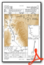
VFR Chart of KSMN
Sectional Charts at SkyVector.com
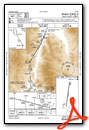
IFR Chart of KSMN
Enroute Charts at SkyVector.com
Location Information for KSMN
Coordinates: N45°7.40' / W113°52.89'Located 04 miles S of Salmon, Idaho on 259 acres of land. View all Airports in Idaho.
Surveyed Elevation is 4044 feet MSL.
Operations Data
|
|
Airport Communications
| AWOS-3PT: | 135.075 Tel. 208-756-4381 |
|---|---|
| UNICOM: | 122.800 |
| CTAF: | 122.800 |
| ASOS at LLJ (38.8 S): | 119.275 208-844-2785 |
| ASOS at DLN (56.7 E): | 135.225 406-683-5470 |
| AWOS-3PT at RVF (71.4 E): | 119.025 406-684-5285 |
- APCH/DEP CTL SVC PRVDD BY SALT LAKE ARTCC (ZLC) ON FREQS 132.4/338.3 (SALMON RCAG).
- COMMUNICATIONS PRVDD BY BOISE RADIO ON FREQ 122.6 (SALMON RCO).
Nearby Navigation Aids
|
| ||||||||||||||||||||||||||||||||||||

Runway 17/35
| Dimensions: | 5510 x 75 feet / 1679 x 23 meters | |
|---|---|---|
| Surface: | Asphalt in Excellent Condition | |
| Weight Limits: | S-12 | |
| Edge Lighting: | Medium Intensity | |
| Runway 17 | Runway 35 | |
| Coordinates: | N45°7.85' / W113°52.80' | N45°6.95' / W113°52.97' |
| Elevation: | 4035.9 | 4044.2 |
| Traffic Pattern: | USE RGT TFC PATTERN FOR NIGHT OPNS ONLY. |
Left |
| Runway Heading: | 188° True | 8° True |
| Markings: | None in good condition. | None in good condition. |
| Glide Slope Indicator | P4L (3.50° Glide Path Angle) | |
| REIL: | Yes | Yes |
Services Available
| Fuel: | 100 (green), Jet-A |
|---|---|
| Transient Storage: | Tiedowns |
| Airframe Repair: | MAJOR |
| Engine Repair: | MAJOR |
| Bottled Oxygen: | NONE |
| Bulk Oxygen: | NONE |
| Other Services: | CHARTER SERVICE,PILOT INSTRUCTION,AIRCRAFT RENTAL |
Ownership Information
| Ownership: | Publicly owned | |
|---|---|---|
| Owner: | LEMHI CO | |
| 206 COURTHOUSE DRIVE | ||
| SALMON, ID 83467 | ||
| 208-756-2815 | ||
| Manager: | CHARLES LAMOURE | |
| 206 COURTHOUSE DRIVE | ||
| SALMON, ID 83467 | ||
| 208-940-2171 | ||
Other Remarks
- RETROREFLECTIVE REFLECTORS ON PARALLEL TWY AND RAMP AREA.
- TAXIWAY ACCESS TO AIRCRAFT RAMP LOCATED ON SE END OF AIRPORT IS CLSD.
- COLD TEMPERATURE AIRPORT. ALTITUDE CORRECTION REQUIRED AT OR BELOW -12C.
- ACTVT MIRL RY 17/35; REIL RY 17 & RY 35 AND PAPI RY 17 - CTAF.
Weather Minimums

Instrument Approach Procedure (IAP) Charts

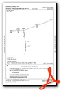
Departure Procedure (DP) Charts

Nearby Airports with Instrument Procedures
| ID | Name | Heading / Distance | ||
|---|---|---|---|---|
 |
KLLJ | Challis Airport | 201° | 38.7 |
|
KDLN | Dillon Airport | 081° | 56.9 |
|
KHRF | Ravalli County Airport | 351° | 68.8 |
|
KRVF | Ruby Valley Field Airport | 069° | 71.3 |
|
3U3 | Bowman Field Airport | 034° | 75.1 |
|
KBTM | Bert Mooney Airport | 048° | 76.8 |
|
32S | Stevensville Airport | 355° | 84.4 |
|
38S | Deer Lodge-City-County Airport | 031° | 89.2 |
|
KAOC | Arco-Butte County Airport | 165° | 94.2 |
|
KEKS | Ennis Big Sky Airport | 083° | 95.2 |
|
KMYL | Mc Call Municipal Airport | 262° | 95.6 |
|
KSUN | Friedman Memorial Airport | 190° | 98.8 |
Airport Images
Do you have a recent image of this airport? Upload it here!


