Login
Register


IAD
Washington Dulles International Airport
Official FAA Data Effective 2025-12-25 0901Z
Chart Supplement

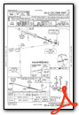
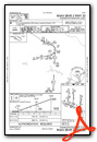
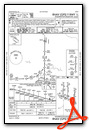
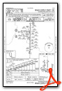
KIAD Airport Diagram

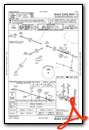
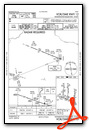
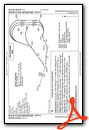
VFR Chart of KIAD
Sectional Charts at SkyVector.com
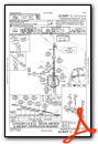
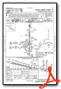
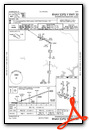
IFR Chart of KIAD
Enroute Charts at SkyVector.com
Location Information for KIAD
Coordinates: N38°56.85' / W77°27.60'Located 20 miles W of Washington, Dist. of Columbia on 13000 acres of land. View all Airports in Dist. of Columbia.
Surveyed Elevation is 312 feet MSL.
Operations Data
|
|
Airport Communications
| D-ATIS: | 134.85 (571-323-6374) |
|---|---|
| ASOS: | 134.85 Tel. 571-250-7817 |
| DULLES TOWER: | 120.1 ;RWY 01R/19L 120.25 ;RWY 01C/19C 134.425 ;RWY 01L/19R, RWY 12/30 317.8 ;RWY 01R/19L 348.6 ;RWY 01C/19C 348.6 ;RWY 01L/19R, RWY 12/30 |
| DULLES GROUND: | 121.625 ;WEST 121.9 ;EAST 317.8 ;EAST 348.6 ;WEST |
| POTOMAC APPROACH: | 120.45 ;241-330 126.1 ;331-090 128.525 ;091-240 306.925 ;091-330 338.25 ;331-090 |
| POTOMAC DEPARTURE: | 125.05 ;300-010 126.65 ;190-300 350.2 |
| CLEARANCE DELIVERY: | 135.7 317.8 |
| MCRAY DP: | 125.05 350.2 |
| CLTCH DP: | 126.65 350.2 |
| RNLDI DP: | 126.65 350.2 |
| DELRO STAR: | 133.0 288.35 |
| CLASS B: | 120.45 ;241-330 126.1 ;331-090 128.525 ;091-240 306.925 ;091-330 338.25 ;331-090 |
| WOOLY DP: | 125.05 350.2 |
| GIBBZ STAR: | 120.45 306.925 |
| SCRAM DP: | 126.65 350.2 |
| JDUBB DP: | 126.65 350.2 |
| PRIVO STAR: | 133.0 288.35 |
| BUNZZ DP: | 126.65 |
| CAPITAL DP: | 125.05 ;POTOMAC DEP CON NORTH 126.65 ;POTOMAC DEP CON SOUTH 350.2 |
| HYPER STAR: | 133.0 288.35 |
| WIGOL STAR: | 132.85 323.125 |
| COATT STAR: | 128.525 306.925 |
| RAMP CTL: | 129.55 ;MIDFLD |
| CAVLR STAR: | 128.525 306.925 |
| SELINSGROVE STAR: | 133.0 288.35 |
| UNICOM: | 122.950 |
| EMERG: | 121.5 243.0 |
| JERES DP: | 125.05 350.2 |
| JCOBY DP: | 125.05 350.2 |
| AWOS-3 at JYO (9.1 NW): | 125.225 703-777-3781 |
| AWOS-3PT at HEF (13.7 S): | 703-361-6160 |
| ATIS at HEF (13.8 S): | 125.175 |
- ASR RADAR UNAVBL ABV 15000 FT.
- ASDE-X IN USE. OPERATE TRANSPONDERS WITH ALTITUDE REPORTING MODE AND ADS-B (IF EQUIPPED) ENABLED ON ALL AIRPORT SURFACES.
- ARRIVALS MAY BE EXTENDED OUTSIDE OF CLASS B.
Nearby Navigation Aids
|
| ||||||||||||||||||||||||||||||||||||||||||||||||||||||||||||


Runway 01C/19C
| Dimensions: | 11500 x 150 feet / 3505 x 46 meters | |
|---|---|---|
| Surface: | Concrete / Grooved in Excellent Condition | |
| Weight Limits: | S-200, D-250, ST-450, DT-875
PCR VALUE: 1089/R/B/W/T
| |
| Edge Lighting: | High Intensity | |
| Runway 01C | Runway 19C | |
| Coordinates: | N38°56.34' / W77°27.59' | N38°58.24' / W77°27.56' |
| Elevation: | 286.1 | 268.6 |
| Traffic Pattern: | Left | Left |
| Runway Heading: | 1° True | 181° True |
| Declared Distances: | TORA:11500 TODA:11500 ASDA:11500 LDA:11500 | TORA:11500 TODA:11500 ASDA:11500 LDA:11089 |
| Markings: | Precision Instrument in good condition. | Precision Instrument in good condition. |
| Glide Slope Indicator | P4L (3.00° Glide Path Angle) | P4R (3.00° Glide Path Angle) |
| RVR Equipment | Touchdown Midfield Rollout | Touchdown Midfield Rollout |
| Approach Lights: | MALSR 1,400 Foot Medium-intensity Approach Lighting System with runway alignment indicator lights. | ALSF2 Standard 2,400 Foot High-intensity Approach Lighting System with sequenced flashers, CATEGORY II or III Configuration. |
| Centerline Lights: | Yes | Yes |
Runway 01R/19L
| Dimensions: | 11500 x 150 feet / 3505 x 46 meters | |
|---|---|---|
| Surface: | Concrete / Grooved in Good Condition | |
| Weight Limits: | S-200, D-250, ST-450, DT-875
PCR VALUE: 1005/R/B/W/U
| |
| Edge Lighting: | High Intensity | |
| Runway 01R | Runway 19L | |
| Coordinates: | N38°55.43' / W77°26.19' | N38°57.32' / W77°26.16' |
| Elevation: | 311.7 | 293.0 |
| Traffic Pattern: | Left | Left |
| Runway Heading: | 1° True | 181° True |
| Declared Distances: | TORA:11500 TODA:11500 ASDA:11500 LDA:11500 | TORA:11500 TODA:11500 ASDA:11500 LDA:11500 |
| Markings: | Precision Instrument in good condition. | Precision Instrument in good condition. |
| Glide Slope Indicator | P4R (3.00° Glide Path Angle) | P4L (3.00° Glide Path Angle) |
| RVR Equipment | Touchdown Midfield Rollout | Touchdown Midfield Rollout |
| Approach Lights: | ALSF2 Standard 2,400 Foot High-intensity Approach Lighting System with sequenced flashers, CATEGORY II or III Configuration. | ALSF2 Standard 2,400 Foot High-intensity Approach Lighting System with sequenced flashers, CATEGORY II or III Configuration. |
| Centerline Lights: | Yes | Yes |
| Obstacles: | 38 ft Pole 1900 ft from runway, 720 ft right of center | |
Runway 12/30
| Dimensions: | 10501 x 150 feet / 3201 x 46 meters | |
|---|---|---|
| Surface: | Concrete / Grooved in Good Condition | |
| Weight Limits: | S-200, D-250, ST-450, DT-875
PCR VALUE: 1108/R/B/W/T
| |
| Edge Lighting: | High Intensity | |
| Runway 12 | Runway 30 | |
| Coordinates: | N38°56.63' / W77°29.43' | N38°56.02' / W77°27.35' |
| Elevation: | 309.9 | 287.6 |
| Traffic Pattern: | Left | Left |
| Runway Heading: | 111° True | 291° True |
| Declared Distances: | TORA:10501 TODA:10501 ASDA:10501 LDA:10501 | TORA:10501 TODA:10501 ASDA:10501 LDA:10501 |
| Markings: | Precision Instrument in good condition. | Precision Instrument in good condition. |
| Glide Slope Indicator | P4R (3.00° Glide Path Angle) | P4L (3.00° Glide Path Angle) |
| RVR Equipment | Touchdown Rollout | Touchdown Rollout |
| Approach Lights: | MALSR 1,400 Foot Medium-intensity Approach Lighting System with runway alignment indicator lights. | |
| REIL: | Yes | |
| Centerline Lights: | Yes | Yes |
Runway 01L/19R
| Dimensions: | 9400 x 150 feet / 2865 x 46 meters | |
|---|---|---|
| Surface: | Concrete / Grooved in Excellent Condition | |
| Weight Limits: | S-200, D-250, ST-450, DT-875
PCR VALUE: 1045/R/B/W/T
| |
| Edge Lighting: | High Intensity | |
| Runway 01L | Runway 19R | |
| Coordinates: | N38°56.70' / W77°28.49' | N38°58.25' / W77°28.47' |
| Elevation: | 296.0 | 277.0 |
| Runway Heading: | 1° True | 181° True |
| Declared Distances: | TORA:9400 TODA:9400 ASDA:9400 LDA:9400 | TORA:9400 TODA:9400 ASDA:9400 LDA:9400 |
| Markings: | Precision Instrument in good condition. | Precision Instrument in good condition. |
| Glide Slope Indicator | P4L (3.00° Glide Path Angle) | P4L (3.00° Glide Path Angle) |
| RVR Equipment | Touchdown Midfield Rollout | Touchdown Midfield Rollout |
| Approach Lights: | ALSF2 Standard 2,400 Foot High-intensity Approach Lighting System with sequenced flashers, CATEGORY II or III Configuration. | ALSF2 Standard 2,400 Foot High-intensity Approach Lighting System with sequenced flashers, CATEGORY II or III Configuration. |
| Centerline Lights: | Yes | Yes |
Services Available
| Fuel: | 100LL (blue), Jet-A |
|---|---|
| Transient Storage: | Hangars,Tiedowns |
| Airframe Repair: | MAJOR |
| Engine Repair: | MAJOR |
| Bottled Oxygen: | HIGH |
| Bulk Oxygen: | HIGH |
| Other Services: | AIR FREIGHT SERVICES,AVIONICS,CARGO HANDLING SERVICES,AIRCRAFT SALES |
Ownership Information
| Ownership: | Publicly owned | |
|---|---|---|
| Owner: | METRO WASH ARPT AUTHORITY | |
| 1 AVIATION CIRCLE | ||
| WASHINGTON, DC 20001-6000 | ||
| 703-417-8600 | ||
| Manager: | RICHARD GOLINOWSKI | |
| 1 SAARINEN CIRCLE, SAARINEN CENTER MA-210 | ||
| DULLES, VA 20166 | ||
| 703-572-2730 | ||
Other Remarks
- TAXILANE 'C' ACTIVE; PUSHBACK CLNCS ON NORTH SIDE OF MIDFIELD TERMINAL ARE ONTO TAXILANE 'D' ONLY UNLESS OTHERWISE AUTH.
- ITNRNT ACFT CTC FBO ON 122.95 OR 129.77 FOR SVCS.
- ALL AIRCRAFT WITH WINGSPAN EXCEEDING 118 FT ARE RESTRICTED FROM USING TAXILANE A BTN A1 & A5.
- RUNUP BLX FOR RWY 30 DSGND AS NON-MOVEMENT AREA.
- ALL 180 DEG TURNS OUT OF APRON POSITIONS SHALL BE MADE USING MINIMUM POWER.
- LDG FEE. FLIGHT NOTIFICATION SERVICE (ADCUS) AVBL. NOTE: SEE SPECIAL NOTICES --CONTINUOUS POWER FACILITIES.
- TWY E1 RESTRICTED TO ACFT WITH A WINGSPAN LESS THAN 79 FT.
- B747-8 RESTRICTED TO MAXIMUM TAXI SPEED 17 KTS (20 MPH) ON TWY J.
- ENGINE RUN-UPS BTW 2200L & 0700L REQUIRE PRIOR APPROVAL FM ARPT OPS.
- RWY 30 DEPARTURES USE UPPER ANTENNA FOR ATC COMMUNICATIONS.
- RWY STATUS LGTS ARE IN OPN.
- PILOTS CONDUCTING EFVS OPS; BE AWARE LED ALS IN USE RWY 01C.
- COCKPIT OVER CNTRLN TAXI PROHIBITED AT TWY Y INT WITH TWY Y11. JUDGMENTAL OVERSTEER RQRED.
- ACR PUSH BACKS & PWR FM ALL APRON PSNS REQUIRE CLNC FM MWAA RAMP TWR.
- LARGE FLOCKS OF BIRDS ON & INVOF ARPT/DEER INVOF ARPT.
- DURING PERIODS OF ACFT SATURATION LONG TERM PARKING MAY NOT BE AVAILABLE. SERVICES FOR FUEL AND GO ONLY WILL BE AVAILABLE.
- FLIGHT TRAINING BETWEEN 2200-0700 IS PROHIBITED.
- LOCATED IN BOTH FAIRFAX COUNTY VA AND LOUDOUN COUNTY VA.
Weather Minimums

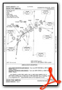
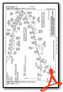
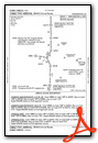
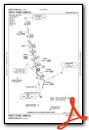
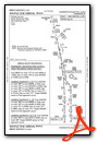
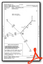
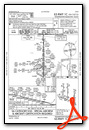
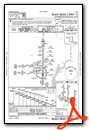
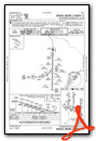
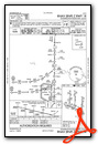
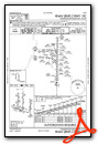
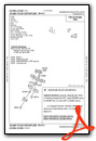
Standard Terminal Arrival (STAR) Charts
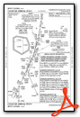

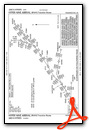
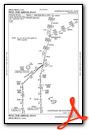

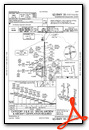
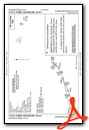
Instrument Approach Procedure (IAP) Charts
- ILS OR LOC RWY 01C
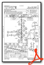
- ILS OR LOC RWY 01L

- ILS OR LOC RWY 01R
- ILS OR LOC RWY 19C

- ILS OR LOC RWY 19L

- ILS OR LOC RWY 19R

- ILS OR LOC/DME RWY 12
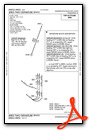
- ILS RWY 01L (CAT II - III)
- ILS RWY 01R (CAT II - III)
- ILS RWY 19C (CAT II - III)
- ILS RWY 19R (CAT II - III)

- ILS RWY 01C (SA CAT II)
- ILS RWY 19L (SA CAT II)
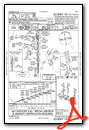
- RNAV (RNP) Z RWY 01C
- RNAV (RNP) Z RWY 01L
- RNAV (RNP) Z RWY 01R
- RNAV (RNP) Z RWY 19C
- RNAV (RNP) Z RWY 19L
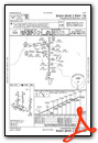
- RNAV (RNP) Z RWY 19R
- RNAV (RNP) Z RWY 30
- RNAV (GPS) RWY 12
- RNAV (GPS) Y RWY 01C
- RNAV (GPS) Y RWY 01L
- RNAV (GPS) Y RWY 01R

- RNAV (GPS) Y RWY 19C
- RNAV (GPS) Y RWY 19L

- RNAV (GPS) Y RWY 19R

- RNAV (GPS) Y RWY 30
- VOR/DME RWY 12
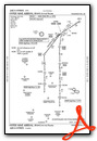
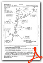
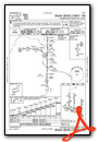
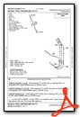
Departure Procedure (DP) Charts


Nearby Airports with Instrument Procedures
| ID | Name | Heading / Distance | ||
|---|---|---|---|---|
 |
KJYO | Leesburg Exec Airport | 329° | 9.1 |
|
KHEF | Manassas Regional/Harry P Davis Field Airport | 190° | 13.8 |
|
KGAI | Montgomery County Airpark Airport | 045° | 19.1 |
|
KDAA | Davison AAF Airport | 136° | 19.1 |
|
KDCA | Ronald Reagan Washington Ntl Airport | 106° | 20.6 |
|
W50 | Davis Airport | 039° | 22.9 |
|
KHWY | Warrenton/Fauquier Airport | 208° | 24.6 |
|
KCGS | College Park Airport | 085° | 25.2 |
|
KVKX | Potomac Airfield Airport | 116° | 26.5 |
|
KNYG | Quantico Mcaf (Turner Field) Airport | 164° | 27.6 |
|
2W5 | Maryland Airport | 138° | 27.8 |
|
KFDK | Frederick Municipal Airport | 008° | 28.4 |


