Login
Register


W50
Davis Airport
Official FAA Data Effective 2026-02-19 0901Z
Chart Supplement

VFR Chart of W50
Sectional Charts at SkyVector.com
IFR Chart of W50
Enroute Charts at SkyVector.com
Location Information for W50
Coordinates: N39°14.59' / W77°9.05'Located 03 miles N of Laytonsville, Maryland on 20 acres of land. View all Airports in Maryland.
Surveyed Elevation is 609 feet MSL.
Operations Data
|
|
Airport Communications
| CTAF: | 122.800 |
|---|---|
| UNICOM: | 122.800 |
| TRSTN STAR: | 126.75 307.2 |
| AWOS-3PT at GAI (4.6 S): | 128.275 301-977-2971 |
| AWOS-3 at FDK (14.6 NW): | 301-600-1457 |
| ATIS at FDK (14.7 NW): | 124.875 |
Nearby Navigation Aids
|
| ||||||||||||||||||||||||||||||||||||||||||||||||||||||||||||


Runway 08/26
| Dimensions: | 2600 x 50 feet / 792 x 15 meters | |
|---|---|---|
| Surface: | Asphalt in Good Condition | |
| Runway 08 | Runway 26 | |
| Coordinates: | N39°14.51' / W77°9.30' | N39°14.68' / W77°8.80' |
| Elevation: | 589.0 | 609.0 |
| Traffic Pattern: | Left | Left |
| Runway Heading: | 66° True | 246° True |
| Markings: | Basic in good condition. | Basic in good condition. |
| Obstacles: | 57 ft Trees 712 ft from runway, 100 ft left of center | 51 ft Trees 836 ft from runway, 177 ft left of center |
Services Available
| Fuel: | 100LL (blue) |
|---|---|
| Transient Storage: | Tiedowns |
| Airframe Repair: | MINOR |
| Engine Repair: | MINOR |
| Bottled Oxygen: | NONE |
| Bulk Oxygen: | NONE |
| Other Services: | PILOT INSTRUCTION,AIRCRAFT RENTAL |
Ownership Information
| Ownership: | Privately Owned | |
|---|---|---|
| Owner: | LAYTONSVILLE AIRPORT, LLC. | |
| 7200 HAWKINS CREAMERY RD | ||
| GAITHERSBURG, MD 20882 | ||
| 301-253-2897 | ||
| Manager: | ALICIA HARVEY STANLEY | |
| 7200 HAWKINS CREAMERY RD | ||
| LAYTONSVILLE, MD 20882 | ||
| 301-253-2897 | ||
Other Remarks
- ARPT CLSD DUSK-DAWN.
- BIRDS & WILDLIFE ON & INVOF ARPT.
- TOUCH & GO OPS NA.
- FOR CD CTC POTOMAC APCH AT 866-429-5882.
- POND 80 FT R OF THR.
- UNICOM UNMON.
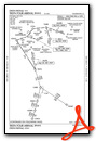
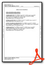
Standard Terminal Arrival (STAR) Charts
Nearby Airports with Instrument Procedures
| ID | Name | Heading / Distance | ||
|---|---|---|---|---|
 |
KGAI | Montgomery County Airpark Airport | 188° | 4.5 |
|
KFDK | Frederick Municipal Airport | 315° | 14.7 |
|
2W2 | Clearview Airpark Airport | 024° | 14.8 |
|
KCGS | College Park Airport | 145° | 19.0 |
|
KFME | Fort Meade Exec Airport | 117° | 20.6 |
|
KJYO | Leesburg Exec Airport | 242° | 21.4 |
|
KBWI | Baltimore/Washington International Thurgood Marshall Airport | 100° | 22.8 |
|
KIAD | Washington Dulles International Airport | 219° | 22.9 |
|
KDMW | Carroll County Regional/Jack B Poage Field Airport | 016° | 22.9 |
|
KDCA | Ronald Reagan Washington Ntl Airport | 167° | 24.1 |
|
W00 | Freeway Airport | 135° | 25.3 |
|
KADW | Joint Base Andrews Airport | 152° | 29.1 |
Airport Images
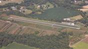
By: wkrozack

By: wkrozack


