Login
Register


ILG
New Castle Airport
Official FAA Data Effective 2026-02-19 0901Z
Chart Supplement

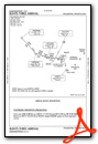
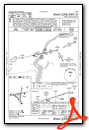
KILG Airport Diagram

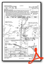
VFR Chart of KILG
Sectional Charts at SkyVector.com
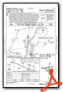
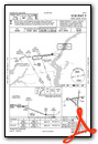
IFR Chart of KILG
Enroute Charts at SkyVector.com
Location Information for KILG
Coordinates: N39°40.72' / W75°36.40'Located 04 miles S of Wilmington, Delaware on 1250 acres of land. View all Airports in Delaware.
Surveyed Elevation is 79 feet MSL.
Operations Data
|
|
Airport Communications
| ATIS: | 123.95 |
|---|---|
| ASOS: | 123.95 Tel. 302-217-3317 |
| WILMINGTON TOWER: | 126.0 352.05 |
| WILMINGTON GROUND: | 121.7 275.8 |
| PHILADELPHIA APPROACH: | 118.35 323.1 |
| PHILADELPHIA DEPARTURE: | 118.35 323.1 |
| CLEARANCE DELIVERY: | 119.95 |
| ARNG OPS: | 46.9FM |
| EMERG: | 121.5 243.0 |
| ARLFT STAR: | 132.425 257.875 |
| UNICOM: | 122.950 |
| CTAF: | 126.000 |
| AWOS-3 at EVY (10.8 SW): | 132.325 302-378-2063 |
| AWOS-3T at OQN (18.7 N): | 121.4 (610) 692-6190 |
| ASOS at PHL (20.5 NE): | 133.4 215-492-9617 |
- CLEARANCE DELIVERY PHILADELPHIA APCH TF 800-354-9884.
Nearby Navigation Aids
|
| ||||||||||||||||||||||||||||||||||||||||||||||||||||||||||||


Runway 09/27
| Dimensions: | 7275 x 150 feet / 2217 x 46 meters | |
|---|---|---|
| Surface: | Asphalt / Grooved in Fair Condition | |
| Weight Limits: | S-120, D-250, ST-524, DT-1034
PCR VALUE: 632/F/B/X/T
| |
| Edge Lighting: | High Intensity | |
| Runway 09 | Runway 27 | |
| Coordinates: | N39°40.68' / W75°37.24' | N39°40.94' / W75°35.72' |
| Elevation: | 79.8 | 71.3 |
| Traffic Pattern: | Left | Left |
| Runway Heading: | 78° True | 258° True |
| Declared Distances: | TORA:7275 TODA:7275 ASDA:7000 LDA:7000 | TORA:7275 TODA:7275 ASDA:7000 LDA:7000 |
| Markings: | Precision Instrument in good condition. | Non-Precision Instrument in good condition. |
| Glide Slope Indicator | P4L (3.00° Glide Path Angle) | P4L (3.00° Glide Path Angle) |
| REIL: | Yes | Yes |
| Obstacles: | 49 ft Trees 1125 ft from runway, 600 ft left of center | 64 ft Trees 1000 ft from runway |
Runway 01/19
| Dimensions: | 7012 x 150 feet / 2137 x 46 meters | |
|---|---|---|
| Surface: | Asphalt / Grooved in Excellent Condition | |
| Weight Limits: | S-120, D-250, ST-550, DT-1056
PCR VALUE: 441/F/B/X/T
| |
| Edge Lighting: | High Intensity | |
| Runway 01 | Runway 19 | |
| Coordinates: | N39°40.16' / W75°36.23' | N39°41.31' / W75°36.10' |
| Elevation: | 74.9 | 61.0 |
| Traffic Pattern: | Left | Left |
| Runway Heading: | 5° True | 185° True |
| Declared Distances: | TORA:7012 TODA:7012 ASDA:7012 LDA:7012 | TORA:7012 TODA:7012 ASDA:7012 LDA:7012 |
| Markings: | Precision Instrument in good condition. | Non-Precision Instrument in good condition. |
| Glide Slope Indicator | P4L (3.00° Glide Path Angle) | |
| RVR Equipment | Touchdown | Rollout |
| Approach Lights: | MALSR 1,400 Foot Medium-intensity Approach Lighting System with runway alignment indicator lights. | |
| REIL: | Yes | |
| Obstacles: | 8 ft Road 500 ft from runway | 72 ft Trees 1240 ft from runway, 500 ft left of center |
Runway 14/32
RWY 14/32 NOT AVBL FOR PART 121/PART 380 OPS WITH SKED PAX CARRYING OPS MORE THAN 9 PAX SEATS AND NON-SKED PAX CARRYING OPS MORE THAN 30 PAX SEATS. NO PART 121/PART 380 OPS EXC FOR TAX. | ||
| Dimensions: | 4602 x 150 feet / 1403 x 46 meters | |
|---|---|---|
| Surface: | Asphalt in Fair Condition | |
| Weight Limits: | S-111, D-181, ST-328, DT-763
PCR VALUE: 400/F/B/X/T
| |
| Edge Lighting: | Medium Intensity RWY 14/32 NON-STANDARD MILITARY ASSAULT LANDING ZONE (ALZ) LIGHTING. | |
| Runway 14 | Runway 32 | |
| Coordinates: | N39°40.81' / W75°37.00' | N39°40.32' / W75°36.26' |
| Elevation: | 75.2 | 74.2 |
| Traffic Pattern: | Left | Left |
| Runway Heading: | 131° True | 311° True |
| Declared Distances: | TORA:4602 TODA:4602 ASDA:4602 LDA:4602 | TORA:4602 TODA:4602 ASDA:4602 LDA:4602 |
| Markings: | Basic in good condition. | Basic in good condition. |
| Glide Slope Indicator | V4L (3.00° Glide Path Angle) | |
| Obstacles: | 43 ft Trees 720 ft from runway, 200 ft left of center | |
Services Available
| Fuel: | 100LL (blue), Jet-A |
|---|---|
| Transient Storage: | Hangars,Tiedowns |
| Airframe Repair: | MAJOR |
| Engine Repair: | MAJOR |
| Bottled Oxygen: | HIGH/LOW |
| Bulk Oxygen: | HIGH/LOW |
| Other Services: | AIR AMBULANCE SERVICES,AVIONICS,CARGO HANDLING SERVICES,PILOT INSTRUCTION,AIRCRAFT RENTAL,AIRCRAFT SALES |
Ownership Information
| Ownership: | Publicly owned | |
|---|---|---|
| Owner: | DELAWARE RIVER & BAY AUTHORITY | LEASEE. PROPERTY OWNED BY NEW CASTLE COUNTY 87 READS WAY NEW CASTLE, DE 19720. TEL 302-395-5990. |
| 151 N. DUPONT HIGHWAY | ||
| NEW CASTLE, DE 19720-0071 | ||
| (302) 571-6445 | ||
| Manager: | BENJAMIN CLENDANIEL | |
| 151 N. DUPONT HIGHWAY | ||
| NEW CASTLE, DE 19720-0071 | ||
| (302) 229-6315 | ||
Other Remarks
- WHEN ATCT CLSD, PILOTS MUST ANNOUNCE INTENTIONS OVER CTAF BEFORE LDGS; TKOFS OR GND TRAVEL ON RYS & TWYS.
- PVT GND VEHICLES CROSS TWY A BTN TWYS A4 & C.
- WHEN ATCT CLSD ANNOUNCE EMERGENCIES ON CTAF DIRECTLY TO ARFF STATION.
- MILITARY: ANG: EXPECT INCR BIRD ACT (INCL WATERFOWL) DUR BASH PHASE II (MAR-MAY & SEP-NOV). CTC CASTLE OPS FOR CURRENT BIRD WATCH COND.
- TERMINAL APRON CLSD EXCEPT AIR CARRIER.
- ARNG - OPR 1200-2130Z++ WKD (OPEN ADDN HR FOR SKED TRNG), CLSD SAT, SUN AND HOL. PPR ONLY DSN 440-7205, C302-326-7205. LTD TRAN MAINT, SVC, PRK. CTC GRIFFIN OPS 46.90 10 MIN OUT.
- BIRDS ON & INVOF ARPT.
- FOR CD WHEN ATCT IS CLSD CTC PHL APCH AT (800) 354-9884.
- TRML APRON FENCE LINE 118 FT E OF TWY A CNTRLN.
- RWY 01 5000 FT DIST RMNG SIGN MISG.
- RWY 27 5000 FT DIST RMNG SIGN MISG.
- RWY 09 2000 FT DIST RMNG SIGN MISG.
- RWY 09/27 NO TGL FOR TURBO JET 2300-0700.
- TAXILANE 'G' NORTHWEST OF TWY 'H' LTD TO ACFT WITH WINGSPAN OF 79 FT OR LESS. TAXILANE 'G' SECTION BTW TWY 'H' & TWY 'G1' LTD TO ACFT WITH WINGSPAN OF 49 FT OR LESS.
- WHEN TWR CLSD ACTVT MALSR RWY 01; REIL RWY 09, 27 & 19; PAPI RWY 09 & 27; HIRL RWY 01/19 & 09/27; MIRL RWY 14/32 - CTAF.
- ENGINEERED MATERIAL ARRESTING SYSTEM (EMAS) 303 FT IN LENGTH BY 170 FT IN WIDTH LCTD AT DER 19.
Weather Minimums

Standard Terminal Arrival (STAR) Charts


Instrument Approach Procedure (IAP) Charts


Nearby Airports with Instrument Procedures
| ID | Name | Heading / Distance | ||
|---|---|---|---|---|
 |
KEVY | Summit Airport | 209° | 10.9 |
|
N57 | New Garden Airport | 320° | 11.8 |
|
58M | Claremont Airport | 242° | 13.7 |
|
KOQN | Brandywine Regional Airport | 003° | 18.7 |
|
KPHL | Philadelphia International Airport | 055° | 20.5 |
|
KMQS | Chester County G O Carlson Airport | 326° | 21.6 |
|
17N | Cross Keys Airport | 086° | 26.6 |
|
33N | Delaware Airpark Airport | 179° | 27.6 |
|
0W3 | Harford County Airport | 256° | 28.4 |
|
KMIV | Millville Municipal Airport | 126° | 31.0 |
|
19N | Pine Valley Airport | 078° | 31.1 |
|
KLOM | Wings Field Airport | 029° | 31.7 |
Fuel Providers

Airport Images
Do you have a recent image of this airport? Upload it here!


