Login
Register


PHL
Philadelphia International Airport
Official FAA Data Effective 2026-02-19 0901Z
From the Flight Deck
Chart Supplement

KPHL Airport Diagram

VFR Chart of KPHL
Sectional Charts at SkyVector.com
IFR Chart of KPHL
Enroute Charts at SkyVector.com
Location Information for KPHL
Coordinates: N39°52.33' / W75°14.44'Located 05 miles SW of Philadelphia, Pennsylvania on 2302 acres of land. View all Airports in Pennsylvania.
Surveyed Elevation is 35 feet MSL.
Operations Data
|
|
Airport Communications
| D-ATIS: | 133.4 ;ARR 135.925 ;DEP |
|---|---|
| ASOS: | 133.4 Tel. 215-492-9617 |
| PHILADELPHIA TOWER: | 118.5 ;RWY 08/26, 09L/27R, 17/35 135.1 ;RWY 09R/27L 327.05 |
| PHILADELPHIA GROUND: | 121.65 121.9 348.6 |
| PHILADELPHIA APPROACH: | 123.8 ;001-089, 5000 FT & BLW 124.35 125.4 126.85 ;270-360, 5000 FT & BLW 127.35 ;090-269, 5000 FT & BLW 128.4 ;270-089, ABV 5000 FT 133.875 ;090-269, 6000-8000 FT 263.125 ;270-360, 5000 FT & BLW 272.575 ;270-089, ABV 5000 FT 273.575 ;270-089, ABV 5000 FT 291.7 ;001-089, 5000 FT & BLW 317.55 ;090-269 6000-8000 FT 317.55 ;090-269, 5000 FT & BLW 319.15 |
| PHILADELPHIA DEPARTURE: | 119.75 ;090-269 124.35 ;270-089 124.35 269.25 ;090-269 319.15 ;270-089 319.15 |
| IC: | 124.35 319.15 |
| CLEARANCE DELIVERY: | 118.85 348.6 |
| FINAL: | 125.4 |
| PAATS STAR: | 133.875 317.55 |
| PRM: | 120.425 ;RWY 27L 123.6 ;RWY 26 |
| UNICOM: | 122.950 |
| CLASS B: | 118.35 ;SW 6000 FT & BLW 119.75 ;SE RWY 09 ACTIVE 10000 FT & BLW 119.75 ;SE RWY 27 ACTIVE 8500-10000 FT 119.75 ;SOUTH/SOUTHWEST RWY 27 8500-10000 FT 123.8 ;NE 6500 FT & BLW 124.35 ;NE 7000-10000 FT 124.35 ;NW 8000-10000 FT 124.35 ;W RWY 09 ACTIVE 8500-10000 FT 124.35 ;W RWY 27 ACTIVE 10000 FT & BLW 126.85 ;5500 FT & BLW 127.35 ;SE-SW 5000 FT & BLW 128.4 ;NORTH 6500-7500 128.4 ;WEST RWY 09 ACTIVE 8000 FT & BLW 133.875 ;6000-8000 FT 133.875 ;SOUTHEAST RWY 27 5500-7500 263.125 ;5500 FT & BLW 269.25 ;SE RWY 09 ACTIVE 10000 FT & BLW 269.25 ;SE RWY 27 ACTIVE 8500-10000 FT 269.25 ;SOUTH/SOUTHWEST RWY 27 8500-10000 FT 272.575 ;NORTH 6500-7500 272.575 ;WEST RWY 09 ACTIVE 8000 FT & BLW 273.575 ;N NE 6500-7500 273.575 ;W RWY 09 ACTIVE 8000 FT & BLW 291.7 ;NE RWY 27 ACTIVE 5000 FT & BLW 317.55 ;6000-8000 FT 317.55 ;RWY 27, 5500-7500 FT 317.55 ;SE-SW 5000 FT & BLW 319.15 ;NE 7000-10000 FT 319.15 ;NW 8000-10000 FT 319.15 ;WEST RWY 09 ACTIVE 8500-10000 FT 323.1 ;SW 6000 FT & BLW |
| SLATT STAR: | 128.4 273.575 |
| JIIMS STAR: | 133.875 317.55 |
| 5500 & BLO: | 123.8 ;NORTH 291.7 ;NORTH |
| SPUDS STAR: | 128.4 272.575 |
| PHILADELPHIA DP: | 119.75 ;SOUTH DEP CON 124.35 ;NORTH DEP CON 269.25 ;SOUTH DEP CON 319.15 ;NORTH DEP CON |
| BUNTS STAR: | 128.4 272.575 |
| EMERG: | 121.5 243.0 |
| AWOS-3 at LOM (16.0 N): | 118.925 215-646-1068 |
| ATIS at PNE (16.5 NE): | 121.15 |
| ASOS at PNE (16.5 NE): | 215-897-9068 |
- ASDE-X IN USE. OPERATE TRANSPONDERS WITH ALTITUDE REPORTING MODE AND ADS-B (IF EQUIPPED) ENABLED ON ALL AIRPORT SURFACES.
- CLASS B: PILOTS CAN EXPC TO EXIT & RE-ENTER THE PHL CLASS B ASP DRG MDT TO HVY ARR PDS.
Nearby Navigation Aids
|
| ||||||||||||||||||||||||||||||||||||||||||||||||||||||||||||


Runway 09R/27L
| Dimensions: | 12000 x 200 feet / 3658 x 61 meters | |
|---|---|---|
| Surface: | Asphalt / Grooved in Good Condition | |
| Weight Limits: | S-120, D-250, ST-550, DT-1048
PCR VALUE: 839/F/C/W/T
| |
| Edge Lighting: | High Intensity | |
| Runway 09R | Runway 27L | |
| Coordinates: | N39°51.65' / W75°16.51' | N39°52.14' / W75°14.03' |
| Elevation: | 20.1 | 10.2 |
| Traffic Pattern: | Left | Left |
| Runway Heading: | 75° True | 255° True |
| Displaced Threshold: | 1913 Feet | |
| Declared Distances: | TORA:12000 TODA:12000 ASDA:12000 LDA:12000 | TORA:12000 TODA:12000 ASDA:11825 LDA:9912 |
| Markings: | Precision Instrument in good condition. | Precision Instrument in good condition. |
| Glide Slope Indicator | P4R (3.00° Glide Path Angle) | P4L (3.00° Glide Path Angle) |
| RVR Equipment | Touchdown Midfield Rollout | Touchdown Midfield Rollout |
| Approach Lights: | ALSF2 Standard 2,400 Foot High-intensity Approach Lighting System with sequenced flashers, CATEGORY II or III Configuration. | MALSR 1,400 Foot Medium-intensity Approach Lighting System with runway alignment indicator lights. |
| Centerline Lights: | Yes | Yes |
| Obstacles: | 45 ft Trees 335 ft from runway, 497 ft left of center | 189 ft Boat 4500 ft from runway, 827 ft left of center |
Runway 09L/27R
| Dimensions: | 9500 x 150 feet / 2896 x 46 meters | |
|---|---|---|
| Surface: | Asphalt / Grooved in Good Condition | |
| Weight Limits: | S-120, D-250, ST-542, DT-1059
PCR VALUE: 702/F/B/W/T
| |
| Edge Lighting: | High Intensity | |
| Runway 09L | Runway 27R | |
| Coordinates: | N39°52.12' / W75°15.34' | N39°52.51' / W75°13.37' |
| Elevation: | 13.2 | 10.4 |
| Traffic Pattern: | Left | Left |
| Runway Heading: | 75° True | 255° True |
| Declared Distances: | TORA:9500 TODA:9500 ASDA:9500 LDA:9500 |
TORA:9500
TODA:9500
ASDA:9500
LDA:8864
RWY 27R LDA 9500 FT AVBL O/R TO ATC.
|
| Markings: | Precision Instrument in good condition. | Precision Instrument in good condition. |
| Glide Slope Indicator | P4L (3.00° Glide Path Angle) | |
| RVR Equipment | Touchdown Midfield Rollout | Touchdown Midfield Rollout |
| Approach Lights: | MALSR 1,400 Foot Medium-intensity Approach Lighting System with runway alignment indicator lights. | MALSR 1,400 Foot Medium-intensity Approach Lighting System with runway alignment indicator lights. |
| REIL: | Yes | |
| Centerline Lights: | Yes | Yes |
| Obstacles: | 91 ft Trees 4090 ft from runway, 429 ft right of center | 189 ft Boat 4500 ft from runway |
Runway 17/35
| Dimensions: | 6500 x 150 feet / 1981 x 46 meters | |
|---|---|---|
| Surface: | Asphalt / Grooved in Good Condition | |
| Weight Limits: | S-120, D-203, ST-302, DT-803
PCR VALUE: 554/F/C/W/T
| |
| Edge Lighting: | High Intensity | |
| Runway 17 | Runway 35 | |
| Coordinates: | N39°53.26' / W75°14.17' | N39°52.26' / W75°13.67' |
| Elevation: | 8.2 | 12.9 |
| Traffic Pattern: | Left | Left |
| Runway Heading: | 159° True | 339° True |
| Declared Distances: | TORA:6500 TODA:6500 ASDA:6500 LDA:6500 | TORA:6500 TODA:6500 ASDA:6500 LDA:6500 |
| Markings: | Precision Instrument in good condition. | Precision Instrument in good condition. |
| Glide Slope Indicator | P4L (3.00° Glide Path Angle) | P4L (3.15° Glide Path Angle) |
| RVR Equipment | Touchdown Rollout | Touchdown Rollout |
| Approach Lights: | MALSF 1,400 Foot Medium-intensity Approach Lighting System with sequenced flashers. | |
| REIL: | Yes | |
| Obstacles: | 50 ft Tree 1279 ft from runway, 516 ft left of center | 189 ft Boat 2150 ft from runway |
Runway 08/26
LND RWY 26 TKOF RWY 08. | ||
| Dimensions: | 5001 x 150 feet / 1524 x 46 meters | |
|---|---|---|
| Surface: | Asphalt / Grooved in Good Condition | |
| Weight Limits: | S-83, D-135, ST-226
PCR VALUE: 317/F/B/X/T
| |
| Edge Lighting: | High Intensity | |
| Runway 08 | Runway 26 | |
| Coordinates: | N39°52.70' / W75°13.80' | N39°52.91' / W75°12.77' |
| Elevation: | 9.3 | 35.9 |
| Runway Heading: | 75° True | 256° True |
| Declared Distances: | TORA:5001 TODA:5001 ASDA:5001 LDA:5001 | TORA:5001 TODA:5001 ASDA:5001 LDA:5001 |
| Markings: | Basic in good condition. | Precision Instrument in good condition. |
| Glide Slope Indicator | P4R (3.15° Glide Path Angle) PAPI UNUSBL BYD 8 DEGS R OF CNTRLN. | |
| RVR Equipment | Touchdown Rollout | Touchdown Rollout |
| Approach Lights: | MALSR 1,400 Foot Medium-intensity Approach Lighting System with runway alignment indicator lights. | |
| Centerline Lights: | Yes | Yes |
| Obstacles: | 24 ft Tree 676 ft from runway, 330 ft left of center | |
Services Available
| Fuel: | 100LL (blue), Jet-A |
|---|---|
| Transient Storage: | Hangars,Tiedowns |
| Airframe Repair: | MAJOR |
| Engine Repair: | MAJOR |
| Bottled Oxygen: | HIGH/LOW |
| Bulk Oxygen: | HIGH/LOW |
| Other Services: | AIR FREIGHT SERVICES,CARGO HANDLING SERVICES,CHARTER SERVICE |
Ownership Information
| Ownership: | Publicly owned | |
|---|---|---|
| Owner: | CITY OF PHILADELPHIA | |
| DEPARTMENT OF AVIATION, 2 INTERNATIONAL PLAZA, SUITE 400 | ||
| PHILADELPHIA, PA 19113 | ||
| 215-937-6800 | ||
| Manager: | ATIF SAEED | |
| DEPARTMENT OF AVIATION, 2 INTERNATIONAL PLAZA, SUITE 400 | ||
| PHILADELPHIA, PA 19113 | ||
| 215-937-6914 | ||
Other Remarks
- BIRDS ON & INVOF ARPT.
- TWY J BTN TWYS K3 & Q RSTRD TO ACFT WITH WINGSPANS 171 FT & LESS.
- ONLY NOSE-IN PRKG PMTD ON N REMOTE APNS. PPR FM ARPT OPS FOR ALL ACFT PRKG ON REMOTE APNS; CTC 215-937-6914/6800.
- POSS UNMARKED SHIP OBSTN TRANSITING E OR W ALG THE DELAWARE RIVER REACHING HGTS OF 189 FT - BE ALERT WHEN APCHG PHL RWY 35 & WHENEVER CIRCLING OR VISUALLY APCHG ALL OTHER RWYS.
- RWYS 27L, 27R & 35 SHIP CHNL (DELAWARE RIVER) MAX HGT OF SHIPS 189 FT. RWY 26 SHIP CHNL (SCHUYLKILL) MAX HGT OF SHIPS 149 FT.
- ARPT IS LCTD IN A NOISE SENSITIVE AREA. AIRPORT NOISE ABATEMENT TKOF PROCS ARE TO BE USED.
- TCAS EQUIPPED ACFT-TCAS ALERT MAY BE CAUSED BY TRANSPONDER EQUIPPED SHIPS LCTD PHL NAVAL BASE 3 NM E.
- UNLGTD STACK 288 FT MSL (271 FT AGL) 2.3 NM SW OF ARPT.
- RWY 09R ROLLOUT RVR USED FOR RWY 09L MIDPOINT RVR.
- ALL ENGINE RUNUPS RQR PPR FM DUTY OPS OFFICER AT 937-6914/6800; RUNUPS 20 MIN MAX.
- ALL ACFT TRAVELING ON TWY J MUST USE MNM PWR WHEN TURNING S DUE TO JETBLAST CONCERNS.
Weather Minimums

Standard Terminal Arrival (STAR) Charts

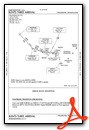

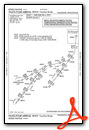
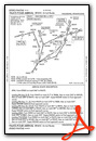


Instrument Approach Procedure (IAP) Charts
- ILS OR LOC RWY 09L

- ILS OR LOC RWY 26

- ILS OR LOC RWY 27L

- ILS OR LOC RWY 27R

- ILS Z OR LOC RWY 17

- ILS Z OR LOC Z RWY 09R

- ILS Z RWY 09R (SA CAT I)

- ILS RWY 27R (SA CAT I - II)

- ILS Z RWY 09R (CAT II - III)

- ILS RWY 09L (SA CAT II)

- ILS RWY 27L (SA CAT II)

- ILS V RWY 09R (CONVERGING)

- ILS V RWY 17 (CONVERGING)

- RNAV (RNP) Z RWY 09L

- RNAV (RNP) Z RWY 09R

- RNAV (GPS) RWY 17

- RNAV (GPS) RWY 26

- RNAV (GPS) RWY 27L

- RNAV (GPS) RWY 27R

- RNAV (GPS) RWY 35

- RNAV (GPS) Y RWY 09L

- RNAV (GPS) Y RWY 09R

- FREEDOM VISUAL RWY 09L

- LIBERTY VISUAL RWY 27L

- RIVER VISUAL RWY 09L/R

Departure Procedure (DP) Charts


Nearby Airports with Instrument Procedures
| ID | Name | Heading / Distance | ||
|---|---|---|---|---|
 |
17N | Cross Keys Airport | 136° | 13.9 |
|
19N | Pine Valley Airport | 112° | 14.7 |
|
KLOM | Wings Field Airport | 355° | 16.0 |
|
KPNE | Northeast Philadelphia Airport | 040° | 16.5 |
|
KOQN | Brandywine Regional Airport | 294° | 17.3 |
|
KVAY | South Jersey Regional Airport | 076° | 18.7 |
|
N14 | Flying W Airport | 079° | 20.4 |
|
KILG | New Castle Airport | 235° | 20.5 |
|
N57 | New Garden Airport | 264° | 24.6 |
|
N81 | Hammonton Municipal Airport | 118° | 25.5 |
|
KPTW | Heritage Field Airport | 326° | 26.4 |
|
KDYL | Doylestown Airport | 011° | 28.2 |
Airport Images
Do you have a recent image of this airport? Upload it here!


