Login
Register


INF
Inverness Airport
Official FAA Data Effective 2026-02-19 0901Z
Chart Supplement

VFR Chart of KINF
Sectional Charts at SkyVector.com
IFR Chart of KINF
Enroute Charts at SkyVector.com
Location Information for KINF
Coordinates: N28°48.22' / W82°19.10'Located 02 miles SE of Inverness, Florida on 347 acres of land. View all Airports in Florida.
Surveyed Elevation is 64 feet MSL.
Operations Data
|
|
Airport Communications
| AWOS-3: | 119.975 Tel. 352-560-6012 |
|---|---|
| JACKSONVILLE APPROACH: | 118.6 251.15 |
| JACKSONVILLE DEPARTURE: | 118.6 251.15 |
| UNICOM: | 122.725 |
| CTAF: | 122.725 |
| AWOS-3 at CGC (14.0 W): | 118.325 352-563-6600 |
| ASOS at BKV (21.1 S): | 134.725 352-799-5881 |
| ATIS at OCF (22.7 N): | 128.125 |
Nearby Navigation Aids
|
| ||||||||||||||||||||||||||||||||||||||||||||||||


Runway 01/19
| Dimensions: | 5000 x 75 feet / 1524 x 23 meters | |
|---|---|---|
| Surface: | Asphalt / Grooved in Good Condition | |
| Weight Limits: | 16 /F/A/X/T, S-53, D-75 | |
| Edge Lighting: | Medium Intensity | |
| Runway 01 | Runway 19 | |
| Coordinates: | N28°47.81' / W82°19.15' | N28°48.63' / W82°19.05' |
| Elevation: | 64.4 | 40.2 |
| Traffic Pattern: | Right | Left |
| Runway Heading: | 6° True | 186° True |
| Markings: | Non-Precision Instrument in good condition. | Non-Precision Instrument in good condition. |
| Glide Slope Indicator | P4L (3.50° Glide Path Angle) | P4L (3.50° Glide Path Angle) |
| REIL: | Yes | Yes |
| Obstacles: | 43 ft Tree 900 ft from runway, 200 ft left of center | 98 ft Trees 1665 ft from runway, 315 ft right of center |
Services Available
| Fuel: | 100LL (blue), Jet A+ |
|---|---|
| Transient Storage: | Tiedowns |
| Airframe Repair: | MAJOR |
| Engine Repair: | MAJOR |
| Bottled Oxygen: | NONE |
| Bulk Oxygen: | NONE |
| Other Services: | AIR AMBULANCE SERVICES,GLIDER SERVICE,PILOT INSTRUCTION,AIRCRAFT RENTAL,AIRCRAFT SALES,GLIDER TOWING SERVICES |
Ownership Information
| Ownership: | Publicly owned | |
|---|---|---|
| Owner: | CITRUS COUNTY | |
| 110 NORTH APOPKA AVE | ||
| INVERNESS, FL 34450 | ||
| 352-527-5478 | ||
| Manager: | TODD REGAN | |
| 4250 SOUTH AIRPORT RD | ||
| INVERNESS, FL 34450 | ||
| 407-734-1442 | ||
Other Remarks
- RWY 19 300' AGL TOWER 5600' N OF THR 2500' R OF CL.
- FOR CD CTC JACKSONVILLE APCH AT 904-741-0284.
- UNLGTD OBSTNS IN RWY 01 APCH, TREES 89 FT TALL, 2140 FT FM AER RWY 01.
- UNLGTD OBSTNS IN RWY 19 APPCH, TREES 98 FT TALL, 1,655 FT FM AER RWY 19.
- 0LL FUEL 24 HR CREDIT CARD SVC AVBL.
- ACTVT REIL RWY 01 & 19; MIRL RWY 01/19 - CTAF.
Weather Minimums

Instrument Approach Procedure (IAP) Charts


Nearby Airports with Instrument Procedures
| ID | Name | Heading / Distance | ||
|---|---|---|---|---|
 |
KCGC | Crystal River/Davis Field Airport | 285° | 14.0 |
|
X35 | Marion County Airport | 348° | 15.8 |
|
KBKV | Brooksville-Tampa Bay Regional Airport | 200° | 21.1 |
|
KOCF | Ocala International-Jim Taylor Field Airport | 012° | 22.6 |
|
KLEE | Leesburg International Airport | 087° | 26.9 |
|
X60 | Williston Regional Airport | 346° | 33.9 |
|
KZPH | Zephyrhills Municipal Airport | 165° | 35.6 |
|
X23 | Umatilla Municipal Airport | 078° | 35.9 |
|
X04 | Orlando Apopka Airport | 098° | 39.3 |
|
KVDF | Tampa Exec Airport | 181° | 47.3 |
|
KPCM | Plant City Airport | 170° | 48.8 |
|
KTPA | Tampa International Airport | 192° | 50.8 |
Airport Images
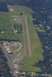
By: chabrier


