Login
Register


LEE
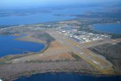
Leesburg International Airport
Official FAA Data Effective 2026-02-19 0901Z
Chart Supplement

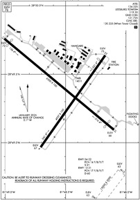
KLEE Airport Diagram
VFR Chart of KLEE
Sectional Charts at SkyVector.com
IFR Chart of KLEE
Enroute Charts at SkyVector.com
Location Information for KLEE
Coordinates: N28°49.37' / W81°48.51'Located 03 miles NE of Leesburg, Florida on 818 acres of land. View all Airports in Florida.
Surveyed Elevation is 76 feet MSL.
Operations Data
|
|
Airport Communications
| ATIS: | 134.325 |
|---|---|
| ASOS: | Tel. 352-787-1565 |
| LEESBURG TOWER: | 119.35 |
| LEESBURG GROUND: | 121.725 |
| ORLANDO APPROACH: | 120.225 135.3 351.9 |
| ORLANDO DEPARTURE: | 120.225 135.3 351.9 |
| IC: | 135.3 |
| CLEARANCE DELIVERY: | 120.225 ;WHEN TWR CLSD |
| ALYNA STAR: | 124.8 307.0 |
| RIDES STAR: | 128.375 338.2 |
| CTAF: | 119.350 |
| UNICOM: | 122.725 |
| MINEE STAR: | 134.05 339.8 |
| JOKRS STAR: | 134.05 339.8 |
| TTHOR STAR: | 118.85 353.825 125.225 351.9 |
| PRICY STAR: | 134.05 339.8 |
| AWOS-3 at INF (26.9 W): | 119.975 352-560-6012 |
| ASOS at SFB (30.0 E): | 125.975 407-321-9384 |
| ATIS at ORL (30.1 SE): | 127.25 |
Nearby Navigation Aids
|
| ||||||||||||||||||||||||||||||||||||||||||||||||


Runway 03W/21W
| Dimensions: | 15000 x 2000 feet / 4572 x 610 meters | |
|---|---|---|
| Surface: | Water | |
| Runway 03W | Runway 21W | |
| Elevation: | 63.0 | 63.0 |
Runway 13/31
25 FT PAVED SHOULDERS EACH SIDE. TREES ALG SW SIDE OF RWY IN TRSN SFC. | ||
| Dimensions: | 6300 x 100 feet / 1920 x 30 meters | |
|---|---|---|
| Surface: | Asphalt / Grooved in Good Condition | |
| Weight Limits: | 17 /F/B/Y/T, D-60 | |
| Edge Lighting: | Medium Intensity | |
| Runway 13 | Runway 31 | |
| Coordinates: | N28°49.76' / W81°49.01' | N28°49.10' / W81°48.10' |
| Elevation: | 72.1 | 66.3 |
| Traffic Pattern: | Left | Left |
| Runway Heading: | 130° True | 310° True |
| Displaced Threshold: | 290 Feet | 400 Feet |
| Declared Distances: | TORA:6300 TODA:6300 ASDA:5500 LDA:5211 | TORA:6300 TODA:6300 ASDA:6000 LDA:5600 |
| Markings: | Non-Precision Instrument in good condition. | Non-Precision Instrument in good condition. |
| Glide Slope Indicator | P4L (3.00° Glide Path Angle) | P4L (3.00° Glide Path Angle) |
| REIL: | Yes | Yes |
| Obstacles: | 64 ft Trees 1870 ft from runway, 250 ft left of center APCH SLP 34:1 TO DTHR. |
5 ft Brush 200 ft from runway, 170 ft left of center CONTROLLING OBSTN EXCEEDS A 45 DEG SLP. APCH SLP 20:1 TO DTHR. BRUSH 5 FT TALL 200 FT BEFORE TO 920 FT AFTER AER INSIDE PRI SFC. |
Runway 04/22
| Dimensions: | 4957 x 100 feet / 1511 x 30 meters | |
|---|---|---|
| Surface: | Asphalt in Good Condition | |
| Weight Limits: | 14 /F/B/Y/T, S-21 | |
| Edge Lighting: | Medium Intensity | |
| Runway 04 | Runway 22 | |
| Coordinates: | N28°48.97' / W81°48.71' | N28°49.64' / W81°48.17' |
| Elevation: | 66.7 | 75.2 |
| Traffic Pattern: | Left | Left |
| Runway Heading: | 35° True | 215° True |
| Displaced Threshold: | 310 Feet | |
| Declared Distances: | TORA:4957 TODA:4957 ASDA:4688 LDA:4688 | TORA:4957 TODA:4957 ASDA:4957 LDA:4647 |
| Markings: | Non-Precision Instrument in good condition. | Basic in good condition. |
| Glide Slope Indicator | P4L (3.00° Glide Path Angle) | P4R (3.00° Glide Path Angle) |
| Obstacles: | 9 ft Brush 200 ft from runway, 80 ft left of center BRUSH/TREES INSIDE PRI SFC 80 FT TO 250 FT L OF CL WITHIN FIRST 700 FT. 25 FT TREES 235 FT LEFT OF CNTRLN 100 FT FM RWY END. |
11 ft Berm 81 ft from runway CONTROLLING OBSTN EXCEEDS A 45 DEG SLP. APCH SLP 21:1 TO DTHR. 11 FT BERM FULL WID OF RWY 81 FT FM RWY END. |
Services Available
| Fuel: | 100LL (blue), Jet-A |
|---|---|
| Transient Storage: | Hangars,Tiedowns |
| Airframe Repair: | MAJOR |
| Engine Repair: | MAJOR |
| Bottled Oxygen: | LOW |
| Bulk Oxygen: | NONE |
| Other Services: | CROP DUSTING SERVICES,AVIONICS,CHARTER SERVICE,PILOT INSTRUCTION,AIRCRAFT RENTAL,AIRCRAFT SALES |
Ownership Information
| Ownership: | Publicly owned | |
|---|---|---|
| Owner: | CITY OF LEESBURG | |
| PO BOX 490630 | ||
| LEESBURG, FL 34749-0630 | ||
| 352-516-7236 | ||
| Manager: | TRACEY DEAN | |
| PO BOX 490630 | ||
| LEESBURG, FL 34749 | ||
| 352-728-9801 | EXT 1130 OR 352-728-9786. | |
Other Remarks
- BIRD ACT INVOF ARPT.
- UNLGTD 30 FT OBSTNS 440 FT BFR AER RWY 04.
- 24 HR PPR FOR ACFT EQUIPPED WITH WEATHER MODIFICATION OR GEOENGINEERING EQPT 352-516-7236.
- TREES 235 FT W OF CNTRLN FOR FIRST 1000 FT INSIDE PRI SFC.
- 0LL 24 HR SELF SERVE.
- ACTVT REILS 13 & 31; PAPI RWYS 04, 22, 13 & 31; MIRL RWYS 04/22 & 13/31 - CTAF. TWY LGTS OPR DUSK - 2200; AFT 2200 ACTVT - CTAF.
Weather Minimums

Standard Terminal Arrival (STAR) Charts


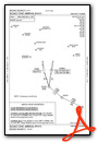
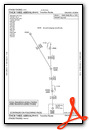

Instrument Approach Procedure (IAP) Charts


Nearby Airports with Instrument Procedures
| ID | Name | Heading / Distance | ||
|---|---|---|---|---|
 |
X23 | Umatilla Municipal Airport | 053° | 10.3 |
|
X04 | Orlando Apopka Airport | 119° | 13.8 |
|
KINF | Inverness Airport | 267° | 26.9 |
|
KORL | Orlando Exec Airport | 123° | 30.1 |
|
KOCF | Ocala International-Jim Taylor Field Airport | 313° | 30.2 |
|
KSFB | Orlando Sanford International Airport | 095° | 30.4 |
|
KDED | Deland Municipal-Sidney H Taylor Field Airport | 061° | 31.2 |
|
X35 | Marion County Airport | 295° | 33.2 |
|
KMCO | Orlando International Airport | 131° | 35.4 |
|
KISM | Kissimmee Gateway Airport | 148° | 37.5 |
|
KBKV | Brooksville-Tampa Bay Regional Airport | 238° | 40.1 |
|
KZPH | Zephyrhills Municipal Airport | 207° | 40.1 |