Login
Register
JXN
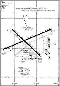
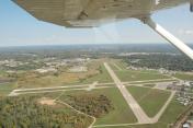
Jackson County/Reynolds Field Airport
Official FAA Data Effective 2026-01-22 0901Z
VFR Chart of KJXN
Sectional Charts at SkyVector.com
IFR Chart of KJXN
Enroute Charts at SkyVector.com
Location Information for KJXN
Coordinates: N42°15.63' / W84°27.73'Located 02 miles W of Jackson, Michigan on 950 acres of land. View all Airports in Michigan.
Surveyed Elevation is 1000 feet MSL.
Operations Data
|
|
Airport Communications
| ATIS: | 125.725 |
|---|---|
| ASOS: | Tel. 517-768-7506 |
| JACKSON TOWER: | 128.475 257.8 |
| JACKSON GROUND: | 121.9 |
| GREAT LAKES APPROACH: | 127.3 335.575 |
| GREAT LAKES DEPARTURE: | 127.3 335.575 |
| CLEARANCE DELIVERY: | 121.9 |
| EMERG: | 121.5 243.0 |
| CTAF: | 128.475 |
| UNICOM: | 122.950 |
| AWOS-3P at TEW (18.3 N): | 119.425 517-676-5607 |
| AWOS-3 at JYM (21.1 S): | 121.025 517-437-5638 |
| AWOS-3 at RMY (21.9 W): | 120.025 269-781-9070 |
- APCH/DEP SVC PRVDD BY CLEVELAND ARTCC (ZOB) ON FREQS 120.45/360.7 (LITCHFIELD RCAG) WHEN GREAT LAKES APCH CTL CLSD.
Nearby Navigation Aids
|
| ||||||||||||||||||||||||||||||||||||||||||||||||||||||||||||
Runway 07/25
| Dimensions: | 5351 x 100 feet / 1631 x 30 meters | |
|---|---|---|
| Surface: | Asphalt / Grooved in Excellent Condition | |
| Weight Limits: | 30 /F/C/X/U, S-76, D-100, ST-180 | |
| Edge Lighting: | High Intensity | |
| Runway 07 | Runway 25 | |
| Coordinates: | N42°15.48' / W84°28.27' | N42°15.82' / W84°27.17' |
| Elevation: | 985.0 | 993.9 |
| Traffic Pattern: | Left | Left |
| Runway Heading: | 67° True | 247° True |
| Markings: | Precision Instrument in good condition. | Precision Instrument in good condition. |
| Glide Slope Indicator | P4L (3.00° Glide Path Angle) | P4L (3.00° Glide Path Angle) |
| Approach Lights: | MALSR 1,400 Foot Medium-intensity Approach Lighting System with runway alignment indicator lights. | |
| REIL: | Yes | |
| Obstacles: | 72 ft Power Line 1613 ft from runway, 660 ft right of center | 94 ft Trees 2758 ft from runway, 773 ft left of center |
Runway 14/32
| Dimensions: | 4000 x 100 feet / 1219 x 30 meters | |
|---|---|---|
| Surface: | Asphalt / Grooved in Good Condition | |
| Weight Limits: | 16 /F/C/X/U, S-42, D-62, ST-115 | |
| Edge Lighting: | Medium Intensity | |
| Runway 14 | Runway 32 | |
| Coordinates: | N42°15.83' / W84°28.06' | N42°15.37' / W84°27.42' |
| Elevation: | 972.1 | 1000.6 |
| Traffic Pattern: | Left | Left |
| Runway Heading: | 133° True | 313° True |
| Markings: | Non-Precision Instrument in good condition. | Non-Precision Instrument in good condition. |
| Glide Slope Indicator | P4L (3.00° Glide Path Angle) | P4L (3.50° Glide Path Angle) |
| REIL: | Yes | |
| Obstacles: | 20 ft Tree 438 ft from runway, 125 ft left of center | 89 ft Tree 1924 ft from runway, 100 ft right of center |
Services Available
| Fuel: | 100LL (blue), Jet A+ |
|---|---|
| Transient Storage: | Hangars,Tiedowns |
| Airframe Repair: | MAJOR |
| Engine Repair: | MAJOR |
| Bottled Oxygen: | NONE |
| Bulk Oxygen: | NONE |
| Other Services: | PILOT INSTRUCTION |
Ownership Information
| Ownership: | Publicly owned | |
|---|---|---|
| Owner: | JACKSON COUNTY | |
| 120 W MICHIGAN AVE, JACKSON CO TOWER BLDG 5TH FL | ||
| JACKSON, MI 49201-1338 | ||
| 517-788-4335 | ||
| Manager: | JUAN ZAPATA | |
| 3606 WILDWOOD AVE | ||
| JACKSON, MI 49202-1864 | ||
| 517-788-4225 | ||
Other Remarks
- DEER & LRG BIRDS ON & INVOF ARPT.
- LOW ALT HEL OPS PROHIBITED INVOF PRISON 4 MI NE.
- WINTER FICONS UNMON WHEN ATCT CLSD.
- ACFT TAXIING UP TWY D COULD POSSLY MISS THE TURN FOR TWY A & VIOLATE THE SAFETY ZONE FOR RWY 07/25.
- FOR CD WHEN ATCT CLSD CTC GREAT LAKES APCH AT 269-459-3345, WHEN APCH CLSD CTC CLEVELAND ARTCC AT 440-774-0224/0490.
- 0LL 100LL & JET A+ AVBL SELF SVC ON MAIN RAMP.
- WHEN ATCT CLSD ACTVT MALSR RWY 25; REIL RWY 07 & 32; PAPI RWY 07, 25, 14 & 32; HIRL RWY 07/25; MIRL RWY 14/32 - CTAF.
Weather Minimums
Instrument Approach Procedure (IAP) Charts
Nearby Airports with Instrument Procedures
| ID | Name | Heading / Distance | ||
|---|---|---|---|---|
 |
KTEW | Mason Jewett Field Airport | 005° | 18.4 |
 |
KJYM | Hillsdale Municipal Airport | 195° | 21.1 |
 |
KRMY | Brooks Field Airport | 268° | 22.0 |
 |
KFPK | Fitch H Beach Airport | 320° | 24.4 |
 |
KADG | Lenawee County Airport | 143° | 29.2 |
 |
KOZW | Livingston County/Spencer J Hardy Airport | 043° | 30.7 |
 |
KLAN | Capital Region International Airport | 349° | 31.6 |
 |
KARB | Ann Arbor Municipal Airport | 093° | 32.0 |
 |
KOEB | Branch County Memorial Airport | 233° | 32.9 |
 |
4D0 | Abrams Municipal Airport | 338° | 33.1 |
 |
KBTL | Battle Creek Exec At Kellogg Field Airport | 274° | 35.2 |
 |
Y47 | Oakland Southwest Airport | 068° | 40.0 |


