Login
Register


4D0
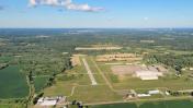
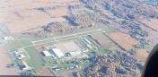
Abrams Municipal Airport
Official FAA Data Effective 2026-01-22 0901Z
Chart Supplement

VFR Chart of 4D0
Sectional Charts at SkyVector.com
IFR Chart of 4D0
Enroute Charts at SkyVector.com
Location Information for 4D0
Coordinates: N42°46.49' / W84°43.99'Located 02 miles N of Grand Ledge, Michigan on 160 acres of land. View all Airports in Michigan.
Surveyed Elevation is 841 feet MSL.
Operations Data
|
|
Airport Communications
| GREAT LAKES APPROACH: | 118.65 226.4 |
|---|---|
| GREAT LAKES DEPARTURE: | 118.65 226.4 |
| CTAF: | 122.700 |
| UNICOM: | 122.700 |
| ASOS at LAN (5.9 E): | 517-908-8494 |
| ATIS at LAN (6.5 E): | 119.75 |
| AWOS-3P at FPK (12.4 S): | 118.075 517-543-2288 |
- APCH/DEP SVC PRVDD BY CLEVELAND ARTCC (ZOB) ON FREQS 126.75/348.75 (FLINT RCAG) WHEN GREAT LAKES APCH CTL CLSD.
Nearby Navigation Aids
|
| ||||||||||||||||||||||||||||||||||||||||||||||||||||||||||||


Runway 09/27
| Dimensions: | 3200 x 75 feet / 975 x 23 meters | |
|---|---|---|
| Surface: | Asphalt in Good Condition | |
| Edge Lighting: | Medium Intensity | |
| Runway 09 | Runway 27 | |
| Coordinates: | N42°46.52' / W84°44.16' | N42°46.56' / W84°43.44' |
| Elevation: | 830.5 | 840.0 |
| Traffic Pattern: | Left | Left |
| Runway Heading: | 86° True | 266° True |
| Markings: | Non-Precision Instrument in fair condition. | Non-Precision Instrument in fair condition. |
| Glide Slope Indicator | P4L (4.00° Glide Path Angle) UNUSBL BYD 5 DEGS RIGHT OF CNTRLN. | P2L (4.00° Glide Path Angle) |
| REIL: | Yes | |
| Obstacles: | 49 ft Tree 1003 ft from runway, 380 ft left of center | 14 ft Brush 353 ft from runway, 204 ft left of center 4 FT HILL, 30-199 FT DIST, 125-250 FT L. |
Runway 18/36
| Dimensions: | 2560 x 120 feet / 780 x 37 meters | |
|---|---|---|
| Surface: | Turf in Fair Condition | |
| Runway 18 | Runway 36 | |
| Coordinates: | N42°46.65' / W84°44.22' | N42°46.23' / W84°44.22' |
| Elevation: | 828.3 | 836.8 |
| Traffic Pattern: | Left | Left |
| Runway Heading: | 180° True | 360° True |
| Displaced Threshold: | 388 Feet | 387 Feet |
| Obstacles: | 8 ft Trees 50 ft from runway, 130 ft right of center | 17 ft Road 45 ft from runway |
Services Available
| Fuel: | 100LL (blue) |
|---|---|
| Transient Storage: | Hangars,Tiedowns |
| Airframe Repair: | MAJOR |
| Engine Repair: | MAJOR |
| Bottled Oxygen: | NONE |
| Bulk Oxygen: | NONE |
| Other Services: | CHARTER SERVICE,PILOT INSTRUCTION,AIRCRAFT RENTAL |
Ownership Information
| Ownership: | Publicly owned | |
|---|---|---|
| Owner: | CITY OF GRAND LEDGE | |
| 310 GREENWOOD ST | ||
| GRAND LEDGE, MI 48837-1651 | ||
| 517-627-2149 | ||
| Manager: | AMEE KING, ASST CITY MGR | |
| 310 GREENWOOD ST | ||
| GRAND LEDGE, MI 48837-1651 | ||
| 517-622-7925 | ||
Other Remarks
- MILITARY: RNG: NO FIXED WING & LTD ROTARY WING PRKG ON AASF RAMP.
- CTC AIRFIELD OPS ON 41.85/122.7/241.0.
- FOR CD CTC GREAT LAKES APCH AT 269-459-3345, WHEN APCH CLSD CTC CLEVELAND ARTCC AT 440-774-0224/0490.
- TPA 1900 FT MSL FOR FW; 1700 FT MSL FOR HEL.
- DEER & LRG BIRDS ON & INVOF ARPT.
- INTSV NG HELICOPTER TRG ON & INVOF ARPT. HELICOPTERS AVOID FLOW OF FIXED WING ACFT PER 14 CFR 91.126.
- AVOID OVERFLIGHT OF GRAND LEDGE BLW 2000 FT.
- ACTVT REIL RWY 27; PAPI RWY 09 & 27; MIRL RWY 09/27 - CTAF.
Weather Minimums

Instrument Approach Procedure (IAP) Charts
Nearby Airports with Instrument Procedures
| ID | Name | Heading / Distance | ||
|---|---|---|---|---|
 |
KLAN | Capital Region International Airport | 087° | 6.5 |
|
KFPK | Fitch H Beach Airport | 196° | 12.5 |
|
Y70 | Ionia County Airport | 304° | 17.4 |
|
KTEW | Mason Jewett Field Airport | 132° | 18.6 |
|
9D9 | Hastings Airport | 256° | 27.9 |
|
KRNP | Owosso Community Airport | 063° | 29.3 |
|
6D6 | Greenville Municipal Airport | 314° | 31.8 |
|
KAMN | Gratiot Community Airport | 003° | 32.9 |
|
KRMY | Brooks Field Airport | 197° | 32.9 |
|
KJXN | Jackson County/Reynolds Field Airport | 158° | 33.1 |
|
KOZW | Livingston County/Spencer J Hardy Airport | 104° | 34.3 |
|
KGRR | Gerald R Ford International Airport | 280° | 35.4 |