Login
Register
BPI
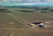
Miley Memorial Field Airport
Official FAA Data Effective 2026-01-22 0901Z
VFR Chart of KBPI
Sectional Charts at SkyVector.com
IFR Chart of KBPI
Enroute Charts at SkyVector.com
Location Information for KBPI
Coordinates: N42°34.93' / W110°6.53'Located 03 miles N of Big Piney, Wyoming on 1199 acres of land. View all Airports in Wyoming.
Surveyed Elevation is 6993 feet MSL.
Operations Data
|
|
Airport Communications
| ASOS: | 135.225 Tel. 307-276-9917 |
|---|---|
| CTAF: | 122.800 |
| UNICOM: | 122.800 |
| AWOS-3 at PNA (18.4 NE): | 118.325 307-367-6425 |
| AWOS-3P at AFO (37.7 W): | 119.025 307-885-2654 |
| AWOS-3PT at EMM (49.7 SW): | 119.675 307-877-9838 |
- COMMUNICATIONS PRVDD BY CASPER RADIO 122.3 (BIG PINEY RCO).
- APCH/DEP CTL SVC PRVDD BY SALT LAKE ARTCC (ZLC) ON 128.35/239.25 (BIG PINEY RCAG).
Nearby Navigation Aids
|
| ||||||||||||||||||||||||||||||||||||
Runway 13/31
| Dimensions: | 6803 x 75 feet / 2074 x 23 meters | |
|---|---|---|
| Surface: | Asphalt in Good Condition | |
| Weight Limits: | 31 /F/A/X/T, S-45, D-60 | |
| Edge Lighting: | Medium Intensity | |
| Runway 13 | Runway 31 | |
| Coordinates: | N42°35.58' / W110°7.07' | N42°34.63' / W110°6.26' |
| Elevation: | 6993.6 | 6948.8 |
| Traffic Pattern: | Left | Left |
| Runway Heading: | 148° True | 328° True |
| Markings: | Non-Precision Instrument in good condition. | Non-Precision Instrument in good condition. |
| Glide Slope Indicator | P2L (3.00° Glide Path Angle) | P2L (3.00° Glide Path Angle) |
| REIL: | Yes | Yes |
Runway 08/26
| Dimensions: | 3301 x 60 feet / 1006 x 18 meters | |
|---|---|---|
| Surface: | Turf-Dirt in Good Condition | |
| Runway 08 | Runway 26 | |
| Coordinates: | N42°34.60' / W110°6.62' | N42°34.57' / W110°5.88' |
| Elevation: | 6943.4 | 6935.8 |
| Traffic Pattern: | Left | Left |
| Runway Heading: | 93° True | 273° True |
| Markings: | None | None |
| Obstacles: | 17 ft Pole 798 ft from runway, 21 ft right of center | |
Services Available
| Fuel: | 100LL (blue), Jet-A |
|---|---|
| Transient Storage: | Hangars,Tiedowns |
| Airframe Repair: | NONE |
| Engine Repair: | NONE |
| Bottled Oxygen: | NONE |
| Bulk Oxygen: | NONE |
Ownership Information
| Ownership: | Publicly owned | |
|---|---|---|
| Owner: | BIG PINEY-MARBLETON AIRPORT BOARD | |
| P.O. BOX 307 | ||
| BIG PINEY, WY 83113 | ||
| (307) 276-4022 | ||
| Manager: | JOSH ROSE | |
| P.O. BOX 307 | ||
| BIG PINEY, WY 83113 | ||
| 307-231-6244 | ||
Other Remarks
- RY 08/26 NO LINE OF SIGHT.
- FOR CD IF UNA TO CTC ON FSS FREQ, CTC SALT LAKE ARTCC AT 801-320-2568.
- FUEL 24 HR CREDIT CARD SVC AVBL. JET A TRUCK ALSO AVBL.
- ACTVT REIL RWYS 13 & 31; PAPI RWYS 13 & 31; MIRL RWY 13/31 - 122.7.
Weather Minimums
Instrument Approach Procedure (IAP) Charts
Nearby Airports with Instrument Procedures
| ID | Name | Heading / Distance | ||
|---|---|---|---|---|
 |
KPNA | Ralph Wenz Field Airport | 045° | 18.4 |
 |
KAFO | Afton Lincoln County/General Boyd L Eddins Field Airport | 281° | 37.7 |
 |
KEMM | Kemmerer Municipal Airport | 203° | 49.7 |
 |
1U7 | Bear Lake County Airport | 250° | 58.3 |
 |
KDUB | Dubois Municipal Airport | 017° | 60.8 |
 |
KLND | Hunt Field Airport | 076° | 62.6 |
 |
KJAC | Jackson Hole Airport | 336° | 67.4 |
 |
KFBR | Fort Bridger Airport | 190° | 72.5 |
 |
KRKS | Southwest Wyoming Regional Airport | 141° | 75.4 |
 |
KRIW | Central Wyoming Regional Airport | 067° | 78.3 |
 |
KDIJ | Driggs/Reed Memorial Airport | 328° | 82.1 |
 |
KEVW | Evanston-Uinta County Burns Field Airport | 208° | 88.7 |


Comments
Excellent runway and very