Login
Register
RIW
Central Wyoming Regional Airport
Official FAA Data Effective 2025-12-25 0901Z
VFR Chart of KRIW
Sectional Charts at SkyVector.com
IFR Chart of KRIW
Enroute Charts at SkyVector.com
Location Information for KRIW
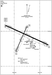
Coordinates: N43°3.85' / W108°27.59'Located 03 miles NW of Riverton, Wyoming on 1250 acres of land. View all Airports in Wyoming.
Surveyed Elevation is 5516 feet MSL.
Operations Data
|
|
Airport Communications
| ASOS: | 121.425 Tel. 307-556-2831 |
|---|---|
| UNICOM: | 122.800 |
| CTAF: | 122.800 |
| ASOS at LND (19.0 SW): | 118.15 307-216-3738 |
| AWOS-3PT at TBX (25.9 N): | 119.150 307-709-4487 |
| AWOS-3PT at FWZ (35.9 SW): | 118.350 307-709-2644 |
- APCH/DEP CTL SVC PRVDD BY SALT LAKE ARTCC (ZLC) ON FREQS 133.25/285.6 (BOYSEN RCAG).
Nearby Navigation Aids
|
| ||||||||||||||||||||||||||||||||||||
Runway 10/28
| Dimensions: | 8204 x 150 feet / 2501 x 46 meters | |
|---|---|---|
| Surface: | Asphalt / Grooved in Good Condition | |
| Weight Limits: | S-85, D-110, ST-165
PCR VALUE: 280/F/B/X/T
| |
| Edge Lighting: | High Intensity | |
| Runway 10 | Runway 28 | |
| Coordinates: | N43°4.17' / W108°28.35' | N43°3.62' / W108°26.67' |
| Elevation: | 5516.0 | 5442.9 |
| Traffic Pattern: | Left | Left |
| Runway Heading: | 114° True | 294° True |
| Declared Distances: | TORA:8204 TODA:8204 ASDA:8204 LDA:8204 | TORA:8204 TODA:8204 ASDA:8204 LDA:8204 |
| Markings: | Precision Instrument in good condition. | Precision Instrument in good condition. |
| Glide Slope Indicator | P4L (3.00° Glide Path Angle) | P4R (3.00° Glide Path Angle) |
| Approach Lights: | MALSR 1,400 Foot Medium-intensity Approach Lighting System with runway alignment indicator lights. | |
| REIL: | Yes | |
| Obstacles: | 133 ft Power Line 3950 ft from runway | |
Runway 01/19
| Dimensions: | 4800 x 75 feet / 1463 x 23 meters | |
|---|---|---|
| Surface: | Asphalt / Grooved in Good Condition | |
| Weight Limits: | S-30, D-50
PCR VALUE: 140/F/D/X/T
| |
| Edge Lighting: | Medium Intensity | |
| Runway 01 | Runway 19 | |
| Coordinates: | N43°3.42' / W108°27.94' | N43°4.14' / W108°27.50' |
| Elevation: | 5462.8 | 5479.9 |
| Runway Heading: | 24° True | 204° True |
| Declared Distances: | TORA:4800 TODA:4800 ASDA:4800 LDA:4800 | TORA:4800 TODA:4800 ASDA:4800 LDA:4800 |
| Markings: | Non-Precision Instrument in good condition. | Non-Precision Instrument in good condition. |
| Glide Slope Indicator | P2L (3.00° Glide Path Angle) | P2L (3.00° Glide Path Angle) |
| REIL: | Yes | Yes |
| Obstacles: | ft Power Line ft from runway | |
Services Available
| Fuel: | 100LL (blue), Jet-A |
|---|---|
| Transient Storage: | Hangars,Tiedowns |
| Airframe Repair: | MAJOR |
| Engine Repair: | MAJOR |
| Bottled Oxygen: | LOW |
| Bulk Oxygen: | NOT AVAILABLE |
| Other Services: | AIR FREIGHT SERVICES,CROP DUSTING SERVICES,CHARTER SERVICE,PILOT INSTRUCTION |
Ownership Information
| Ownership: | Publicly owned | |
|---|---|---|
| Owner: | CITY OF RIVERTON | |
| 816 N FEDERAL BLVD. | ||
| RIVERTON, WY 82501 | ||
| (307) 857-7780 | ||
| Manager: | BRUCE RANSOM | |
| 816 NORTH FEDERAL BLVD | ||
| RIVERTON, WY 82501 | ||
| 307-857-7780 | ||
Other Remarks
- GA ACFT NOT AUZD ON WEST RAMP.
- MULTIPLE HOT AIR BALLOONS INVOF ARPT DURING JULY.
- CONDS NOT MONITORED AT NGT AFT THE LAST ACR ARR TIL 0500L. SEE NOTAMS FOR THE MOST UP-TO-DATE CONDS AND UPDTS.
- FOR CD IF UNA TO CTC ON FSS FREQ, CTC SALT LAKE ARTCC AT 801-320-2568.
- ACTVT HIRL RY 10/28; MIRL RY 01/19; REIL RY 01 & RY 19; AND REIL RY 10; MALSR RY 28 - CTAF. PAPI RY 01, RY 19, RY 10 & RY 28 OPER 24 HRS.
Weather Minimums
Instrument Approach Procedure (IAP) Charts
Nearby Airports with Instrument Procedures
| ID | Name | Heading / Distance | ||
|---|---|---|---|---|
 |
KLND | Hunt Field Airport | 218° | 19.1 |
 |
KHSG | Hot Springs County Airport | 004° | 39.1 |
 |
KWRL | Worland Municipal Airport | 022° | 58.3 |
 |
KDUB | Dubois Municipal Airport | 298° | 61.3 |
 |
KPNA | Ralph Wenz Field Airport | 255° | 61.7 |
 |
KBPI | Miley Memorial Field Airport | 248° | 78.3 |
 |
KCPR | Casper/Natrona County International Airport | 095° | 88.4 |
 |
KGEY | South Big Horn County Airport | 010° | 88.7 |
 |
KCOD | Yellowstone Regional Airport | 344° | 90.7 |
 |
KRKS | Southwest Wyoming Regional Airport | 197° | 92.2 |
 |
KRWL | Rawlins Municipal/Harvey Field Airport | 143° | 94.0 |
 |
KJAC | Jackson Hole Airport | 288° | 104.9 |


