Login
Register


CAD
Wexford County Airport
Official FAA Data Effective 2025-11-27 0901Z
Chart Supplement

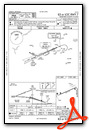
VFR Chart of KCAD
Sectional Charts at SkyVector.com
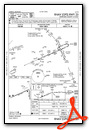
IFR Chart of KCAD
Enroute Charts at SkyVector.com
Location Information for KCAD
Coordinates: N44°16.52' / W85°25.14'Located 02 miles NNW of Cadillac, Michigan on 441 acres of land. View all Airports in Michigan.
Surveyed Elevation is 1306 feet MSL.
Operations Data
|
|
Airport Communications
| AWOS-3P: | 128.325 Tel. 231-779-9536 |
|---|---|
| UNICOM: | 122.800 |
| CTAF: | 122.800 |
| ASOS at TVC (28.6 N): | 231-486-2920 |
| ATIS at TVC (28.8 N): | 119.175 |
| ASOS at HTL (32.4 E): | 118.05 989-200-3352 |
- APCH/DEP SVC PRVDD BY MINNEAPOLIS ARTCC ON 132.9/338.3 (TRAVERSE CITY RCAG).
Nearby Navigation Aids
|
| ||||||||||||||||||||||||||||||||||||||||||||||||||||||||||||


Runway 07/25
| Dimensions: | 5001 x 100 feet / 1524 x 30 meters | |
|---|---|---|
| Surface: | Asphalt / Porous Friction Course in Good Condition | |
| Weight Limits: | S-30, D-45 | |
| Edge Lighting: | High Intensity | |
| Runway 07 | Runway 25 | |
| Coordinates: | N44°16.37' / W85°25.85' | N44°16.70' / W85°24.80' |
| Elevation: | 1306.5 | 1297.9 |
| Traffic Pattern: | Left | Left |
| Runway Heading: | 66° True | 246° True |
| Markings: | Precision Instrument in good condition. | Precision Instrument in good condition. |
| Glide Slope Indicator | V4L (3.00° Glide Path Angle) | P4L (3.00° Glide Path Angle) |
| Approach Lights: | MALSF 1,400 Foot Medium-intensity Approach Lighting System with sequenced flashers. | |
| REIL: | Yes | Yes |
| Obstacles: | 42 ft Tree 901 ft from runway, 372 ft right of center | 37 ft Pole 1372 ft from runway, 626 ft right of center |
Runway 18/36
CLSD DEC-MAR & WHEN SNOW COVD EXC FOR SKI EQUIPPED ACFT. | ||
| Dimensions: | 1986 x 150 feet / 605 x 46 meters | |
|---|---|---|
| Surface: | Turf in Fair Condition | |
| Runway 18 | Runway 36 | |
| Coordinates: | N44°16.64' / W85°24.66' | N44°16.31' / W85°24.66' |
| Elevation: | 1293.7 | 1296.5 |
| Traffic Pattern: | Left | Left |
| Runway Heading: | 179° True | 359° True |
| Obstacles: | 51 ft Tree 1153 ft from runway, 237 ft left of center | |
Services Available
| Fuel: | 100LL (blue), Jet-A |
|---|---|
| Transient Storage: | Hangars,Tiedowns |
| Airframe Repair: | MAJOR |
| Engine Repair: | MAJOR |
| Bottled Oxygen: | NOT AVAILABLE |
| Bulk Oxygen: | NOT AVAILABLE |
| Other Services: | GLIDER SERVICE,PILOT INSTRUCTION,GLIDER TOWING SERVICES |
Ownership Information
| Ownership: | Publicly owned | |
|---|---|---|
| Owner: | WEXFORD CO ARPT AUTH | |
| 8040 E 34 RD | ||
| CADILLAC, MI 49601-9015 | ||
| 231-779-9525 | ||
| Manager: | KEITH NEWELL | |
| 8040 E 34 RD | ||
| CADILLAC, MI 49601-9015 | ||
| 231-878-5178 | CELL. | |
Other Remarks
- DEER & LRG BIRDS ON & INVOF ARPT.
- ADMIN BLDG EAST DOOR ACES 5-3-2-1.
- GLDR & ULTRALIGHT ACT ON & INVOF ARPT APR-OCT.
- FOR CD CTC MINNEAPOLIS ARTCC AT 651-463-5588.
- LDG FEE FOR COML OPS WAIVED WITH MNM FUEL PURCHASE.
- 3 FT YELLOW CONES.
- 3 FT YELLOW CONES.
- 0LL AVBL H24 SELF SVC.
- ACTVT MALSF RWY 07; REIL RWY 07 & 25; VASI RWY 07; PAPI RWY 25; HIRL RWY 07/25 - CTAF.
Weather Minimums


Instrument Approach Procedure (IAP) Charts

Nearby Airports with Instrument Procedures
| ID | Name | Heading / Distance | ||
|---|---|---|---|---|
 |
KTVC | Cherry Capital Airport | 346° | 28.8 |
|
7D3 | Baldwin Municipal Airport | 217° | 30.2 |
|
KHTL | Roscommon County/Blodgett Memorial Airport | 080° | 32.7 |
|
KRQB | Roben-Hood Airport | 186° | 33.4 |
|
KMBL | Manistee County/Blacker Airport | 270° | 35.7 |
|
KGOV | Grayling AAF Airport | 050° | 38.3 |
|
48D | Clare Municipal Airport | 131° | 39.5 |
|
KFKS | Frankfort Dow Memorial Field Airport | 302° | 39.6 |
|
KACB | Antrim County Airport | 012° | 43.8 |
|
KGDW | Gladwin Zettel Memorial Airport | 113° | 44.7 |
|
KLDM | Mason County Airport | 246° | 46.7 |
|
KMOP | Mount Pleasant Municipal Airport | 142° | 49.1 |
Airport Images
Do you have a recent image of this airport? Upload it here!


