Login
Register


GYR
Phoenix Goodyear Airport
Official FAA Data Effective 2026-01-22 0901Z
Chart Supplement

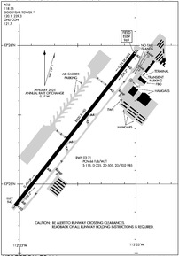
KGYR Airport Diagram
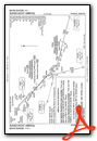
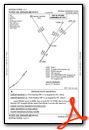
VFR Chart of KGYR
Sectional Charts at SkyVector.com
IFR Chart of KGYR
Enroute Charts at SkyVector.com
Location Information for KGYR
Coordinates: N33°25.40' / W112°22.52'Located 01 miles SW of Goodyear, Arizona on 789 acres of land. View all Airports in Arizona.
Surveyed Elevation is 969 feet MSL.
1968(1000) LIGHT ACFT & NON-TURBO JETS; 2468(1500) HEAVY ACFT & TURBO JETS; HELICOPTERS 1468(500).
Operations Data
|
|
Airport Communications
| ATIS: | 118.35 |
|---|---|
| GOODYEAR TOWER: | 120.1 239.3 |
| GOODYEAR GROUND: | 121.7 |
| LUKE APPROACH: | 125.45 ;SOUTH 263.125 ;SOUTH 120.7 239.0 |
| LUKE DEPARTURE: | 125.45 ;SOUTH 263.125 ;SOUTH 120.7 239.0 |
| UNICOM: | 122.950 |
| CTAF: | 120.100 |
| DSERT STAR: | 120.7 |
| SUNSS STAR: | 124.1 256.9 |
| ATIS at LUF (6.7 N): | 134.925 |
| AWOS-3 at GEU (7.4 NE): | 623-877-8609 |
| ATIS at GEU (7.4 NE): | 119.425 |
- EMERG FREQ 121.5 NOT AVBL AT ATCT.
- COMMUNICATIONS PRVDD BY PRESCOTT RADIO ON FREQ 122.2 (PHOENIX RCO).
Nearby Navigation Aids
|
| ||||||||||||||||||||||||||||||||||||

Runway 03/21
| Dimensions: | 8500 x 150 feet / 2591 x 46 meters | |
|---|---|---|
| Surface: | Asphalt in Good Condition | |
| Weight Limits: | 66 /F/B/W/T, S-115, D-225, ST-505, DT-985 | |
| Edge Lighting: | Medium Intensity | |
| Runway 03 | Runway 21 | |
| Coordinates: | N33°24.85' / W112°23.04' | N33°25.95' / W112°22.01' |
| Elevation: | 942.8 | 969.1 |
| Traffic Pattern: | Left | Right |
| Runway Heading: | 38° True | 218° True |
| Markings: | Precision Instrument in good condition. | Precision Instrument in good condition. |
| Glide Slope Indicator | P4L (3.00° Glide Path Angle) | P4L (3.00° Glide Path Angle) |
| REIL: | Yes | Yes |
Helipad H1
| Dimensions: | 64 x 64 feet / 20 x 20 meters | |
|---|---|---|
| Surface: | Concrete | |
| Edge Lighting: | Perimeter MED INTSTY. | |
| Coordinates: | N33°25.75' / W112°22.05' | N0°0.00' / E0°0.00' |
| Elevation: | 968.0 | |
Services Available
| Fuel: | 100LL (blue), Jet-A |
|---|---|
| Transient Storage: | Tiedowns |
| Airframe Repair: | MAJOR |
| Engine Repair: | MAJOR |
| Bottled Oxygen: | HIGH/LOW |
| Bulk Oxygen: | HIGH/LOW |
| Other Services: | PILOT INSTRUCTION,AIRCRAFT RENTAL PILOT T. |
Ownership Information
| Ownership: | Publicly owned | |
|---|---|---|
| Owner: | CITY OF PHOENIX | |
| 3400 SKY HARBOR BLVD | ||
| PHOENIX, AZ 85034 | ||
| 602-273-3300 | ||
| Manager: | BRADLEY HAGEN | |
| 1658 SO LITCHFIELD RD, EXECUTIVE TERMINAL | ||
| GOODYEAR, AZ 85338 | ||
| 623-932-4550 | ||
Other Remarks
- LRG ACFT PRKG 500 FT W OF RWY.
- WHEN TWR CLSD TWY A BTW TWY A3 & A10 RSTD TO WINGSPAN 118 FT OR LESS.
- FOR CD WHEN ATCT CLSD, CTC PHOENIX APCH AT 602-306-2565.
- CTN: SIMILAR ALIGNED RWYS AT LUKE AFB & GLENDALE MUNI; BOTH APRX 8 MI N.
- NOISE ABATEMENT PROC IN EFCT; TFC PAT RMN CLOSE TO ARPT & S OF I-10 HWY. TFC N OF I-10 HWY MNTN 1000 FT UNTIL S - INFO 602-773-1093.
- 4500 MSL MTS 6 MI SE; MIL JET TFC 5 MI W; BIRDS INVOF ARPT; WILDLIFE ON ARPT.
- 100 FT UNLGT UNMKD E-W PWR LINES 1/2 MI S OF RWY END. DEP ASSIGNED R CROSSWIND CLIMB STRAIGHT AHD TO LITCHFIELD RD OR PASSING 1032 FT BFR R TURN.
- SS-SR REIL RWY 03 & 21; PAPI RWY 03 & 21; MIRL RWY 03/21 OPR CONSLY, ALL OTHER TIMES CTC - 623-932-4550.
- 1968(1000) LIGHT ACFT & NON-TURBO JETS; 2468(1500) HEAVY ACFT & TURBO JETS; HELICOPTERS 1468(500).
- FEE FOR CHARTER, TRAVEL CLUB & REVENUE ACFT.
Weather Minimums
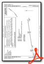
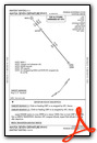
Standard Terminal Arrival (STAR) Charts

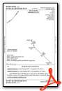
Instrument Approach Procedure (IAP) Charts

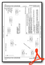
Departure Procedure (DP) Charts

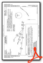
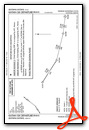
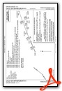
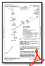
Departure Procedure Obstacles (DPO) Charts

Nearby Airports with Instrument Procedures
| ID | Name | Heading / Distance | ||
|---|---|---|---|---|
 |
KLUF | Luke AFB Airport | 356° | 6.7 |
|
KGEU | Glendale Regional Airport | 032° | 7.4 |
|
KPHX | Phoenix Sky Harbor International Airport | 087° | 18.3 |
|
KDVT | Phoenix Deer Valley Airport | 042° | 21.6 |
|
P19 | Stellar Airpark Airport | 107° | 24.3 |
|
KSDL | Scottsdale Airport | 062° | 26.2 |
|
KCHD | Chandler Municipal Airport | 107° | 29.8 |
|
KFFZ | Falcon Field Airport | 085° | 32.6 |
|
KIWA | Mesa Gateway Airport | 100° | 36.8 |
|
KCGZ | Casa Grande Municipal Airport | 132° | 41.5 |
|
P08 | Coolidge Municipal Airport | 121° | 56.0 |
|
KPAN | Payson Airport | 045° | 71.9 |
Airport Images

By: oatcgyr

By: oatcgyr


