Login
Register


HOE
Homerville Airport
Official FAA Data Effective 2026-02-19 0901Z
Chart Supplement

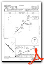
VFR Chart of KHOE
Sectional Charts at SkyVector.com
IFR Chart of KHOE
Enroute Charts at SkyVector.com
Location Information for KHOE
Coordinates: N31°3.41' / W82°46.52'Located 02 miles NW of Homerville, Georgia on 239 acres of land. View all Airports in Georgia.
Surveyed Elevation is 186 feet MSL.
Operations Data
|
|
Airport Communications
| AWOS-3: | 118.725 Tel. 912-487-1253 |
|---|---|
| VALDOSTA APPROACH: | 126.6 ;EAST OF VAD 360-VAD 180 132.375 ;WEST OF VAD R-360 RADIAL 285.6 ;EAST OF VAD 360-VAD 180 |
| VALDOSTA DEPARTURE: | 126.6 ;EAST OF VAD 360-VAD 180 132.375 ;WEST OF VAD R-360 RADIAL 285.6 ;EAST OF VAD 360-VAD 180 |
| IC: | 126.6 ;EAST OF VAD 360-VAD 180 285.6 ;EAST OF VAD 360-VAD 180 |
| CTAF: | 122.900 |
| ATIS at VAD (22.1 W): | 273.5 |
| AWOS-3 at AYS (22.3 NE): | 118.575 912-287-4466 |
| AWOS-3 at DQH (25.6 N): | 119.075 912-383-7258 |
- APCH/DEP SVC PRVDD BY JACKSONVILLE ARTCC ON FREQS 133.7/323.3(VALDOSTA RCAG) WHEN VALDOSTA APCH CTL CLSD.
Nearby Navigation Aids
|
| ||||||||||||||||||||||||||||||||||||||||||||||||||||||||||||


Runway 14/32
| Dimensions: | 4999 x 75 feet / 1524 x 23 meters 75 FT WIDE ASPH OVERLAY; REMAINING 37 1/2 FT WIDTH ON EACH SIDE IS OLD ASPH WITH LOOSE GRAVEL. | |
|---|---|---|
| Surface: | Asphalt in Fair Condition | |
| Weight Limits: | S-30 | |
| Edge Lighting: | Medium Intensity | |
| Runway 14 | Runway 32 | |
| Coordinates: | N31°3.71' / W82°46.85' | N31°3.12' / W82°46.18' |
| Elevation: | 186.7 | 182.4 |
| Traffic Pattern: | Left | Left |
| Runway Heading: | 135° True | 315° True |
| Markings: | Non-Precision Instrument in good condition. | Non-Precision Instrument in good condition. |
| Glide Slope Indicator | P2L (3.00° Glide Path Angle) | P2L (3.00° Glide Path Angle) |
| Obstacles: | 30 ft Trees 320 ft from runway, 267 ft right of center | 43 ft Trees 458 ft from runway, 278 ft left of center |
Services Available
| Fuel: | NONE |
|---|---|
| Transient Storage: | Tiedowns |
| Airframe Repair: | NONE |
| Engine Repair: | NONE |
| Bottled Oxygen: | NONE |
| Bulk Oxygen: | NONE |
| Other Services: | CROP DUSTING SERVICES |
Ownership Information
| Ownership: | Publicly owned | |
|---|---|---|
| Owner: | CITY OF HOMERVILLE | |
| PO BOX 535 | ||
| HOMERVILLE, GA 31634 | ||
| 912-487-2375 | ||
| Manager: | SAMANTHA RITTENHOUSE | |
| PO BOX 535 | ||
| HOMERVILLE, GA 31634 | ||
| 912-487-2375 | ||
Other Remarks
- FOR CD CTC VALDOSTA APCH AT 229-257-2207, WHEN APCH CLSD CTC JACKSONVILLE ARTCC AT 904-845-1592.
- ACTVT PAPI RY 14/32 & MIRL RY 14/32 - CTAF.
Weather Minimums


Instrument Approach Procedure (IAP) Charts


Nearby Airports with Instrument Procedures
| ID | Name | Heading / Distance | ||
|---|---|---|---|---|
 |
KVAD | Moody AFB Airport | 256° | 22.2 |
|
KAYS | Waycross-Ware County Airport | 059° | 22.7 |
|
4J2 | Berrien County Airport | 292° | 25.0 |
|
KDQH | Douglas Municipal Airport | 350° | 25.5 |
|
KVLD | Valdosta Regional Airport | 237° | 30.7 |
|
KAMG | Bacon County Airport | 025° | 31.8 |
|
15J | Cook County Airport | 277° | 35.3 |
|
KTMA | Henry Tift Myers Airport | 301° | 43.0 |
|
KBHC | Baxley Municipal Airport | 026° | 43.9 |
|
4J5 | Quitman Brooks County Airport | 250° | 44.6 |
|
KFZG | Fitzgerald Municipal Airport | 325° | 45.4 |
|
4J1 | Brantley County Airport | 078° | 45.6 |
Airport Images
Do you have a recent image of this airport? Upload it here!


