Login
Register


IJD
Windham Airport
Official FAA Data Effective 2026-01-22 0901Z
Chart Supplement

VFR Chart of KIJD
Sectional Charts at SkyVector.com
IFR Chart of KIJD
Enroute Charts at SkyVector.com
Location Information for KIJD
Coordinates: N41°44.64' / W72°10.81'Located 03 miles NE of Willimantic, Connecticut on 280 acres of land. View all Airports in Connecticut.
Surveyed Elevation is 246 feet MSL.
Operations Data
|
|
Airport Communications
| ASOS: | 133.675 Tel. 860-456-8839 |
|---|---|
| BRADLEY APPROACH: | 127.8 269.325 |
| BRADLEY DEPARTURE: | 127.8 269.325 |
| CLEARANCE DELIVERY: | 128.6 |
| CTAF: | 122.975 |
| UNICOM: | 122.975 |
| AWOS-3 at LZD (13.3 E): | 119.125 860-779-7251 |
| ATIS at HFD (21.0 W): | 126.45 |
| ASOS at HFD (21.1 W): | 860-952-9954 |
- APCH SVC PRVDD BY BOSTON ARTCC ON FREQS 124.85/307.9 (WOODSTOCK RCAG) WHEN PROVIDENCE APCH CTL CLSD.
- NOTE: BRADLEY PRVDS DEP SVC 24 HRS DAILY.
Nearby Navigation Aids
|
| ||||||||||||||||||||||||||||||||||||||||||||||||||||||


Runway 09/27
| Dimensions: | 4271 x 100 feet / 1302 x 30 meters | |
|---|---|---|
| Surface: | Asphalt in Good Condition | |
| Weight Limits: | S-30 | |
| Edge Lighting: | Medium Intensity | |
| Runway 09 | Runway 27 | |
| Coordinates: | N41°44.60' / W72°11.11' | N41°44.79' / W72°10.21' |
| Elevation: | 239.1 | 239.1 |
| Traffic Pattern: | Left | Left |
| Runway Heading: | 74° True | 254° True |
| Displaced Threshold: | 258 Feet | |
| Markings: | Non-Precision Instrument in fair condition. | Non-Precision Instrument in fair condition. |
| REIL: | Yes | |
| Obstacles: | 53 ft Trees 210 ft from runway, 220 ft left of center APCH RATIO 25:1 TO DTHR. |
36 ft Tree 415 ft from runway, 255 ft left of center |
Runway 18/36
| Dimensions: | 2799 x 75 feet / 853 x 23 meters | |
|---|---|---|
| Surface: | Asphalt in Good Condition | |
| Weight Limits: | S-30 | |
| Runway 18 | Runway 36 | |
| Coordinates: | N41°44.78' / W72°11.14' | N41°44.34' / W72°10.96' |
| Elevation: | 234.8 | 245.9 |
| Traffic Pattern: | Left | Left |
| Runway Heading: | 163° True | 343° True |
| Displaced Threshold: | 799 Feet | |
| Markings: | Basic in good condition. | Basic in good condition. |
| Obstacles: | 46 ft Trees 800 ft from runway, 200 ft right of center | 60 ft Trees 800 ft from runway, 50 ft left of center APCH RATIO 20:1 TO DTHR. |
Services Available
| Fuel: | 100LL (blue), Jet A+ |
|---|---|
| Transient Storage: | Tiedowns |
| Airframe Repair: | MAJOR |
| Engine Repair: | MAJOR |
| Bottled Oxygen: | NONE |
| Bulk Oxygen: | NONE |
| Other Services: | PILOT INSTRUCTION |
Ownership Information
| Ownership: | Publicly owned | |
|---|---|---|
| Owner: | CONNECTICUT AIRPORT AUTHORITY | |
| SUITE 160, 334 ELLA GRASSO TURNPIKE | ||
| WINDSOR LOCKS, CT 06096 | ||
| 860-292-2000 | ||
| Manager: | ROBERT PELLIGRINO | |
| CONNECTICUT AIRPORT AUTHORITY, 239 MAXIM RD | ||
| HARTFORD, CT 06114 | ||
| 860-982-2443 | ||
Other Remarks
- 4 OBS LGTS ON SRNDG HILLS OTS INDEFLY.
- BIRDS ON & INVOF ARPT.
- FOR CD CTC BRADLEY APCH AT 860-386-3597.
- GLDR ACT ON & INVOF ARPT APR-NOV.
- LDG FEE FOR BUS/CORPORATE ACFT.
- 0LL SELF SVC FUEL, CREDIT CARD ONLY: VISA, MASTERCARD & DISCOVER.
- SELF SVC FUEL, CREDIT CARD ONLY: VISA, MASTERCARD & DISCOVER. JET A HAS OVR WING & SNGL POINT NOZZLES.
- ACTVT REIL RWY 27; MIRL RWY 09/27- CTAF.
Weather Minimums

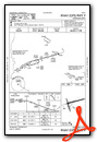
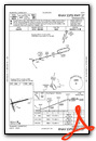
Instrument Approach Procedure (IAP) Charts

Nearby Airports with Instrument Procedures
| ID | Name | Heading / Distance | ||
|---|---|---|---|---|
 |
KHFD | Hartford-Brainard Airport | 268° | 21.1 |
|
3B0 | Southbridge Municipal Airport | 016° | 22.3 |
|
KBDL | Bradley International Airport | 297° | 25.5 |
|
KGON | Groton-New London Airport | 166° | 25.6 |
|
KSNC | Chester Airport | 214° | 26.1 |
|
KWST | Westerly State Airport | 144° | 29.1 |
|
0B8 | Elizabeth Field Airport | 167° | 30.2 |
|
4B8 | Robertson Field Airport | 264° | 30.9 |
|
KCEF | Westover Arb/Metro Airport | 329° | 31.3 |
|
KMMK | Meriden Markham Municipal Airport | 244° | 32.4 |
|
KSFZ | North Central State Airport | 070° | 32.7 |
|
KPVD | Rhode Island Tf Green International Airport | 091° | 33.8 |
Airport Images
Do you have a recent image of this airport? Upload it here!


