Login
Register
ILM
Wilmington International Airport
Official FAA Data Effective 2026-01-22 0901Z
VFR Chart of KILM
Sectional Charts at SkyVector.com
IFR Chart of KILM
Enroute Charts at SkyVector.com
Location Information for KILM
Coordinates: N34°16.27' / W77°54.17'Located 03 miles NE of Wilmington, North Carolina on 1800 acres of land. View all Airports in North Carolina.
Surveyed Elevation is 31 feet MSL.
TPA: 1000 FT AGL RECIPROCATING ENGINE, 1500 FT AGL TBJT/JET. OHD: 5 MILE INITIAL 2500 FT AGL, BREAK 2000 FT AGL. TOWER CALLS DRCTN OF BREAK. CARRIER BREAK NA.
Operations Data
|
|
Airport Communications
| ATIS: | 124.975 |
|---|---|
| ASOS: | Tel. 910-212-6314 |
| WILMINGTON TOWER: | 119.9 239.3 |
| WILMINGTON GROUND: | 121.9 348.6 |
| WILMINGTON APPROACH: | 118.25 ;164-343 135.75 ;344-163 284.65 ;164-343 317.425 ;344-163 |
| WILMINGTON DEPARTURE: | 118.25 ;164-343 135.75 ;344-163 284.65 ;164-343 317.425 ;344-163 |
| CLEARANCE DELIVERY: | 120.875 |
| EMERG: | 121.5 243.0 |
| UNICOM: | 122.950 |
| VFR ADZY: | 119.9 239.3 |
| CTAF: | 119.900 |
| TRSA: | 118.25 ;164-343 135.75 ;344-163 284.65 ;164-343 317.425 ;344-163 |
| AWOS-3P at SUT (22.2 SW): | 124.175 910-457-1710 |
| AWOS-3P at ACZ (27.2 N): | 121.07 910-285-0419 |
| ATIS at NCA (34.9 NE): | 288.325 |
- APCH/DEP SVC PRVDD BY WASHINGTON ARTCC ON FREQS 124.025/269.15 (WILMINGTON RCAG) WHEN WILMINGTON APCH CTL CLSD.
- TWR PH #910-815-4676.
Nearby Navigation Aids
|
| ||||||||||||||||||||||||||||||||||||||||||||||||||||||||||||
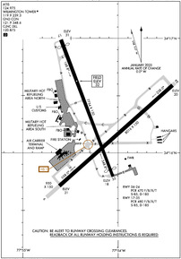
Runway 06/24
BEARING STRENGTH RWY 06-24: ST175 | ||
| Dimensions: | 8016 x 150 feet / 2443 x 46 meters | |
|---|---|---|
| Surface: | Asphalt / Grooved in Good Condition | |
| Weight Limits: | S-85, D-185
PCR VALUE: 470/F/B/X/T
| |
| Edge Lighting: | High Intensity | |
| Runway 06 | Runway 24 | |
| Coordinates: | N34°15.71' / W77°54.62' | N34°16.59' / W77°53.43' |
| Elevation: | 21.0 | 20.2 |
| Traffic Pattern: | Left | Left |
| Runway Heading: | 48° True | 228° True |
| Declared Distances: | TORA:8016 TODA:8016 ASDA:8016 LDA:8016 | TORA:8016 TODA:8016 ASDA:8016 LDA:8016 |
| Markings: | Precision Instrument in good condition. | Precision Instrument in good condition. |
| Glide Slope Indicator | P4R (3.00° Glide Path Angle) | P4L (3.00° Glide Path Angle) |
| RVR Equipment | Touchdown Rollout | Touchdown Rollout |
| Approach Lights: | MALSR 1,400 Foot Medium-intensity Approach Lighting System with runway alignment indicator lights. | |
| REIL: | Yes | |
Runway 17/35
BEARING STRENGTH RWY 17-35: ST175 | ||
| Dimensions: | 7754 x 150 feet / 2363 x 46 meters | |
|---|---|---|
| Surface: | Asphalt / Grooved in Good Condition | |
| Weight Limits: | S-85, D-185
PCR VALUE: 480/F/B/X/T
| |
| Edge Lighting: | High Intensity | |
| Runway 17 | Runway 35 | |
| Coordinates: | N34°16.99' / W77°54.60' | N34°15.79' / W77°54.06' |
| Elevation: | 30.9 | 18.3 |
| Traffic Pattern: | Left | Left |
| Runway Heading: | 159° True | 339° True |
| Displaced Threshold: | 350 Feet | 400 Feet |
| Declared Distances: | TORA:7754 TODA:7754 ASDA:6954 LDA:6604 | TORA:7754 TODA:7754 ASDA:7604 LDA:7204 |
| Markings: | Precision Instrument in good condition. | Precision Instrument in good condition. |
| Glide Slope Indicator | P4L (3.00° Glide Path Angle) | P4L (3.00° Glide Path Angle) |
| RVR Equipment | Rollout | Touchdown |
| Approach Lights: | MALSR 1,400 Foot Medium-intensity Approach Lighting System with runway alignment indicator lights. | |
| REIL: | Yes | |
Services Available
| Fuel: | 100LL (blue), Jet-A, Jet A+ |
|---|---|
| Transient Storage: | Hangars,Tiedowns |
| Airframe Repair: | MAJOR |
| Engine Repair: | MAJOR |
| Bottled Oxygen: | HIGH/LOW |
| Bulk Oxygen: | HIGH/LOW |
| Other Services: | AIR FREIGHT SERVICES,CARGO HANDLING SERVICES,CHARTER SERVICE,PILOT INSTRUCTION,AIRCRAFT RENTAL,AIRCRAFT SALES |
Ownership Information
| Ownership: | Publicly owned | |
|---|---|---|
| Owner: | NEW HANOVER COUNTY | |
| 1740 AIRPORT BLVD | ||
| WILMINGTON, NC 28405 | ||
| 910-341-4333 | ||
| Manager: | JEFFREY BOURK, A.A.E. | |
| 1740 AIRPORT BLVD | ||
| WILMINGTON, NC 28405 | ||
| 910-341-4333 | EXT 1001. | |
Other Remarks
- FUEL: AIR WILMINGTON, INC, 910-763-4691.
- FOR CD IF UNA TO CTC ON FSS FREQ, CTC WASHINGTON ARTCC AT 703-771-3587.
- ACTVT MALSR RWY 24 & 35; REIL RWY 06 & 17; PAPI RWY 06, 17, 24; HIRL RWY 06/24 & 17/35; AND ALL TWY LGTS - CTAF.
- TPA: 1000 FT AGL RECIPROCATING ENGINE, 1500 FT AGL TBJT/JET. OHD: 5 MILE INITIAL 2500 FT AGL, BREAK 2000 FT AGL. TOWER CALLS DRCTN OF BREAK. CARRIER BREAK NA.
Weather Minimums
Instrument Approach Procedure (IAP) Charts
Nearby Airports with Instrument Procedures
| ID | Name | Heading / Distance | ||
|---|---|---|---|---|
 |
KSUT | Cape Fear Regional Jetport/Howie Franklin Field Airport | 202° | 22.1 |
 |
KACZ | Wallace-Pender Airport | 349° | 27.2 |
 |
KNCA | New River MCAS (Mccutcheon Field) Airport | 041° | 34.8 |
 |
KOAJ | Albert J Ellis Airport | 023° | 36.4 |
 |
KEYF | Curtis L Brown Jr Field Airport | 300° | 39.0 |
 |
KCPC | Columbus County Regional Airport | 270° | 40.4 |
 |
KDPL | Duplin County Airport | 354° | 43.8 |
 |
KCTZ | Clinton-Sampson County Airport | 331° | 48.0 |
 |
5J9 | Twin City Airport | 257° | 49.1 |
 |
KCRE | Grand Strand Airport | 236° | 49.3 |
 |
W40 | Mount Olive Municipal Airport | 353° | 57.3 |
 |
KLBT | Lumberton Regional Airport | 289° | 60.9 |


