Login
Register


LBT
Lumberton Regional Airport
Official FAA Data Effective 2026-02-19 0901Z
Chart Supplement

VFR Chart of KLBT
Sectional Charts at SkyVector.com
IFR Chart of KLBT
Enroute Charts at SkyVector.com
Location Information for KLBT
Coordinates: N34°36.59' / W79°3.57'Located 03 miles W of Lumberton, North Carolina on 485 acres of land. View all Airports in North Carolina.
Surveyed Elevation is 124 feet MSL.
Operations Data
|
|
Airport Communications
| ASOS: | 134.775 Tel. 910-739-7120 |
|---|---|
| FAYETTEVILLE APPROACH: | 133.0 290.25 |
| FAYETTEVILLE DEPARTURE: | 133.0 290.25 |
| UNICOM: | 122.800 |
| CTAF: | 122.800 |
| ASOS at MEB (18.7 NW): | 134.125 910-844-5338 |
| AWOS-3P at EYF (23.6 E): | 119.475 910-862-9982 |
| ASOS at FAY (24.5 N): | 121.25 910-484-1546 |
Nearby Navigation Aids
|
| ||||||||||||||||||||||||||||||||||||||||||||||||||||||||||||


Runway 05/23
| Dimensions: | 5505 x 150 feet / 1678 x 46 meters | |
|---|---|---|
| Surface: | Asphalt in Excellent Condition | |
| Weight Limits: | 22 /F/C/X/T, S-15, D-80 | |
| Edge Lighting: | Medium Intensity | |
| Runway 05 | Runway 23 | |
| Coordinates: | N34°36.26' / W79°4.04' | N34°36.90' / W79°3.26' |
| Elevation: | 123.2 | 123.1 |
| Traffic Pattern: | Left | Left |
| Runway Heading: | 45° True | 225° True |
| Displaced Threshold: | 162 Feet | |
| Markings: | Precision Instrument in good condition. | Precision Instrument in good condition. |
| Glide Slope Indicator | P4L (3.00° Glide Path Angle) | P2L (3.20° Glide Path Angle) |
| REIL: | Yes | Yes |
| Obstacles: | 78 ft Trees 2140 ft from runway, 506 ft right of center APCH RATIO 26:1 AT DSPLCD THR. |
44 ft Trees 630 ft from runway, 178 ft left of center 56 FT TREES 0-200 FT FM THR OFFSET 233 FT LEFT. |
Runway 13/31
| Dimensions: | 5007 x 75 feet / 1526 x 23 meters | |
|---|---|---|
| Surface: | Asphalt in Excellent Condition | |
| Weight Limits: | S-8 | |
| Runway 13 | Runway 31 | |
| Coordinates: | N34°36.84' / W79°3.90' | N34°36.37' / W79°3.08' |
| Elevation: | 123.8 | 121.3 |
| Traffic Pattern: | Left | Left |
| Runway Heading: | 125° True | 305° True |
| Displaced Threshold: | 590 Feet | |
| Markings: | Non-Precision Instrument in good condition. | Non-Precision Instrument in good condition. |
| Obstacles: | 38 ft Trees 468 ft from runway, 155 ft left of center 9 FT FENCE 100 FT TO 200 FT FM THR OFFSET 240 FT L AND R OF CNTRLN. |
29 ft Trees 297 ft from runway, 7 ft right of center APCH RATIO 21:1 AT DSPLCD THR. 15 FT ROAD 170 FT FM THR BOTH SIDES AND 10 FT FENCE 154 FT FM THR BOTH SIDES. |
Services Available
| Fuel: | 100LL (blue), Jet A-1+, Automotive Gasoline |
|---|---|
| Transient Storage: | Hangars,Tiedowns |
| Airframe Repair: | MAJOR |
| Engine Repair: | MAJOR |
| Bottled Oxygen: | NONE |
| Bulk Oxygen: | NONE |
| Other Services: | CHARTER SERVICE,PILOT INSTRUCTION,AIRCRAFT RENTAL,AIRCRAFT SALES |
Ownership Information
| Ownership: | Publicly owned | |
|---|---|---|
| Owner: | CITY OF LUMBERTON | |
| P. O. BOX 1388 | ||
| LUMBERTON, NC 28359 | ||
| 910-671-3800 | ||
| Manager: | GARY LEWIS | |
| 163 AIRPORT BLVD | ||
| LUMBERTON, NC 28358 | ||
| 910-739-6480 | ||
Other Remarks
- RWYS 05/23 & 13/31 NO LN OF SIGHT BTN RWY ENDS.
- DEER & BIRDS ON & INVOF ARPT.
- FARMING OPS NEAR RWYS AND TWYS.
- FOR CD CTC WASHINGTON ARTCC AT 703-771-3587.
- 0LL 100LL FUEL 24 HR CREDIT CARD SVC AVBL.
- + PPR FOR JET A FUEL AFTER HRS, CALL AMGR 910-608-1219.
- ACTVT REIL RWY 05 & 23; PAPI RWY 05 & 23; MIRL RWY 05/23 - CTAF.
Weather Minimums

Instrument Approach Procedure (IAP) Charts


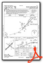
Nearby Airports with Instrument Procedures
| ID | Name | Heading / Distance | ||
|---|---|---|---|---|
 |
KDLC | Dillon County Airport | 237° | 18.1 |
|
KMEB | Laurinburg/Maxton Airport | 305° | 18.7 |
|
KEYF | Curtis L Brown Jr Field Airport | 091° | 23.8 |
|
KFAY | Fayetteville Regional/Grannis Field Airport | 021° | 24.5 |
|
5W4 | P K Airpark Airport | 345° | 25.4 |
|
KCPC | Columbus County Regional Airport | 139° | 26.5 |
|
KMAO | Marion County Airport | 208° | 29.1 |
|
5J9 | Twin City Airport | 162° | 32.7 |
|
KBBP | Marlboro County Jetport/H E Avent Field Airport | 271° | 33.4 |
|
KPOB | Pope AAF Airport | 003° | 33.7 |
|
KRCZ | Richmond County Airport | 296° | 38.5 |
|
KCTZ | Clinton-Sampson County Airport | 057° | 40.7 |
Airport Images
Do you have a recent image of this airport? Upload it here!


Comments
EXCELLENT AIRPORT WITH GREAT
EXCELLENT AIRPORT WITH GREAT FUEL PRICES. NON-TOWERED HOWEVER THERE IS USUALLY AN AIRPORT ADVISOR TO HELP OUT DURING NORMAL OPERATING HOURS. CREW CAR AVAILABLE WITH RESTAURANTS ABOUT A MILE AWAY.
BERNIE