Login
Register
ORH
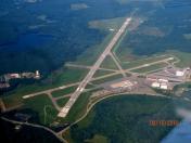
Worcester Regional Airport
Official FAA Data Effective 2026-01-22 0901Z
VFR Chart of KORH
Sectional Charts at SkyVector.com
IFR Chart of KORH
Enroute Charts at SkyVector.com
Location Information for KORH
Coordinates: N42°16.03' / W71°52.54'Located 03 miles W of Worcester, Massachusetts on 1000 acres of land. View all Airports in Massachusetts.
Surveyed Elevation is 1009 feet MSL.
Operations Data
|
|
Airport Communications
| ATIS: | 126.55 (508-757-0962) |
|---|---|
| ASOS: | Tel. 508-767-5851 |
| WORCESTER TOWER: | 120.5 263.0 |
| WORCESTER GROUND: | 123.85 |
| BRADLEY APPROACH: | 119.0 327.1 |
| BRADLEY DEPARTURE: | 119.0 327.1 |
| CLEARANCE DELIVERY: | 128.65 119.0 ;WHEN TWR CLSD |
| CTAF: | 120.500 |
| UNICOM: | 122.950 |
| STELA STAR: | 125.35 281.5 |
| EMERG: | 121.5 243.0 |
| ASOS at FIT (18.1 N): | 135.175 978-343-9121 |
| ASOS at ORE (25.8 NW): | 135.675 978-544-6774 |
| AWOS-3 at LZD (26.9 S): | 119.125 860-779-7251 |
Nearby Navigation Aids
|
| ||||||||||||||||||||||||||||||||||||||||||||||||||||||||||||
Runway 11/29
| Dimensions: | 7001 x 150 feet / 2134 x 46 meters | |
|---|---|---|
| Surface: | Asphalt / Grooved in Excellent Condition | |
| Weight Limits: | S-120, D-250, ST-550
PCR VALUE: 1400/F/D/W/T
| |
| Edge Lighting: | High Intensity | |
| Runway 11 | Runway 29 | |
| Coordinates: | N42°16.04' / W71°53.45' | N42°15.96' / W71°51.90' |
| Elevation: | 980.0 | 987.9 |
| Traffic Pattern: | Left | Left |
| Runway Heading: | 94° True | 274° True |
| Declared Distances: | TORA:7001 TODA:7001 ASDA:7001 LDA:7001 | TORA:7001 TODA:7001 ASDA:7001 LDA:7001 |
| Markings: | Precision Instrument in good condition. | Precision Instrument in good condition. |
| Glide Slope Indicator | P4R (3.00° Glide Path Angle) | P4L (3.00° Glide Path Angle) |
| RVR Equipment | Touchdown Midfield Rollout | Touchdown Midfield Rollout |
| Approach Lights: | ALSF2 Standard 2,400 Foot High-intensity Approach Lighting System with sequenced flashers, CATEGORY II or III Configuration. RWY 11 ALSF-2 BECOMES SSALS PRESET ON MED INTST ONLY WHEN TWR CLSD. | |
| REIL: | Yes | |
| Centerline Lights: | Yes | Yes |
| Obstacles: | 110 ft Hill 4500 ft from runway | |
Runway 15/33
| Dimensions: | 5000 x 100 feet / 1524 x 30 meters | |
|---|---|---|
| Surface: | Asphalt / Grooved in Good Condition | |
| Weight Limits: | S-85, D-120, ST-210
PCR VALUE: 470/F/D/W/T
| |
| Edge Lighting: | Medium Intensity | |
| Runway 15 | Runway 33 | |
| Coordinates: | N42°16.37' / W71°52.72' | N42°15.76' / W71°51.97' |
| Elevation: | 1008.9 | 997.9 |
| Traffic Pattern: | Left | Left |
| Runway Heading: | 138° True | 318° True |
| Declared Distances: | TORA:5000 TODA:5000 ASDA:5000 LDA:5000 | TORA:5000 TODA:5000 ASDA:5000 LDA:5000 |
| Markings: | Basic in good condition. | Non-Precision Instrument in good condition. |
| Glide Slope Indicator | V4L (3.60° Glide Path Angle) RWY 15 VASI UNUSBL BYD 9 DEG L OF CRS. | P4L (3.00° Glide Path Angle) |
| REIL: | Yes | Yes |
| Obstacles: | 252 ft Antenna 14000 ft from runway, 10 ft left of center | |
Services Available
| Fuel: | 100LL (blue), Jet-A |
|---|---|
| Transient Storage: | Hangars,Tiedowns |
| Airframe Repair: | MAJOR |
| Engine Repair: | MAJOR |
| Bottled Oxygen: | NONE |
| Bulk Oxygen: | NOT AVAILABLE |
| Other Services: | AVIONICS,CARGO HANDLING SERVICES,CHARTER SERVICE,PILOT INSTRUCTION,AIRCRAFT RENTAL |
Ownership Information
| Ownership: | Publicly owned | |
|---|---|---|
| Owner: | MASS PORT AUTHORITY | |
| 375 AIRPORT DR | ||
| WORCESTER, MA 01602 | ||
| 508-849-5550 | ||
| Manager: | ANDREW B DAVIS | |
| WORCESTER REGIONAL AIRPORT, 5 AIRPORT DR | ||
| WORCESTER, MA 01602 | ||
| 508-849-5550 | ||
Other Remarks
- WILDLIFE & BIRDS ON & INVOF ARPT.
- USE CTN FOR ARPT VEHICLES MNT CTAF & OPERG ON ARPT DURG NON-TWR HRS.
- TSNT ACFT CTC FBO ON 122.95 FOR SVCS.
- RWY GUARD LGTS INSTLD ON ALL TWY TO RWY INTXNS, RWY 11/29 ONLY.
- WHEN ATCT CLSD, FOR CD CTC BRADLEY APCH 860-386-3597.
- ACTVT REIL RWY 15, 29 & 33; HIRL RWY 11/29; MIRL RWY 15/33 - CTAF.
- ENGRD MTRLS ARST SYS 170 FT WID, 154 FT LEN, LCTD AT DER 11.
- ENGRD MTRLS ARST SYS 170 FT WID, 300 FT LEN, LCTD AT DER 29.
Weather Minimums
Standard Terminal Arrival (STAR) Charts
Instrument Approach Procedure (IAP) Charts
Nearby Airports with Instrument Procedures
| ID | Name | Heading / Distance | ||
|---|---|---|---|---|
 |
3B0 | Southbridge Municipal Airport | 216° | 12.3 |
 |
KFIT | Fitchburg Municipal Airport | 016° | 18.0 |
 |
KGDM | Gardner Municipal Airport | 339° | 18.1 |
 |
1B6 | Hopedale Industrial Park Airport | 120° | 18.9 |
 |
6B6 | Minute Man Air Field Airport | 053° | 19.7 |
 |
KORE | Orange Municipal Airport | 314° | 25.8 |
 |
KSFZ | North Central State Airport | 140° | 26.9 |
 |
KBED | Laurence G Hanscom Field Airport | 064° | 28.8 |
 |
KCEF | Westover Arb/Metro Airport | 261° | 29.7 |
 |
KOWD | Norwood Memorial Airport | 098° | 31.7 |
 |
KAFN | Jaffrey Airfield Silver Ranch Airport | 350° | 32.8 |
 |
7B2 | Northampton Airport | 276° | 33.0 |


