Login
Register


UBX
Cuba Municipal Airport
Official FAA Data Effective 2025-12-25 0901Z
Chart Supplement

VFR Chart of KUBX
Sectional Charts at SkyVector.com
IFR Chart of KUBX
Enroute Charts at SkyVector.com
Location Information for KUBX
Coordinates: N38°4.13' / W91°25.73'Located 01 miles NW of Cuba, Missouri on 105 acres of land. View all Airports in Missouri.
Surveyed Elevation is 1023 feet MSL.
Operations Data
|
|
Airport Communications
| CTAF: | 122.800 |
|---|---|
| UNICOM: | 122.800 |
| AWOS-3PT at UUV (16.1 NE): | 119.375 573-860-2596 |
| ASOS at VIH (16.5 W): | 119.025 573-299-4419 |
| AWOS-3PT at FYG (37.3 NE): | 121.325 636-433-5914 |
- APCH/DEP SVC PRVDD BY KANSAS CITY ARTCC ON FREQS 128.35/284.675 (MAPLES RCAG).
Nearby Navigation Aids
|
| ||||||||||||||||||||||||||||||||||||||||||||||||||||||||||||


Runway 01/19
| Dimensions: | 3420 x 61 feet / 1042 x 19 meters | |
|---|---|---|
| Surface: | Asphalt in Fair Condition | |
| Weight Limits: | S-12 | |
| Edge Lighting: | Medium Intensity | |
| Runway 01 | Runway 19 | |
| Coordinates: | N38°3.85' / W91°25.77' | N38°4.41' / W91°25.70' |
| Elevation: | 1019.4 | 1023.0 |
| Traffic Pattern: | Left | Left |
| Runway Heading: | 6° True | 186° True |
| Markings: | Non-Precision Instrument in fair condition. | Non-Precision Instrument in fair condition. |
| Glide Slope Indicator | P2L (3.25° Glide Path Angle) | P2L (3.00° Glide Path Angle) |
| REIL: | Yes | Yes |
Services Available
| Fuel: | 100LL (blue) |
|---|---|
| Transient Storage: | Hangars,Tiedowns |
| Airframe Repair: | MAJOR |
| Engine Repair: | MAJOR |
| Bottled Oxygen: | NONE |
| Bulk Oxygen: | NONE |
| Other Services: | PILOT INSTRUCTION,AIRCRAFT RENTAL |
Ownership Information
| Ownership: | Publicly owned | |
|---|---|---|
| Owner: | CITY OF CUBA | |
| 202 N SMITH ST., PO BOX K | ||
| CUBA, MO 65453 | ||
| 573-885-7432 | ||
| Manager: | TRAVIS PRITCHETT | |
| 1312 HWY DD | ||
| CUBA, MO 65453 | ||
| 573-885-2479 | AFTER HOURS PHONE 573-578-5188 | |
Other Remarks
- FOR CD CTC KANSAS CITY ARTCC AT 913-254-8508.
- 0LL SELF SERVICE FUEL AVBL 24 HRS A DAY
- ACTVT REIL RWY 01 & 19; PAPI RWY 01 & 19; MIRL RWY 01/19 - CTAF.
- UNICOM UNMON.
Weather Minimums
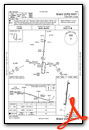
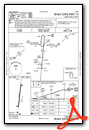
Instrument Approach Procedure (IAP) Charts
Nearby Airports with Instrument Procedures
| ID | Name | Heading / Distance | ||
|---|---|---|---|---|
 |
KUUV | Sullivan Regional Airport | 051° | 15.9 |
|
KVIH | Rolla Ntl Airport | 282° | 16.5 |
|
K33 | Salem Memorial Airport | 197° | 28.4 |
|
8WC | Washington County Airport | 103° | 34.1 |
|
KFYG | Washington Regional Airport | 033° | 37.3 |
|
KTBN | Waynesville-St Robert Regional Forney Field Airport | 240° | 39.1 |
|
KJEF | Jefferson City Memorial Airport | 312° | 46.5 |
|
KFAM | Farmington Regional Airport | 110° | 50.9 |
|
KSUS | Spirit of St Louis Airport | 045° | 51.1 |
|
M48 | Houston Memorial Airport | 210° | 51.3 |
|
KAIZ | Lee C Fine Memorial Airport | 272° | 53.1 |
|
KFTT | Elton Hensley Memorial Airport | 329° | 53.5 |
Airport Images
Do you have a recent image of this airport? Upload it here!


Comments
Great Stop!
Recently stopped here on a long cross-country for an after hours fuel stop. Great little airport with 24-hour restrooms and a nice little pilot lounge. Fuel pumps were easily accessible and had good fuel prices. Thank you City of Cuba!
Paul Pillar
PA-28-180: N4375T
Senior Flight Test Engineer/Test Conductor
FAA Safety Team (FAAST) Representative
Civil Air Patrol Oklahoma Wing Director of Aerospace Education (DAE)