Login
Register


AIZ
Lee C Fine Memorial Airport
Official FAA Data Effective 2026-02-19 0901Z
Chart Supplement

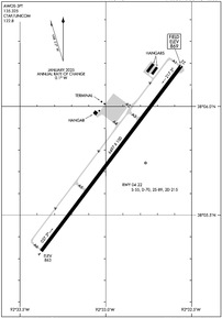
KAIZ Airport Diagram
VFR Chart of KAIZ
Sectional Charts at SkyVector.com
IFR Chart of KAIZ
Enroute Charts at SkyVector.com
Location Information for KAIZ
Coordinates: N38°5.76' / W92°32.97'Located 03 miles SE of Kaiser/Lake Ozark, Missouri on 215 acres of land. View all Airports in Missouri.
Surveyed Elevation is 868 feet MSL.
Operations Data
|
|
Airport Communications
| AWOS-3PT: | 135.325 Tel. 573-348-0847 |
|---|---|
| MIZZU APPROACH: | 124.1 353.925 |
| MIZZU DEPARTURE: | 124.1 353.925 |
| UNICOM: | 122.800 |
| CTAF: | 122.800 |
| AWOS-3PT at OZS (9.9 SW): | 120.225 573-233-1004 |
| AWOS-3PT at LBO (27.5 S): | 118.975 417-533-3419 |
| ASOS at TBN (28.5 SE): | 118.7 |
Nearby Navigation Aids
|
| ||||||||||||||||||||||||||||||||||||||||||||||||


Runway 04/22
| Dimensions: | 6497 x 100 feet / 1980 x 30 meters | |
|---|---|---|
| Surface: | Asphalt / Aggregate Friction Seal Coated in Good Condition | |
| Weight Limits: | S-55, D-70, ST-215 | |
| Edge Lighting: | Medium Intensity | |
| Runway 04 | Runway 22 | |
| Coordinates: | N38°5.33' / W92°33.38' | N38°6.19' / W92°32.56' |
| Elevation: | 862.8 | 868.8 |
| Traffic Pattern: | Left | Left |
| Runway Heading: | 37° True | 217° True |
| Markings: | Non-Precision Instrument in fair condition. | Non-Precision Instrument in fair condition. |
| Glide Slope Indicator | V4L (3.00° Glide Path Angle) | V4L (3.00° Glide Path Angle) |
Services Available
| Fuel: | 100LL (blue), Jet-A |
|---|---|
| Transient Storage: | Tiedowns |
| Airframe Repair: | NOT AVAILABLE |
| Engine Repair: | NOT AVAILABLE |
| Bottled Oxygen: | NOT AVAILABLE |
| Bulk Oxygen: | NOT AVAILABLE |
| Other Services: | CHARTER SERVICE |
Ownership Information
| Ownership: | Publicly owned | |
|---|---|---|
| Owner: | CITY OF OSAGE BEACH | |
| 1000 CITY PARKWAY | ||
| OSAGE BEACH, MO 65065 | ||
| 573-302-2000 | ||
| Manager: | TY DINSDALE | |
| 1000 CITY PARKWAY-CITY HALL | ||
| OSAGE BEACH, MO 65065 | ||
| 573-348-5251 | ARPT PHONE 573-348-5251. | |
Other Remarks
- BIRDS ON & INVOF ARPT; ARPT IN STATE PARK.
- RWY 22 TARND LTD TO ACFT WEIGHING ONLY 12500 LBS OR LESS.
- DISTANCE REMAINING MARKERS ON SE SIDE OF RY 04/22.
- FOR CD CTC MIZZOU APCH AT 417-868-5620/5619.
- ACTVT VASI RWY 04 & 22 - CTAF. MIRLS ARE ON PHOTOCELL.
Weather Minimums


Instrument Approach Procedure (IAP) Charts


Nearby Airports with Instrument Procedures
| ID | Name | Heading / Distance | ||
|---|---|---|---|---|
 |
K15 | Grand Glaize-Osage Beach Airport | 277° | 6.3 |
|
KOZS | Camdenton Memorial-Lake Regional Airport | 222° | 10.0 |
|
H79 | Eldon Model Airpark Airport | 356° | 15.9 |
|
KLBO | Floyd W Jones Lebanon Airport | 190° | 27.3 |
|
KTBN | Waynesville-St Robert Regional Forney Field Airport | 137° | 28.8 |
|
KJEF | Jefferson City Memorial Airport | 031° | 35.0 |
|
KVIH | Rolla Ntl Airport | 086° | 37.0 |
|
KRAW | Warsaw Municipal Airport | 292° | 40.5 |
|
KCOU | Columbia Regional Airport | 019° | 46.0 |
|
KDMO | Sedalia Regional Airport | 321° | 47.1 |
|
M17 | Bolivar Municipal Airport | 231° | 48.3 |
|
KFTT | Elton Hensley Memorial Airport | 029° | 51.4 |
Airport Images
Do you have a recent image of this airport? Upload it here!


