Login
Register


LRU
Las Cruces International Airport
Official FAA Data Effective 2026-02-19 0901Z
Chart Supplement

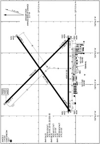
KLRU Airport Diagram
VFR Chart of KLRU
Sectional Charts at SkyVector.com
IFR Chart of KLRU
Enroute Charts at SkyVector.com
Location Information for KLRU
Coordinates: N32°17.36' / W106°55.32'Located 08 miles W of Las Cruces, New Mexico on 2193 acres of land. View all Airports in New Mexico.
Surveyed Elevation is 4456 feet MSL.
Operations Data
|
|
Airport Communications
| AWOS-3: | 119.025 Tel. 575-526-4831 |
|---|---|
| UNICOM: | 122.700 |
| CTAF: | 122.700 |
| AWOS-3PT at DNA (27.4 SE): | 124.175 575-589-2643 |
| ASOS at ELP (39.5 SE): | 915-774-9497 |
| D-ATIS at ELP (40.1 SE): | 120.0 |
- APCH/DEP SVC PRVDD BY ALBUQUERQUE ARTCC (ABQ) ON FREQS 128.2/285.5 (EL PASO/B/ RCAG).
Nearby Navigation Aids
|
| ||||||||||||||||||||||||||||||||||||


Runway 12/30
RWY 30 CALM WIND RWY. | ||
| Dimensions: | 7506 x 100 feet / 2288 x 30 meters | |
|---|---|---|
| Surface: | Concrete / Grooved in Good Condition | |
| Weight Limits: | S-70, D-120
PCR VALUE: 520/R/B/W/T
| |
| Edge Lighting: | High Intensity | |
| Runway 12 | Runway 30 | |
| Coordinates: | N32°17.95' / W106°55.80' | N32°17.08' / W106°54.77' |
| Elevation: | 4456.9 | 4436.0 |
| Traffic Pattern: | Left | Left |
| Runway Heading: | 135° True | 315° True |
| Declared Distances: | TORA:7506 TODA:7506 ASDA:7506 LDA:7506 | TORA:7506 TODA:7506 ASDA:7500 LDA:7500 |
| Markings: | Non-Precision Instrument in good condition. | Precision Instrument in good condition. |
| Approach Lights: | MALSR 1,400 Foot Medium-intensity Approach Lighting System with runway alignment indicator lights. | |
| REIL: | Yes | |
Runway 04/22
ACR & ACFT OVER 30000 LBS NA. | ||
| Dimensions: | 7501 x 105 feet / 2286 x 32 meters | |
|---|---|---|
| Surface: | Asphalt in Poor Condition BLOCK CRACKING UP TO 3 IN WIDE CRACKS, RAVELING, AND WEATHERING. | |
| Weight Limits: | S-30, D-30, ST-30, DT-30
PCR VALUE: 90/F/D/X/T
| |
| Edge Lighting: | Medium Intensity | |
| Runway 04 | Runway 22 | |
| Coordinates: | N32°17.07' / W106°55.93' | N32°17.79' / W106°54.74' |
| Elevation: | 4436.0 | 4451.8 |
| Traffic Pattern: | Left | Left |
| Runway Heading: | 55° True | 235° True |
| Declared Distances: | TORA:7499 TODA:7499 ASDA:7499 LDA:7499 | TORA:7499 TODA:7499 ASDA:7499 LDA:7499 |
| Markings: | Basic in fair condition. | Basic in fair condition. |
| Glide Slope Indicator | V4L (3.00° Glide Path Angle) | |
Runway 08/26
| Dimensions: | 6069 x 100 feet / 1850 x 30 meters | |
|---|---|---|
| Surface: | Asphalt in Fair Condition | |
| Weight Limits: | S-70, D-120
PCR VALUE: 240/F/C/X/T
| |
| Edge Lighting: | Medium Intensity | |
| Runway 08 | Runway 26 | |
| Coordinates: | N32°17.10' / W106°55.93' | N32°17.10' / W106°54.76' |
| Elevation: | 4436.6 | 4435.9 |
| Traffic Pattern: | Left | Left |
| Runway Heading: | 90° True | 270° True |
| Declared Distances: | TORA:6069 TODA:6069 ASDA:6050 LDA:6050 | TORA:6069 TODA:6069 ASDA:6069 LDA:6069 |
| Markings: | Basic in good condition. | Basic in fair condition. |
| Glide Slope Indicator | P4L (3.00° Glide Path Angle) | P4L (3.00° Glide Path Angle) |
Services Available
| Fuel: | 100LL (blue), Jet A-1+ |
|---|---|
| Transient Storage: | Hangars,Tiedowns |
| Airframe Repair: | MAJOR |
| Engine Repair: | MAJOR |
| Bottled Oxygen: | HIGH |
| Bulk Oxygen: | HIGH |
| Other Services: | AIR FREIGHT SERVICES,AIR AMBULANCE SERVICES,PILOT INSTRUCTION,AIRCRAFT RENTAL |
Ownership Information
| Ownership: | Publicly owned | |
|---|---|---|
| Owner: | CITY OF LAS CRUCES | |
| PO BOX 20000 | ||
| LAS CRUCES, NM 88004 | ||
| (575) 541-2471 | ||
| Manager: | ANDY HUME | |
| PO BOX 20000 | ||
| LAS CRUCES, NM 88004 | ||
| (575) 541-2473 | ||
Other Remarks
- BIRDS ON & INVOF ARPT SEP-MAR. UAS TRNG ON ARPT.
- UAS TRNG & FOR CD CTC ALBUQUERQUE ARTCC AT 505-856-4861.
- ACTVT MALSR RWY 30; MIRL RWY 04/22 & 8/26; HIRL RWY 12/30 - CTAF. REIL RWY 12 SS-SR. PAPI RWY 08, 26 & VASI RWY 22 ON CONSLY. MIRL RWY 08/26 PRESET LOW INTST; INCR INTST - CTAF.
Weather Minimums
Instrument Approach Procedure (IAP) Charts

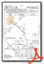

Nearby Airports with Instrument Procedures
| ID | Name | Heading / Distance | ||
|---|---|---|---|---|
 |
KDNA | Dona Ana County International Jetport Airport | 155° | 26.9 |
|
KELP | El Paso International Airport | 135° | 40.1 |
|
KDMN | Deming Municipal Airport | 267° | 40.6 |
|
KHMN | Holloman AFB Airport | 050° | 53.2 |
|
KALM | Alamogordo-White Sands Regional Airport | 054° | 57.6 |
|
KTCS | Truth Or Consequences Municipal Airport | 342° | 59.3 |
|
KSVC | Grant County Airport | 288° | 66.0 |
|
KSRR | Sierra Blanca Regional Airport | 044° | 99.3 |
|
KONM | Socorro Municipal Airport | 000° | 103.8 |
|
KCFT | Greenlee County Airport | 289° | 122.7 |
|
KATS | Artesia Municipal Airport | 074° | 128.9 |
|
KVHN | Culberson County Airport | 123° | 132.0 |
Fuel Providers

US Dollar per US Gallon
Price Guaranteed by FBO

Airport Images
Do you have a recent image of this airport? Upload it here!


