Login
Register


ATS
Artesia Municipal Airport
Official FAA Data Effective 2026-02-19 0901Z
Chart Supplement

VFR Chart of KATS
Sectional Charts at SkyVector.com
IFR Chart of KATS
Enroute Charts at SkyVector.com
Location Information for KATS
Coordinates: N32°51.12' / W104°28.05'Located 03 miles W of Artesia, New Mexico on 1440 acres of land. View all Airports in New Mexico.
Surveyed Elevation is 3544 feet MSL.
Operations Data
|
|
Airport Communications
| AWOS-3: | 126.725 Tel. 575-748-0270 |
|---|---|
| ROSWELL APPROACH: | 119.6 239.0 |
| ROSWELL DEPARTURE: | 119.6 239.0 |
| UNICOM: | 123.075 |
| CTAF: | 123.075 |
| ATIS at ROW (27.1 N): | 128.45 |
| ASOS at ROW (27.4 N): | 128.45 575-286-1096 |
| ASOS at CNM (32.6 S): | 118.375 575-887-6858 |
- APCH/DEP SVC PRVDD BY ALBUQUERQUE ARTCC ON FREQS 132.65/257.6 (ROSWELL RCAG) WHEN ROSWELL APCH CTL CLSD.
Nearby Navigation Aids
|
| ||||||||||||||||||||||||||||||||||||||||||||||||||||||


Runway 04/22
| Dimensions: | 6800 x 150 feet / 2073 x 46 meters | |
|---|---|---|
| Surface: | Asphalt / Porous Friction Course in Good Condition | |
| Weight Limits: | 17 /F/C/Y/T, S-40, D-57 | |
| Edge Lighting: | Medium Intensity | |
| Runway 04 | Runway 22 | |
| Coordinates: | N32°50.70' / W104°28.57' | N32°51.50' / W104°27.63' |
| Elevation: | 3544.5 | 3519.5 |
| Traffic Pattern: | Left | Left |
| Runway Heading: | 45° True | 225° True |
| Displaced Threshold: | 499 Feet | |
| Markings: | Basic in good condition. | Non-Precision Instrument in good condition. |
| Glide Slope Indicator | P4R (3.00° Glide Path Angle) | P4L (3.00° Glide Path Angle) |
Runway 13/31
| Dimensions: | 6132 x 100 feet / 1869 x 30 meters | |
|---|---|---|
| Surface: | Asphalt / Porous Friction Course in Good Condition | |
| Weight Limits: | 17 /F/C/Y/T, S-40, D-57 | |
| Edge Lighting: | Medium Intensity | |
| Runway 13 | Runway 31 | |
| Coordinates: | N32°51.49' / W104°28.42' | N32°50.78' / W104°27.58' |
| Elevation: | 3533.5 | 3506.3 |
| Traffic Pattern: | Left | Left |
| Runway Heading: | 135° True | 315° True |
| Markings: | Non-Precision Instrument in good condition. | Non-Precision Instrument in good condition. |
| Glide Slope Indicator | P4L (3.00° Glide Path Angle) | P4L (3.00° Glide Path Angle) |
Services Available
| Fuel: | 100LL (blue), Jet A-1 |
|---|---|
| Transient Storage: | Hangars,Tiedowns CALL AHEAD - AMGR. |
| Airframe Repair: | NOT AVAILABLE |
| Engine Repair: | NOT AVAILABLE |
| Bottled Oxygen: | NOT AVAILABLE |
| Bulk Oxygen: | NOT AVAILABLE |
Ownership Information
| Ownership: | Publicly owned | |
|---|---|---|
| Owner: | CITY OF ARTESIA | |
| 702 AIRPORT RD | ||
| ARTESIA, NM 88210 | ||
| 575-746-2122 | ||
| Manager: | LANCE GOODRICH | |
| PO BOX 1310 | ||
| ARTESIA, NM 88211 | ||
| 575-748-3206 | ||
Other Remarks
- FOR CD CTC ALBUQUERQUE ARTCC AT 505-856-4861.
- AFT HR FUEL & EMERG REPAIR - AMGR.
- ACTVT PAPI RWY 04, 13, 22 & 31; MIRL RWY 04/22 & 13/31 - CTAF.
Weather Minimums
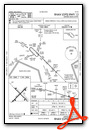
Instrument Approach Procedure (IAP) Charts


Nearby Airports with Instrument Procedures
| ID | Name | Heading / Distance | ||
|---|---|---|---|---|
 |
KROW | Roswell Air Center Airport | 353° | 27.0 |
|
KCNM | Cavern City Air Trml Airport | 161° | 32.5 |
|
E06 | Lea County/Zip Franklin Memorial Airport | 083° | 53.8 |
|
KHOB | Lea County Regional Airport | 098° | 64.0 |
|
KSRR | Sierra Blanca Regional Airport | 304° | 64.8 |
|
KALM | Alamogordo-White Sands Regional Airport | 269° | 77.0 |
|
KHMN | Holloman AFB Airport | 270° | 82.9 |
|
F98 | Yoakum County Airport | 074° | 85.4 |
|
KINK | Winkler County Airport | 134° | 90.9 |
|
KGNC | Gaines County Airport | 096° | 92.4 |
|
KPRZ | Portales Municipal Airport | 034° | 93.9 |
|
KPEQ | Pecos Municipal Airport | 150° | 100.6 |
Airport Images
Do you have a recent image of this airport? Upload it here!


