Login
Register


MD1
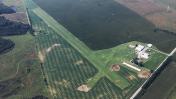
Massey Aerodrome Airport
Official FAA Data Effective 2026-01-22 0901Z
Chart Supplement

VFR Chart of MD1
Sectional Charts at SkyVector.com
IFR Chart of MD1
Enroute Charts at SkyVector.com
Location Information for MD1
Coordinates: N39°17.96' / W75°47.96'Located 02 miles E of Massey, Maryland on 93 acres of land. View all Airports in Maryland.
Estimated Elevation is 73 feet MSL.
Operations Data
|
|
Airport Communications
| CTAF: | 122.900 |
|---|---|
| AWOS-3 at 33N (10.5 SE): | 120.125 302-571-6012 |
| AWOS-3 at EVY (13.8 N): | 132.325 302-378-2063 |
| D-ATIS at DOV (18.6 SE): | 127.825 |
Nearby Navigation Aids
|
| ||||||||||||||||||||||||||||||||||||||||||||||||||||||||||||


Runway 02/20
| Dimensions: | 3000 x 100 feet / 914 x 30 meters | |
|---|---|---|
| Surface: | Turf in Good Condition | |
| Runway 02 | Runway 20 | |
| Coordinates: | N39°17.72' / W75°48.04' | N39°18.20' / W75°47.88' |
| Displaced Threshold: | 120 Feet | |
| Markings: | Numbers Only in good condition. | Numbers Only in good condition. |
| Obstacles: | 55 ft Power Line 928 ft from runway, 64 ft left of center APCH RATIO 20:1 TO DSPLCD THLR. |
|
Services Available
| Fuel: | NONE |
|---|---|
| Transient Storage: | Tiedowns |
| Airframe Repair: | NOT AVAILABLE |
| Engine Repair: | NOT AVAILABLE |
| Bottled Oxygen: | NOT AVAILABLE |
| Bulk Oxygen: | NOT AVAILABLE |
Ownership Information
| Ownership: | Privately Owned | |
|---|---|---|
| Owner: | MASSEY AERO LLC | |
| 33541 MARYLAND LINE RD | ||
| MASSEY, MD 21650 | ||
| 410-928-5270 | ||
| Manager: | JOHN WILLIAMSON | |
| 33541 MARYLAND LINE RD | ||
| MASSEY, MD 21650 | ||
| 410-928-5270 | ||
Other Remarks
- GLIDERS, HANG-GLIDERS, POWERED PRCHTS, ULTRALIGHT ACT, ON AND INVOF AIRPORT.
- RWY THR AND SIDES MARKED WITH WHITE CONES.
- FOR CD CTC PHILADELPHIA APCH AT 800-354-9884.
- RWY 20 DSPLCD THR MARKED WITH 3 WHITE CONES ON BOTH SIDES.
Nearby Airports with Instrument Procedures
| ID | Name | Heading / Distance | ||
|---|---|---|---|---|
 |
33N | Delaware Airpark Airport | 117° | 10.5 |
|
KEVY | Summit Airport | 014° | 13.7 |
|
58M | Claremont Airport | 348° | 16.8 |
|
KDOV | Dover AFB Airport | 123° | 18.6 |
|
KRJD | Gooden Airpark Airport | 189° | 20.0 |
|
KILG | New Castle Airport | 021° | 24.4 |
|
0W3 | Harford County Airport | 310° | 24.8 |
|
KMTN | Martin State Airport | 273° | 28.7 |
|
W29 | Bay Bridge Airport | 232° | 31.4 |
|
N57 | New Garden Airport | 002° | 31.9 |
|
KESN | Easton/Newnam Field Airport | 203° | 32.2 |
|
KMIV | Millville Municipal Airport | 082° | 34.1 |