Login
Register


MJD
Picayune Municipal Airport
Official FAA Data Effective 2026-02-19 0901Z
Chart Supplement

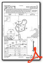
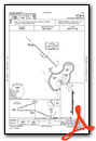
VFR Chart of KMJD
Sectional Charts at SkyVector.com
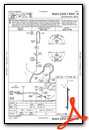
IFR Chart of KMJD
Enroute Charts at SkyVector.com
Location Information for KMJD
Coordinates: N30°29.25' / W89°39.07'Located 02 miles SE of Picayune, Mississippi on 231 acres of land. View all Airports in Mississippi.
Surveyed Elevation is 55 feet MSL.
Operations Data
|
|
Airport Communications
| AWOS-3PT: | 119.075 Tel. 601-798-4136 |
|---|---|
| GULFPORT APPROACH: | 124.6 354.1 |
| GULFPORT DEPARTURE: | 124.6 354.1 |
| UNICOM: | 122.800 |
| CTAF: | 122.800 |
| AWOS-3PT at HSA (12.1 SE): | 118.375 228-466-9320 |
| ASOS at ASD (12.4 SW): | 132.475 985-643-7263 |
| AWOS-3PT at BXA (21.9 NW): | 118.025 985-732-6224 |
- APCH/DEP SVC PRVDD BY HOUSTON ARTCC (ZHU) ON FREQS 127.65/285.475 (MOBILE RCAG) WHEN GULFPORT APCH CTL (GPT) CLSD.
Nearby Navigation Aids
|
| ||||||||||||||||||||||||||||||||||||||||||||||||||||||||||||


Runway 18/36
| Dimensions: | 5000 x 75 feet / 1524 x 23 meters | |
|---|---|---|
| Surface: | Asphalt in Good Condition | |
| Weight Limits: | S-30 | |
| Edge Lighting: | Medium Intensity | |
| Runway 18 | Runway 36 | |
| Coordinates: | N30°29.66' / W89°39.07' | N30°28.84' / W89°39.07' |
| Elevation: | 55.1 | 48.9 |
| Runway Heading: | 180° True | 0 |
| Markings: | Non-Precision Instrument in fair condition. | Non-Precision Instrument in fair condition. |
| Glide Slope Indicator | P2L (3.00° Glide Path Angle) | P2L (3.00° Glide Path Angle) |
| Obstacles: | 56 ft Trees 1715 ft from runway | 29 ft Tree 1200 ft from runway, 300 ft left of center |
Services Available
| Fuel: | 100LL (blue), Jet-A |
|---|---|
| Transient Storage: | Hangars,Tiedowns PILOTS MUST PRVD THEIR OWN TIEDOWN ROPES. |
| Airframe Repair: | MAJOR |
| Engine Repair: | MAJOR |
| Bottled Oxygen: | NOT AVAILABLE |
| Bulk Oxygen: | NOT AVAILABLE |
| Other Services: | PILOT INSTRUCTION |
Ownership Information
| Ownership: | Publicly owned | |
|---|---|---|
| Owner: | CITY OF PICAYUNE | |
| 203 GOODYEAR BLVD | ||
| PICAYUNE, MS 39466 | ||
| 601-798-9770 | ||
| Manager: | WAYNE WILSON | |
| 148 RUNWAY RD | ||
| PICAYUNE, MS 39466 | ||
| 601-590-0260 | ARPT HAS 24 HR LGTD & SCTY CAMERAS AT FUEL-FARM & TRML BLDG. 24 HR ACES FOR PILOTS & PAX AT TRML BLDG. ALTN FONE 601-749-7017. | |
Other Remarks
- THIS AIRPORT HAS BEEN SURVEYED BY THE NATIONAL GEODETIC SURVEY.
- BIRDS & GEESE INVOF ARPT.
- CK NOTAMS FOR OCNL RSTRD ASP USE BY STENNIS SPACE CNTR.
- FOR CD CTC GULFPORT APCH AT 228-265-6151, WHEN APCH CLSD CTC HOUSTON ARTCC AT 281-230-5622.
- COURTESY VEHICLE AVBL.
- (CONTACT TITLE) JIM LUKE, CITY MAYOR.
- 0LL FUEL AVBL 24 HRS WITH CREDIT CARD.
- CCTV AT TERMINAL AND FUEL PUMPS.
- ACTVT PAPI RWY 18 & 36; MIRL RWY 18/36 - CTAF.
Weather Minimums


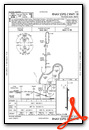
Instrument Approach Procedure (IAP) Charts
Nearby Airports with Instrument Procedures
| ID | Name | Heading / Distance | ||
|---|---|---|---|---|
 |
KASD | Slidell Airport | 226° | 12.2 |
|
KHSA | Stennis International Airport | 125° | 12.5 |
|
M13 | Poplarville/Pearl River County Airport | 022° | 19.4 |
|
KBXA | George R Carr Memorial Air Field Airport | 330° | 22.4 |
|
KGPT | Gulfport-Biloxi International Airport | 098° | 30.5 |
|
M24 | Dean Griffin Memorial Airport | 049° | 33.1 |
|
KNEW | Lakefront Airport | 216° | 33.1 |
|
KBIX | Keesler AFB Airport | 096° | 38.0 |
|
KHDC | Hammond Northshore Regional Airport | 273° | 39.8 |
|
KMSY | Louis Armstrong New Orleans International Airport | 227° | 43.3 |
|
KNBG | New Orleans NAS Jrb (Alvin Callender Field) Airport | 206° | 44.1 |
|
0R0 | Columbia/Marion County Airport | 350° | 49.2 |
Airport Images
Do you have a recent image of this airport? Upload it here!


