Login
Register


N98
Boyne City Municipal Airport
Official FAA Data Effective 2025-11-27 0901Z
Chart Supplement

VFR Chart of N98
Sectional Charts at SkyVector.com
IFR Chart of N98
Enroute Charts at SkyVector.com
Location Information for N98
Coordinates: N45°12.53' / W84°59.39'Located 01 miles E of Boyne City, Michigan on 45 acres of land. View all Airports in Michigan.
Surveyed Elevation is 659 feet MSL.
Operations Data
|
|
Airport Communications
| UNICOM: | 122.800 |
|---|---|
| CTAF: | 122.800 |
| AWOS-3PT at BFA (3.8 SE): | 118.675 231-330-8677 |
| AWOS-3P at CVX (13.1 NW): | 120.0 231-237-9703 |
| AWOS-3P at MGN (13.3 N): | 119.925 231-347-5231 |
- APCH/DEP SVC PRVDD BY MINNEAPOLIS ARTCC (ZMP) ON FREQ 134.6/354.05 (PELLSTON RCAG).
Nearby Navigation Aids
|
| ||||||||||||||||||||||||||||||||||||||||||||||||||||||||||||


Runway 09/27
| Dimensions: | 4001 x 75 feet / 1220 x 23 meters | |
|---|---|---|
| Surface: | Asphalt in Good Condition | |
| Edge Lighting: | Medium Intensity | |
| Runway 09 | Runway 27 | |
| Coordinates: | N45°12.54' / W84°59.86' | N45°12.51' / W84°58.93' |
| Elevation: | 653.0 | 656.0 |
| Traffic Pattern: | Left | Left |
| Runway Heading: | 93° True | 273° True |
| Displaced Threshold: | 599 Feet | |
| Markings: | Non-Precision Instrument in good condition. | Non-Precision Instrument in good condition. |
| Glide Slope Indicator | P2L (4.00° Glide Path Angle) | |
| REIL: | Yes | |
| Obstacles: | 19 ft Road 201 ft from runway 66 FT TREES, 624 FT DIST FM DTHR, 125-186 FT L, APCH RATIO 9:1 TO DTHR. +6 FT FENCE, 175 FT DIST; 19 FT ROAD, 197 FT DIST. |
17 ft Road 200 ft from runway, 146 ft left of center CTLG OBSTN EXCEEDS A 45 DEG SLP. 5 FT TREE, 190 FT DIST, 115 & 125 FT R. |
Services Available
| Fuel: | 100LL (blue) |
|---|---|
| Transient Storage: | Tiedowns ROPES NOT PRVDD. |
| Airframe Repair: | NOT AVAILABLE |
| Engine Repair: | NOT AVAILABLE |
| Bottled Oxygen: | NONE |
| Bulk Oxygen: | NONE |
| Other Services: | PILOT INSTRUCTION |
Ownership Information
| Ownership: | Publicly owned | |
|---|---|---|
| Owner: | CITY OF BOYNE CITY | |
| 319 N LAKE ST | ||
| BOYNE CITY, MI 49712-2111 | ||
| 231-582-6597 | ||
| Manager: | MICHAEL CAIN | |
| 319 N LAKE ST | ||
| BOYNE CITY, MI 49712-2111 | ||
| 231-675-0636 | ||
Other Remarks
- RWY 27 +250 FT HILL, 2 NM EAST, 16:1; +20 FT TREES, 480 FT DIST, 145 FT R, 14:1.
- OVNGT PRKG FEE.
- DEER & BIRDS ON & INVOF ARPT.
- ADMIN BLDG ACES: PRESS 5, THEN 3 & 2 SIMUL, THEN 1.
- FOR CD CTC MINNEAPOLIS ARTCC AT 651-463-5588.
- FIRING RANGE NE OF FLD OPRS AT UNSKED TIMES, FOR ADZY CTC BOYNE CITY POLICE DEPT AT 231-582-6611.
- 0LL SELF SVC.
- ACTVT REIL RWY 27; PAPI RWY 09; MIRL RWY 09/27 - 122.9.
Weather Minimums

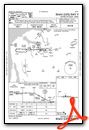
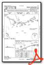
Instrument Approach Procedure (IAP) Charts
Nearby Airports with Instrument Procedures
| ID | Name | Heading / Distance | ||
|---|---|---|---|---|
 |
KBFA | Boyne Mountain Airport | 132° | 3.8 |
|
KCVX | Charlevoix Municipal Airport | 295° | 13.4 |
|
KMGN | Harbor Springs Airport | 013° | 13.4 |
|
KACB | Antrim County Airport | 213° | 15.9 |
|
KGLR | Gaylord Regional Airport | 133° | 16.9 |
|
KPLN | Pellston Regional/Emmet County Airport | 020° | 23.2 |
|
KSLH | Cheboygan County Airport | 036° | 33.3 |
|
KGOV | Grayling AAF Airport | 160° | 33.6 |
|
KTVC | Cherry Capital Airport | 222° | 37.7 |
|
KSJX | Beaver Island Airport | 320° | 37.9 |
|
6Y1 | Bois Blanc Island Airport | 031° | 39.2 |
|
KMCD | Mackinac Island Airport | 020° | 42.1 |
Airport Images
Do you have a recent image of this airport? Upload it here!


