Login
Register


SJX
Beaver Island Airport
Official FAA Data Effective 2026-02-19 0901Z
Chart Supplement

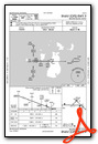
VFR Chart of KSJX
Sectional Charts at SkyVector.com
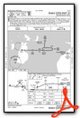
IFR Chart of KSJX
Enroute Charts at SkyVector.com
Location Information for KSJX
Coordinates: N45°41.53' / W85°34.00'Located 04 miles SW of Beaver Island, Michigan on 130 acres of land. View all Airports in Michigan.
Surveyed Elevation is 669 feet MSL.
Operations Data
|
|
Airport Communications
| AWOS-3: | 118.075 Tel. 231-448-3081 |
|---|---|
| UNICOM: | 122.800 |
| CTAF: | 122.800 |
| AWOS-3P at CVX (26.5 SE): | 120.0 231-237-9703 |
| AWOS-3P at ISQ (30.4 NW): | 118.775 906-341-8585 |
| AWOS-3P at MGN (31.8 SE): | 119.925 231-347-5231 |
- APCH/DEP SVC PRVDD BY MINNEAPOLIS ARTCC ON FREQS 134.6/354.05 (PELLSTON RCAG).
Nearby Navigation Aids
|
| ||||||||||||||||||||||||||||||||||||||||||||||||||||||||||||


Runway 09/27
| Dimensions: | 4299 x 75 feet / 1310 x 23 meters | |
|---|---|---|
| Surface: | Asphalt in Good Condition | |
| Edge Lighting: | Medium Intensity | |
| Runway 09 | Runway 27 | |
| Coordinates: | N45°41.49' / W85°34.66' | N45°41.48' / W85°33.65' |
| Elevation: | 669.7 | 667.3 |
| Traffic Pattern: | Left | Left |
| Runway Heading: | 91° True | 271° True |
| Markings: | Non-Precision Instrument in fair condition. | Non-Precision Instrument in fair condition. |
| Glide Slope Indicator | P4L (3.00° Glide Path Angle) | P4L (4.00° Glide Path Angle) |
| REIL: | Yes | Yes |
| Obstacles: | 67 ft Tree 1010 ft from runway, 330 ft right of center | |
Runway 14/32
CLSD NOV-APR & WHEN SNOW COVD. | ||
| Dimensions: | 3278 x 120 feet / 999 x 37 meters | |
|---|---|---|
| Surface: | Turf in Good Condition | |
| Runway 14 | Runway 32 | |
| Coordinates: | N45°41.72' / W85°34.07' | N45°41.35' / W85°33.51' |
| Elevation: | 666.3 | 668.0 |
| Traffic Pattern: | Left | |
| Runway Heading: | 133° True | 313° True |
| Displaced Threshold: | 522 Feet | 571 Feet |
| Obstacles: | 70 ft Trees 0 ft from runway, 125 ft left of center APCH RATIO 6:1 TO DTHR. |
15 ft Road 75 ft from runway, 133 ft right of center APCH RATIO 13:1 TO DTHR. |
Runway 05/23
CLSD NOV-APR & WHEN SNOW COVD. | ||
| Dimensions: | 2054 x 120 feet / 626 x 37 meters | |
|---|---|---|
| Surface: | Turf in Good Condition | |
| Runway 05 | Runway 23 | |
| Coordinates: | N45°41.51' / W85°34.16' | N45°41.75' / W85°33.82' |
| Elevation: | 665.5 | 664.9 |
| Traffic Pattern: | Left | Left |
| Runway Heading: | 45° True | 225° True |
| Displaced Threshold: | 763 Feet | |
| Obstacles: | 82 ft Trees 1238 ft from runway | 49 ft Trees 230 ft from runway, 130 ft left of center APCH RATIO 17:1 TO DTHR. |
Services Available
| Fuel: | 100LL (blue) |
|---|---|
| Transient Storage: | Tiedowns |
| Airframe Repair: | NONE |
| Engine Repair: | NONE |
| Bottled Oxygen: | NONE |
| Bulk Oxygen: | NONE |
| Other Services: | CHARTER SERVICE |
Ownership Information
| Ownership: | Publicly owned | |
|---|---|---|
| Owner: | ST JAMES & PEAINE TOWNSHIPS | |
| BEAVER ISLAND AIRPORT | ||
| BEAVER ISLAND, MI 49782 | ||
| 231-448-2750 | ||
| Manager: | RACHEL TEAGUE | |
| PO BOX 134 | ||
| BEAVER ISLAND, MI 49782-0134 | ||
| 231-237-9482 | CELL 231-675-5391. | |
Other Remarks
- DEER & BIRDS ON & INVOF ARPT.
- FOR CD CTC MINNEAPOLIS ARTCC AT 651-463-5588.
- 3 FT YELLOW CONES.
- 3 FT YELLOW CONES; DTHR MKD WITH 3 CONES EACH SIDE.
- 3 FT YELLOW CONES; DTHR MKD WITH 3 CONES EACH SIDE.
- 3 FT YELLOW CONES; DTHR MKD WITH 3 CONES EACH SIDE.
- ACTVT REIL RWY 09 & 27; PAPI RWY 09 & 27; MIRL RWY 09/27 - CTAF.
Weather Minimums


Instrument Approach Procedure (IAP) Charts
Nearby Airports with Instrument Procedures
| ID | Name | Heading / Distance | ||
|---|---|---|---|---|
 |
KCVX | Charlevoix Municipal Airport | 152° | 26.3 |
|
KISQ | Schoolcraft County Airport | 303° | 30.5 |
|
KMGN | Harbor Springs Airport | 119° | 31.9 |
|
KPLN | Pellston Regional/Emmet County Airport | 102° | 33.2 |
|
83D | Mackinac County Airport | 070° | 36.8 |
|
KERY | Luce County Airport | 006° | 37.4 |
|
N98 | Boyne City Municipal Airport | 139° | 37.9 |
|
KMCD | Mackinac Island Airport | 074° | 40.4 |
|
KBFA | Boyne Mountain Airport | 139° | 41.7 |
|
KSLH | Cheboygan County Airport | 092° | 44.1 |
|
6Y1 | Bois Blanc Island Airport | 083° | 44.9 |
|
KACB | Antrim County Airport | 159° | 45.0 |
Airport Images
Do you have a recent image of this airport? Upload it here!


