Login
Register


O69
Petaluma Municipal Airport
Official FAA Data Effective 2026-01-22 0901Z
Chart Supplement

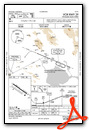
VFR Chart of O69
Sectional Charts at SkyVector.com
IFR Chart of O69
Enroute Charts at SkyVector.com
Location Information for O69
Coordinates: N38°15.47' / W122°36.32'Located 01 miles NE of Petaluma, California on 220 acres of land. View all Airports in California.
Surveyed Elevation is 90 feet MSL.
Operations Data
|
|
Airport Communications
| AWOS-3P: | 132.325 Tel. 707-773-1529 |
|---|---|
| CTAF: | 122.700 |
| UNICOM: | 122.700 |
| AWOS-3P at DVO (7.4 S): | 120.675 415-897-2236 |
| ATIS at APC (15.5 E): | 124.05 |
| ASOS at APC (15.6 E): | 707-252-7916 |
- APCH/DEP CTL SVC PRVDD BY OAKLAND ARTCC (ZOA) ON FREQ 127.8/353.5 (MOUNT TAMALPAIS RCAG).
Nearby Navigation Aids
|
| ||||||||||||||||||||||||||||||||||||


Runway 11/29
| Dimensions: | 3600 x 75 feet / 1097 x 23 meters | |
|---|---|---|
| Surface: | Asphalt in Excellent Condition | |
| Weight Limits: | S-12 | |
| Edge Lighting: | Medium Intensity | |
| Runway 11 | Runway 29 | |
| Coordinates: | N38°15.64' / W122°36.63' | N38°15.30' / W122°36.01' |
| Elevation: | 90.2 | 77.5 |
| Traffic Pattern: | Left | Right |
| Runway Heading: | 125° True | 305° True |
| Markings: | Non-Precision Instrument in good condition. | Non-Precision Instrument in good condition. |
| Glide Slope Indicator | P4L (3.00° Glide Path Angle) | |
| REIL: | Yes | |
| Obstacles: | 65 ft Trees 2500 ft from runway, 150 ft left of center | |
Services Available
| Fuel: | 100LL (blue), Jet-A |
|---|---|
| Transient Storage: | Tiedowns |
| Airframe Repair: | MAJOR |
| Engine Repair: | MAJOR |
| Bottled Oxygen: | HIGH/LOW |
| Bulk Oxygen: | LOW |
| Other Services: | PILOT INSTRUCTION,AIRCRAFT RENTAL,AIRCRAFT SALES |
Ownership Information
| Ownership: | Publicly owned | |
|---|---|---|
| Owner: | CITY OF PETALUMA | |
| PO BOX 61 | ||
| PETALUMA, CA 94952 | ||
| 707-778-4345 | ||
| Manager: | DANIEL COHEN | |
| 601 SKY RANCH DRIVE | ||
| PETALUMA, CA 94954 | ||
| 707-778-4404 | ||
Other Remarks
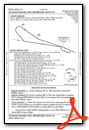
- NOISE ABATEMENT PROCEDURE 800 FT MSL BEFORE CROSSWIND TURN; STRAIGHT OUT CLIMB TO 1500 FT MSL FOR DEPS; DOWNWIND STAY OUTSIDE ADOBE RD; AVOID OVERFLIGHTS OF THE OLD ODOBE HISTORIC PARK.
- FOR CD CTC OAKLAND ARTCC AT 510-745-3380.
- CALM WIND RWY 29.
- ACTVT REIL RWY 29; PAPI RWY 29; MIRL RWY 11/29 - CTAF.
Weather Minimums


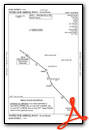
Standard Terminal Arrival (STAR) Charts
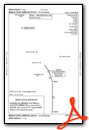
Instrument Approach Procedure (IAP) Charts

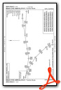
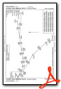
Departure Procedure Obstacles (DPO) Charts
Nearby Airports with Instrument Procedures
| ID | Name | Heading / Distance | ||
|---|---|---|---|---|
 |
KDVO | Gnoss Field Airport | 161° | 7.2 |
|
CA35 | San Rafael Airport | 164° | 15.0 |
|
KAPC | Napa County Airport | 099° | 15.6 |
|
KSTS | Charles M Schulz/Sonoma County Airport | 327° | 18.0 |
|
KHES | Healdsburg Municipal Airport | 329° | 27.4 |
|
KCCR | Buchanan Field Airport | 121° | 30.5 |
|
KVCB | Nut Tree Airport | 076° | 31.3 |
|
KSUU | Travis AFB Airport | 089° | 32.2 |
|
O60 | Cloverdale Municipal Airport | 329° | 36.0 |
|
KOAK | Oakland San Francisco Bay Airport | 150° | 37.0 |
|
KSFO | San Francisco International Airport | 164° | 39.8 |
|
KDWA | Yolo County Airport | 061° | 40.2 |
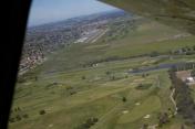
Airport Images

By: jgills240
By: bobveznat


