Login
Register


OKZ
Kaolin Field Airport
Official FAA Data Effective 2026-01-22 0901Z
Chart Supplement

VFR Chart of KOKZ
Sectional Charts at SkyVector.com
IFR Chart of KOKZ
Enroute Charts at SkyVector.com
Location Information for KOKZ
Coordinates: N32°57.98' / W82°50.25'Located 02 miles SW of Sandersville, Georgia on 105 acres of land. View all Airports in Georgia.
Surveyed Elevation is 438 feet MSL.
Operations Data
|
|
Airport Communications
| AWOS-3: | 120.575 Tel. 478-240-9432 |
|---|---|
| ATLANTA APPROACH: | 124.2 279.6 388.2 ;7000 FT & ABV |
| ATLANTA DEPARTURE: | 124.2 279.6 388.2 ;7000 FT & ABV |
| UNICOM: | 123.000 |
| CTAF: | 123.000 |
| AWOS-3PT at 2J3 (22.7 E): | 119.35 478-625-8303 |
| AWOS-3 at MLJ (23.2 NW): | 120.925 478-445-7718 |
| AWOS-3 at DBN (25.3 S): | 118.425 478-277-9051 |
- ATLANTA LARGE TRACON PROVIDES APCH/DEP SVC 0615-2300 ON FREQ 124.2; ATLANTA ARTCC PROVIDES APCH/DEP SVC 2300-0615 ON FREQS 123.95/269.3 (MACON RCAG).
Nearby Navigation Aids
|
| ||||||||||||||||||||||||||||||||||||||||||||||||||||||||||||


Runway 13/31
| Dimensions: | 5501 x 75 feet / 1677 x 23 meters | |
|---|---|---|
| Surface: | Asphalt in Good Condition | |
| Weight Limits: | S-17 | |
| Edge Lighting: | Medium Intensity | |
| Runway 13 | Runway 31 | |
| Coordinates: | N32°58.21' / W82°50.71' | N32°57.75' / W82°49.79' |
| Elevation: | 407.1 | 435.2 |
| Traffic Pattern: | Left | Left |
| Runway Heading: | 120° True | 300° True |
| Displaced Threshold: | 486 Feet | |
| Declared Distances: | TORA:5501 TODA:5501 ASDA:5501 LDA:5501 | TORA:5501 TODA:5501 ASDA:5501 LDA:5015 |
| Markings: | Non-Precision Instrument in good condition. | Non-Precision Instrument in good condition. |
| Glide Slope Indicator | P2L (3.00° Glide Path Angle) | P2L (3.60° Glide Path Angle) |
| REIL: | Yes | |
| Obstacles: | 21 ft Trees 450 ft from runway, 276 ft left of center | 60 ft Pole 1099 ft from runway, 382 ft right of center |
Services Available
| Fuel: | 100LL (blue), Jet A+ |
|---|---|
| Transient Storage: | Tiedowns |
| Airframe Repair: | MAJOR |
| Engine Repair: | MAJOR |
| Bottled Oxygen: | NONE |
| Bulk Oxygen: | NONE |
Ownership Information
| Ownership: | Publicly owned | |
|---|---|---|
| Owner: | WASHINGTON CO | AND CITY OF SANDERSVILLE |
| PO BOX 271 | ||
| SANDERSVILLE, GA 31082 | ||
| 478-552-9136 | ||
| Manager: | RAY LAWRENCE | |
| 1726 KAOLIN RD | ||
| SANDERSVILLE, GA 31082 | ||
| 478-552-9136 | ||
Other Remarks
- DEER ON & INVOF RYS & TWYS.
- FOR CD CTC ATLANTA APCH AT 678-364-6132, WHEN APCH CLSD CTC ATLANTA ARTCC AT 770-210-7692.
- REIL RWY 13; MIRL RWY 13/31 PRESET LOW INTST DUSK-2200; TO INCR INTST & ACTVT AFT 2200 - CTAF. ACTVT PAPI RWYS 13 & 31 - CTAF.
Weather Minimums

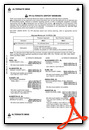
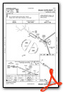
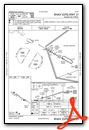
Instrument Approach Procedure (IAP) Charts
Nearby Airports with Instrument Procedures
| ID | Name | Heading / Distance | ||
|---|---|---|---|---|
 |
2J3 | Louisville Municipal Airport | 086° | 22.9 |
|
KMLJ | Baldwin County Regional Airport | 299° | 23.3 |
|
KDBN | W H 'Bud' Barron Airport | 197° | 25.2 |
|
KSBO | East Georgia Regional Airport | 132° | 31.9 |
|
KHQU | Thomson/Mcduffie County Airport | 025° | 37.4 |
|
KMAC | Macon Downtown Airport | 256° | 37.6 |
|
48A | Cochran Airport | 213° | 40.6 |
|
KCPP | Greene County Regional Airport | 338° | 40.7 |
|
KBXG | Burke County Airport | 083° | 42.3 |
|
KWRB | Robins AFB Airport | 243° | 42.9 |
|
KMCN | Middle Georgia Regional Airport | 248° | 44.2 |
|
2J5 | Millen Airport | 095° | 44.3 |
Airport Images
Do you have a recent image of this airport? Upload it here!


